world.wikisort.org - Brazil
São Francisco de Paula is a city in the Serra Gaúcha of the state of Rio Grande do Sul, Brazil. The municipality covers about 3,289.7 km2 (1,270.2 sq mi) and sits about 112 km (70 mi) from Porto Alegre. As of 2020, the city's population was estimated to be 21,801. The municipality was originally created on December 23, 1902.
São Francisco de Paula | |
|---|---|
Municipality | |
| Municipality of São Francisco de Paula | |
São Bernardo Lake in São Chico | |
 Seal | |
| Nickname: São Chico | |
 Location in Rio Grande do Sul | |
 São Francisco de Paula Location in Brazil | |
| Coordinates: 29°26′40″S 50°34′50″W | |
| Country | |
| Region | South |
| State | |
| Founded | May 21, 1878 |
| Government | |
| • Mayor | Antonio Juarez Hampel Schlichting (PTB) |
| Area | |
| • Total | 3,273.498 km2 (1,263.905 sq mi) |
| Elevation | 907 m (2,976 ft) |
| Population (2020)[1] | |
| • Total | 21,801 |
| • Density | 6.7/km2 (17/sq mi) |
| Time zone | UTC−3 (BRT) |
| HDI (2010) | 0.685 – medium[2] |
| Website | saofranciscodepaula |


The city is a tourist destination and is a link along two official scenic tourist routes: the Região das Hortênsias and the Rota Romântica.
The municipality contains the São Francisco de Paula National Forest, a 1,616 hectares (3,990 acres) sustainable use conservation area created in 1968.[3] It also contains part of the 6,655 hectares (16,440 acres) Tainhas State Park, created in 1975.[4]
Climate
São Francisco de Paula features an Oceanic climate (type Cfb), with humid, cool-to-warm summers and humid, cold winters. Snowfalls may occur during winter between July and August. It is the wettest place in Rio Grande do Sul State with more than 2,100 millimetres (83 in) of rain precipitation per year.
| Month | Jan | Feb | Mar | Apr | May | Jun | Jul | Aug | Sep | Oct | Nov | Dec | Year |
|---|---|---|---|---|---|---|---|---|---|---|---|---|---|
| Average high °C (°F) | 24.9 (76.8) |
24.2 (75.6) |
23.0 (73.4) |
19.9 (67.8) |
17.6 (63.7) |
16.3 (61.3) |
16.3 (61.3) |
17.3 (63.1) |
18.1 (64.6) |
20.0 (68.0) |
22.0 (71.6) |
23.3 (73.9) |
20.2 (68.4) |
| Daily mean °C (°F) | 19.8 (67.6) |
19.4 (66.9) |
18.2 (64.8) |
15.2 (59.4) |
12.9 (55.2) |
11.7 (53.1) |
11.3 (52.3) |
12.3 (54.1) |
13.4 (56.1) |
15.0 (59.0) |
16.8 (62.2) |
18.0 (64.4) |
15.3 (59.5) |
| Average low °C (°F) | 14.8 (58.6) |
14.7 (58.5) |
13.5 (56.3) |
10.5 (50.9) |
8.3 (46.9) |
7.1 (44.8) |
6.4 (43.5) |
7.4 (45.3) |
8.7 (47.7) |
10.1 (50.2) |
11.6 (52.9) |
12.7 (54.9) |
10.5 (50.9) |
| Average precipitation mm (inches) | 187.0 (7.36) |
182.0 (7.17) |
182.0 (7.17) |
169.0 (6.65) |
165.0 (6.50) |
191.0 (7.52) |
170.0 (6.69) |
170.0 (6.69) |
201.0 (7.91) |
188.0 (7.40) |
139.0 (5.47) |
166.0 (6.54) |
2,110 (83.07) |
| Source: Climate Data.[5] | |||||||||||||
Gallery
 RS-020 Highway in São Francisco de Paula
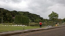 São Francisco de Paula


References
- IBGE 2020
- "Archived copy" (PDF). United Nations Development Programme (UNDP). Archived from the original (PDF) on July 8, 2014. Retrieved August 1, 2013.
{{cite web}}: CS1 maint: archived copy as title (link) - Unidade de Conservação: Floresta Nacional de São Francisco de Paula (in Portuguese), MMA: Ministério do Meio Ambiente, retrieved 2016-05-31
- "Parque Estadual de Tainhas", cambaradosul.tur.br (in Portuguese), archived from the original on 2016-02-14, retrieved 2016-12-09
- "Town Climate: São Francisco de Paula" (in Portuguese). Climate Data. Archived from the original on July 17, 2015. Retrieved October 13, 2014.
{{cite web}}: CS1 maint: bot: original URL status unknown (link)
Capital: Porto Alegre | |||||||||||||||||||||||||||||||
|  | ||||||||||||||||||||||||||||||
|
| |||||||||||||||||||||||||||||||
| |||||||||||||||||||||||||||||||
| |||||||||||||||||||||||||||||||
| |||||||||||||||||||||||||||||||
Authority control | |
|---|---|
| General | |
| National libraries | |
На других языках
[de] São Francisco de Paula (Rio Grande do Sul)
São Francisco de Paula, amtlich portugiesisch Município de São Francisco de Paula, ist eine Stadt mit 21.801 Einwohnern (Schätzung Stand: 1. Juli 2020) im Bundesstaat Rio Grande do Sul im Süden Brasiliens, die auf einem großen Gemeindegebiet von und 3317,9 km² leben. Sie liegt etwa 110 km nordöstlich von Porto Alegre.- [en] São Francisco de Paula, Rio Grande do Sul
[es] São Francisco de Paula (Río Grande del Sur)
São Francisco de Paula es un municipio brasileño del estado de Rio Grande do Sul, localizado a 105 kilómetros de la capital del estado, Porto Alegre. Fue fundado en 1902.[ru] Сан-Франсиску-ди-Паула (Риу-Гранди-ду-Сул)
Сан-Франсиску-ди-Паула (порт. São Francisco de Paula) — муниципалитет в Бразилии, входит в штат Риу-Гранди-ду-Сул. Составная часть мезорегиона Северо-восток штата Риу-Гранди-ду-Сул. Входит в экономико-статистический микрорегион Вакария. Население составляет 21 278 человек на 2007 год. Занимает площадь 3 273,498 км². Плотность населения — 6,5 чел./км².Другой контент может иметь иную лицензию. Перед использованием материалов сайта WikiSort.org внимательно изучите правила лицензирования конкретных элементов наполнения сайта.
WikiSort.org - проект по пересортировке и дополнению контента Википедии