world.wikisort.org - Brazil
Laranjeiras (English: Orange trees) is a municipality located in the Brazilian state of Sergipe. Its population was 30,080 (2020) and covers 162.27 km2 (62.65 sq mi). Laranjeiras has a population density of 180 inhabitants per square kilometer. Laranjeiras is located 19 km (12 mi) from the state capital of Sergipe, Aracaju.[2] It borders the municipalities of Riachuelo, Areia Branca, Nossa Senhora do Socorro, São Cristóvão, Maruim, and Santo Amaro das Brotas, all within the state of Sergipe. The municipality contains part of the Serra de Itabaiana National Park.[3]
Laranjeiras
Município de Laranjeiras | |
|---|---|
Municipality | |
 Historic street along Universidade Federal de Sergipe, Laranjeiras Campus | |
 Flag  Seal | |
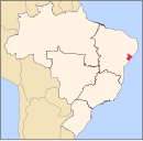
 Location of Laranjeiras in Sergipe | |
 Laranjeiras Location of Laranjeiras in Brazil | |
| Coordinates: 10°48′21″S 37°10′12″W | |
| Country | |
| Region | Northeast |
| State | |
| Founded | August 7, 1832 |
| Government | |
| • Mayor | Jose de Araujo Leite Neto |
| Area | |
| • Total | 162.27 km2 (62.65 sq mi) |
| Elevation | 9 m (30 ft) |
| Population (2020 [1]) | |
| • Total | 30,080 |
| • Density | 190/km2 (480/sq mi) |
| Demonym(s) | Laranjeirense |
| Time zone | UTC-3 (BRT) |
| Website | laranjeiras |
History
Cristóvão de Barros killed or expelled the indigenous population of the Laranjeiras area around 1530. The Portuguese soon settled on the Cotinguiba River and built a small port, called the Porto de Laranjeiras, after numerous orange trees near the port. The port became a center of the slave trade in Sergipe as a result of its access to the interior and the Atlantic Ocean. The region was intensively attacked by the Dutch from 1637; they only left Sergipe in 1645. Most of the structures of the settlement were destroyed during the Dutch occupation, but the port was preserved. The Jesuits arrived in 1701 and built a church and convent in 1701; they later completed a church on a high point in the town, the Church of Our Lady of the Conception of Comandaroba in 1734. The economy of Laranjeiras expanded due to the slave trade and the production of sugar cane, cattle, and coconut. Plantation owners built sobrados, or large town houses, in Laranjeiras. Laranjeiras remained a district of Nossa Senhora do Socorro until 1832; it was elevated to city status in 1835.[2]
Heritage sites
The architectural, urban and landscape set of Laranjeiras was listed by National Institute of Historic and Artistic Heritage in 1996. It consists of Portuguese colonial-era streets, churches, and residences, which in total includes approximately 500 buildings.
- Parish Church of the Sacred Heart of Jesus (Igreja Matriz do Coração de Jesus)
- Church of Our Lady of the Conception of Comandaroba (Igreja de Nossa Senhora da Conceição de Comandaroba)
- Chapel of the Jesus Maria José Sugar Plantation (Capela do Antigo Engenho Jesus, Maria e José)[4]
- House and Chapel of the Retiro Sugar Plantation (Engenho Retiro: casa e Capela de Santo Antônio)
- Terreiro Filhos de Obá
- Grotto of Pedra Furada (Gruta da Pedra Furada)
References
- IBGE 2020
- "Laranjeiras" (in Portuguese). Brasília, Brazil: Instituto Brasileiro de Geografia e Estatística. 2016. Retrieved 2016-11-21.
- Unidade de Conservação: Parque Nacional da Serra de Itabaiana (in Portuguese), MMA: Ministério do Meio Ambiente, retrieved 2016-05-03
- Moura Filha, Maria Berthilde (2013). "Laranjeiras". Lisbon, Portugal: Heritage of Portuguese Influence/Património de Influência Portuguesa. Retrieved 2020-02-19.
Capital: Aracaju | |||||||||||||||
| Agreste Sergipano |
|  | |||||||||||||
| Leste Sergipano |
| ||||||||||||||
| Sertao Sergipano |
| ||||||||||||||
This Sergipe, Brazil location article is a stub. You can help Wikipedia by expanding it. |
На других языках
[de] Laranjeiras (Sergipe)
Laranjeiras, amtlich portugiesisch Município de Laranjeiras, Aussprache .mw-parser-output .IPA a{text-decoration:none}[laɾɐ̃ˈʒejɾɐʃ], ist eine Stadt im Nordosten von Brasilien. Sie liegt im Bundesstaat Sergipe, hatte 26.902 Einwohner bei der Volkszählung 2010 und eine Fläche von rund 162 km².[2] Die Bevölkerungszahl wurde zum 1. Juli 2020 auf 30.080 Einwohner geschätzt, die Laranjeirenser (laranjeirenses) genannt werden.[2] Sie liegt etwa 19 km entfernt von Aracaju, der Hauptstadt des Bundesstaates.- [en] Laranjeiras, Sergipe
[ru] Ларанжейрас
Ларанжейрас (порт. Laranjeiras) — муниципалитет в Бразилии, входит в штат Сержипи. Составная часть мезорегиона Восток штата Сержипи. Входит в экономико-статистический микрорегион Байшу-Котингиба. Население составляет 26 972 человека на 2006 год. Занимает площадь 163,4 км². Плотность населения — 165,07 чел./км².Другой контент может иметь иную лицензию. Перед использованием материалов сайта WikiSort.org внимательно изучите правила лицензирования конкретных элементов наполнения сайта.
WikiSort.org - проект по пересортировке и дополнению контента Википедии