world.wikisort.org - Brazil
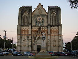
Cáceres is a municipality in the Brazilian state of Mato Grosso. It covers an area of 24,000km2 and as of 2020 had an estimated population of 94,861.
Cáceres | |
|---|---|
 | |
 | |
| Country | Brazil |
| State | Mato Grosso |
| Founded | 6 October 1778[1] |
| Population (2020 [2]) | |
| • Total | 94,861 |
| Time zone | UTC−3 (BRT) |
The town is sited on the Paraguay River, and hosts a popular fishing festival each September.[3] The municipality contains part of the Serra das Araras Ecological Station.[4] It also contains part of the Taiamã Ecological Station.[5] The municipality contains the 114,000 hectares (280,000 acres) Guirá State Park, created in 2002.[6]
Cáceres was the starting point of the Roosevelt–Rondon Scientific Expedition.[7]
Cáceres is the administrative headquarters of the Mato Grosso State University and counts with 13 graduation courses and 3 post graduation courses.[8]
References
- Ivan Sache (21 November 2010). "Cáceres, Mato Grosso (Brazil)". Flags of the World. Retrieved 8 December 2012.
- IBGE 2020
- "Thousands of piranhas infest beach, bite swimmers". Sydney Morning Herald. Fairfax Media. 17 November 2011. Retrieved 4 May 2014.
- Unidade de Conservação: Estação Ecológica da Serra das Araras (in Portuguese), MMA: Ministério do Meio Ambiente, retrieved 2016-04-19
- Unidade de Conservação: Estação Ecológica de Taiamã (in Portuguese), MMA: Ministério do Meio Ambiente, retrieved 2016-04-18
- Parque Estadual Guirá (in Portuguese), Via Rural, archived from the original on 2016-12-20, retrieved 2016-12-08
- Roosevel-Rondon Scientifi Expedition Website, retrieved 2017-03-27
- UNEMAT Website (in Portuguese), retrieved 2017-03-27
External links
 Cáceres, Mato Grosso travel guide from Wikivoyage
- Cáceres Governo Municipal (in Portuguese)
- Pantanal Escapes - Travel Guide and tourist information for Cáceres
На других языках
- [en] Cáceres, Mato Grosso
[ru] Касерис
Касерис (порт. Cáceres) — город и муниципалитет в Бразилии, входит в штат Мату-Гросу. Составная часть мезорегиона Юго-центральная часть штата Мату-Гроссу. Входит в экономико-статистический микрорегион Алту-Пантанал. Население составляет 84 175 человек на 2007 год. Занимает площадь 24 398,399 км². Плотность населения — 3.45 чел./км².Текст в блоке "Читать" взят с сайта "Википедия" и доступен по лицензии Creative Commons Attribution-ShareAlike; в отдельных случаях могут действовать дополнительные условия.
Другой контент может иметь иную лицензию. Перед использованием материалов сайта WikiSort.org внимательно изучите правила лицензирования конкретных элементов наполнения сайта.
Другой контент может иметь иную лицензию. Перед использованием материалов сайта WikiSort.org внимательно изучите правила лицензирования конкретных элементов наполнения сайта.
2019-2025
WikiSort.org - проект по пересортировке и дополнению контента Википедии
WikiSort.org - проект по пересортировке и дополнению контента Википедии


