world.wikisort.org - Bangladesh
Tetulia or Tentulia also known as "The City of Dream" or "স্বপ্নের শহর" (Bengali: তেতুলিয়া) is an upazila of Panchagarh District in the Division of Rangpur, Bangladesh.[1]
Tetulia
তেতুলিয়া | |
|---|---|
Upazila | |
 Tetulia Location in Bangladesh | |
| Coordinates: 26°29′N 88°21′E | |
| Country | |
| Division | Rangpur Division |
| District | Panchagarh District |
| Area | |
| • Total | 189.12 km2 (73.02 sq mi) |
| Population (1991) | |
| • Total | 86,760 |
| • Density | 460/km2 (1,200/sq mi) |
| Time zone | UTC+6 (BST) |
| Postal code | 5030 |
| Website | Official Map of Tetulia |
Demographics
Tetulia has a population of 124,041.[2] Males constitute 51.52% of the population, and females 48.48%. This Upazila's eighteen up population is 71,244.[3] Tetulia has an average literacy rate of 25.5% (7+ years), and the national average of 32.4% literate.[4]
Economy
The cultivation of tea, orange and pineapple is abundant in Tetulia. It is located on the Indian border with Darjeeling. A group name Kazi & Kazi has already introduced tea planting. Tea gardens have been established on plain land. Stone business is also flourishing here.

Points of interest
- Kazi & Kazi Tea Estate, Rowshanpur
- Banglabandha Land port
- Sharial Tea Garden
- Asian Highway
- Tetultola, Tetulia Chourasta
- Tetulia Gate
Administration
Tetulia Upazila is divided into seven union parishads: Banglabandha, Bhajanpur, Buraburi, Devnagar, Shalbahan, Tetulia, and Tirnaihat. The union parishads are subdivided into 36 mauzas and 246 villages.[5]
The post code of Tetulia is 5030.
Transport
Tetulia is connected by road. Nearby airport is "Saidpur Airport", which is 130 km from the town. Only Hanif Enterprise & keya Paribahan operate the bus service from Dhaka.
Gallery
 Titalia, 1891 map of Assam
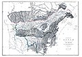
 1838 map of country between Titaleea and Darjeeling
 Titulya, on a 1776 map by James Rennell


See also
- Upazilas of Bangladesh
- Districts of Bangladesh
- Divisions of Bangladesh
References
- Shahidul Islam Shahid (2012). "Tentulia Upazila". In Sirajul Islam and Ahmed A. Jamal (ed.). Banglapedia: National Encyclopedia of Bangladesh (Second ed.). Asiatic Society of Bangladesh.
- এক নজরে তেঁতুলিয়া. tetulia.panchagarh.gov.bd (in Bengali). Retrieved 2018-12-04.
- এক নজরে তেঁতুলিয়া. tetulia.panchagarh.gov.bd. Retrieved 2018-12-04.
- "Population Census Wing, BBS". Archived from the original on 2005-03-27. Retrieved November 10, 2006.
- "District Statistics 2011: Panchagarh" (PDF). Bangladesh Bureau of Statistics. Archived from the original (PDF) on 13 November 2014. Retrieved 14 July 2014.
| Upazila/Thana: | ||
|---|---|---|
Capital: Rangpur | ||
| Dinajpur District |  | |
| Gaibandha District | ||
| Kurigram District | ||
| Lalmonirhat District | ||
| Nilphamari District | ||
| Panchagarh District | ||
| Rangpur District |
| |
| Thakurgaon District | ||
This Rangpur Division location article is a stub. You can help Wikipedia by expanding it. |
Другой контент может иметь иную лицензию. Перед использованием материалов сайта WikiSort.org внимательно изучите правила лицензирования конкретных элементов наполнения сайта.
WikiSort.org - проект по пересортировке и дополнению контента Википедии