world.wikisort.org - Bangladesh
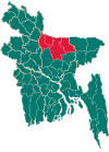
Kalmakanda (Bengali: কলমাকান্দা), originally Karamakhanda, is an upazila of Netrokona District[1] in the Division of Mymensingh, Bangladesh.
Kalmakanda
কলমাকান্দা | |
|---|---|
Upazila | |
 Kalmakanda Location in Bangladesh | |
| Coordinates: 25°5′N 90°53.5′E | |
| Country | |
| Division | Mymensingh Division |
| District | Netrokona District |
| Area | |
| • Total | 377.41 km2 (145.72 sq mi) |
| Population (2011) | |
| • Total | 217,912 |
| • Density | 580/km2 (1,500/sq mi) |
| Time zone | UTC+6 (BST) |
| Postal code | 2400 |
| Website | Official Map of Kalmakanda |
Geography
Kalmakanda is located at 25.0833°N 90.8917°E. It has 39275 households in total area 377.41 km2.
Demographics
According to 2011 Bangladesh census, Kalmakanda had a population of 217,912. Males constituted 49.61% of the population and females 50.39%. Muslims formed 85.48% of the population, Hindus 11.18%, Christians 3.17%, and others 0.18%. Kalmakanda had a literacy rate of 36.58% for the population 7 years and above.[2]
As of the 1991 Bangladesh census, Kalmakanda has a population of 209,360. Males make up 50.99% of the population, and females 49.01%. The over 18 population of Upazila numbers 103,227. Kalmakanda has an average literacy rate of 21.4% (7+ years); the national average is 32.4%.[3]
Administration
Kalmakanda Upazila is divided into eight union parishads: Barakharpan, Kaitali, Kalmakanda, Kharnai, Langura, Nazirpur, Pogla, and Rangchhati. The union parishads are subdivided into 177 mauzas and 347 villages.[4]
Notable residents
- Abdul Karim Abbasi was the Member of Parliament for constituency Netrokona-1 from 1991 to 1995 and 2001 until 2006.[5]
- Chhabi Biswas has been the Member of Parliament for constituency Netrokona-1 since 2014.[6]
- Golam Robbani was the Member of Parliament for constituency Netrokona-1 from 1988 until 1990.[7]
- Mustaque Ahmed Ruhi was the Member of Parliament for constituency Netrokona-1 from 2009 until 2014.[8]
- Jalal Uddin Talukder was the Member of Parliament for constituency Netrokona-1 from 1996 until 2001.[5]
See also
- Upazilas of Bangladesh
- Districts of Bangladesh
- Divisions of Bangladesh
References
- Syed Marufuzzaman (2012), "Kalmakanda Upazila", in Sirajul Islam and Ahmed A. Jamal (ed.), Banglapedia: National Encyclopedia of Bangladesh (Second ed.), Asiatic Society of Bangladesh
- "Bangladesh Population and Housing Census 2011: Zila Report – Netrakona" (PDF). Table P01 : Household and Population by Sex and Residence, Table P05 : Population by Religion, Age group and Residence, Table P09 : Literacy of Population 7 Years & Above by Religion, Sex and Residence. Bangladesh Bureau of Statistics (BBS), Ministry of Planning, Government of the People’s Republic of Bangladesh. Retrieved 14 December 2018.
- "Population Census Wing, BBS". Archived from the original on 2005-03-27. Retrieved November 10, 2006.
- "District Statistics 2011: Netrokona" (PDF). Bangladesh Bureau of Statistics. Archived from the original (PDF) on 13 November 2014. Retrieved 14 July 2014.
- "Parliament Election Result of 1991,1996,2001 Bangladesh Election Information and Statistics". Vote Monitor Networks. Archived from the original on 29 December 2008. Retrieved 4 February 2018.
- "Constituency 157_10th_En". Bangladesh Parliament.
- "Row Over Ticket from Netrakona-1 Constituency". The Daily Star. 21 November 2006.
- "List of 9th Parliament Members". Bangladesh Parliament.
На других языках
- [en] Kalmakanda Upazila
[ru] Калмаканда (подокруг)
Калмаканда (бенг. কলমাকান্দা, англ. Kalmakanda) — подокруг на северо-востоке Бангладеш в составе округа Нетрокона. Образован в 1941 году. Административный центр — город Калмаканда. Площадь подокруга — 377,41 км². По данным переписи 1991 года численность населения подокруга составляла 209 360 человек. Плотность населения равнялась 555 чел. на 1 км². Уровень грамотности населения составлял 21,4 %. Религиозный состав: мусульмане — 90 %, индуисты — 8,95 %, христиане — 0,8 %, прочие — 0,95 %.Другой контент может иметь иную лицензию. Перед использованием материалов сайта WikiSort.org внимательно изучите правила лицензирования конкретных элементов наполнения сайта.
WikiSort.org - проект по пересортировке и дополнению контента Википедии
