world.wikisort.org - Azerbaijan
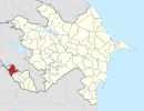
Sharur (Azerbaijani: Şərur ![]() (listen)) is a city in the Nakhchivan Autonomous Republic of Azerbaijan. It is the administrative centre of the Sharur District. The city is located 66 km northwest of Nakhchivan city, on the Sharur plain.
(listen)) is a city in the Nakhchivan Autonomous Republic of Azerbaijan. It is the administrative centre of the Sharur District. The city is located 66 km northwest of Nakhchivan city, on the Sharur plain.
Sharur
Şərur | |
|---|---|
City & Municipality | |
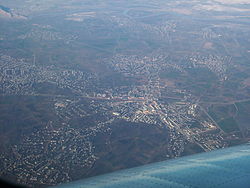
 Sharur from air | |
 Sharur | |
| Coordinates: 39°32′45″N 44°58′20″E | |
| Country | |
| Autonomous republic | Nakhchivan |
| District | Sharur |
| Population (2020)[1] | |
| • Total | 7.400 |
| Time zone | UTC+4 (AZT) |
| Area code | +994 892 |
History
In a manuscript of the 16th century Oghuz heroic epic Book of Dede Korkut stored in Dresden, the place Sheryuguz is mentioned, which, according to a Russian orientalist and historian Vasily Bartold, is a distorted form of Sharur.[2] In the Russian Empire, the town was the administrative centre of the Sharur-Daralayaz Uyezd of the Erivan Governorate and was called Bash-Norashen.[3]
In 1948, the city received the status of an urban-type settlement, and on 26 May 1964, it was renamed from Norashen to Ilyichevsk, after Vladimir Ilyich Lenin.[4][5] In 1981, Ilyichevsk received the status of a city, and in 1991 the city was renamed Sharur according to the historical name of the area.[6]
Demographics
Until 1905, Sharur, then known as Bashnorashen (Russian: Башнорашен), was composed of 100 Armenian and 25 Tatar households, a Russian primary school, telegraph-office, and a police station. The population was engaged in gardening, cultivated cotton and rice. The Armenian element of the population was eliminated during the Armenian–Tatar massacres of 1905–1907.[7] In 1897, Bashnorashen, which had the status of a selo ("rural locality"), had a population of 867 consisting of 597 Tatars and 132 Armenians.[8] In the early 20th century, the settlement had a predominantly Tatar population of 749. The same statistics indicated the existence of an 'Armenian' Bashnorashen which may have been populated by Armenians exiled from the original town, it was known as Ulya-Norashen (Улья-Норашен) and had a predominaly Armenian population of 1,458.[9]
According to official information from The State Statistics Committee of Azerbaijan, on January 1, 2020, the city had a population of about 7,400.[1]
| Ethnic group |
January 17–23, 1939.[10] | January 15–22, 1959.[11] | January 15–22, 1970.[12] | January 17–24, 1979.[13] | ||||
|---|---|---|---|---|---|---|---|---|
| Number | % | Number | % | Number | % | Number | % | |
| total | 659 | 100.00 | 1 377 | 100.00 | 2 282 | 100.00 | 3 285 | 100.00 |
| Azerbaijani | 351 | 53.26 | 1 214 | 88.16 | 2 125 | 93.12 | 3 131 | 95.31 |
| Russian and Ukrainian | 140[14] | 21.24 | 81[15] | 5.88 | 106 | 4.65 | 112 | 3.41 |
| Armenian | 129 | 19.58 | 63 | 4.58 | 29 | 1.27 | 27 | 0.82 |
| Kurd | 2 | 0.30 | ... | ... | 13 | 0.57 | 7 | 0.21 |
| Georgian | ... | ... | 1 | 0.07 | 2 | 0.09 | 1 | 0.03 |
| Tatar | ... | ... | ... | ... | 2 | 0.09 | ... | ... |
| Avar | ... | ... | ... | ... | 1 | 0.04 | ... | ... |
| German | 5 | 0.76 | ... | ... | ... | ... | ... | ... |
| Lezghin | 5 | 0.76 | ... | ... | ... | ... | ... | ... |
| Jewish | 1 | 0.15 | ... | ... | ... | ... | ... | ... |
| others | 25 | 3.79 | 18 | 1.31 | 4 | 0.18 | 7 | 0.21 |
Culture
Sharur has two parks, a stadium, a museum, a mosque, a monument-memorial to those killed in the First Nagorno-Karabakh war and a cinema.[16]
Notable natives
- Arthur Voloshin — Hero of Russia.[17]
- Adil Aliyev - is the president of Azerbaijan Kickboxing Federation and a Member of the National Assembly of Azerbaijan.
Twin Towns
 Iğdır, Turkey
References
- "Population of Azerbaijan". stat.gov.az. State Statistics Committee. Retrieved 22 February 2021.
- Bartold, Vasily (1962). Книга моего деда Коркута. Moscow: Academy of Sciences of the USSR. ISBN 978-5-02-026519-6. Retrieved 2 May 2022.
- "Баш-Норашен". Brockhaus and Efron Encyclopedic Dictionary: In 86 Volumes (82 Volumes and 4 Additional Volumes). St. Petersburg. 1890–1907.
- Поспелов, Евгений Михайлович (1998). Географические названия мира: Топонимический словарь: Свыше 5 000 единиц (in Russian). Moscow: «Русские словари». p. 160. ISBN 5-89216-029-7.
- Шарур (Ильичёвск), Great Soviet Encyclopedia
- "Шарур что такое sharur значение слова, Словарь географических названий".
- Makhmourian, Gayane. "Collection of Papers Relating to the Armenian District of Nakhijevan (1918-1920) from the U.S. Department of State and the National Archives of Armenia": 14.
{{cite journal}}: Cite journal requires|journal=(help) - "Демоскоп Weekly - Приложение. Справочник статистических показателей". www.demoscope.ru. Retrieved 2022-07-20.
- Кавказский календарь на 1910 год [Caucasian calendar for 1910] (in Russian) (65th ed.). Tiflis: Tipografiya kantselyarii Ye.I.V. na Kavkaze, kazenny dom. 1910. Archived from the original on 15 March 2022.
- Ethno-Caucasus, Этнодемография Кавказа: Население Баш-Норашенского района (по переписи 1939-го года)
- Ethno-Caucasus, Этнодемография Кавказа: Население Норашенского района (по переписи 1959-го года)
- Ethno-Caucasus, Этнодемография Кавказа: Население Ильичевского района (по переписи 1970-го года)
- Ethno-Caucasus, Этнодемография Кавказа: Население Ильичевского района (по переписи 1979-го года)
- 129 of them were Russians, and Ukrainians were 11 persons.
- All of them were ethnic Russians.
- Шопен, Иван (1852). Исторический памятник состояния Армянской области в эпоху ее присоединения к Российской империи (in Russian). Saint Petersburg. pp. 323–324. ISBN 978-5-518-09340-9. Retrieved 2 May 2022.
- Волошин Артур Владимирович (in Russian). Heroes of the country.
External links
- Sharur at GEOnet Names Server
- "Şərur rayonu - Azərbaycan". www.azerbaijans.com. Retrieved 2 May 2022.
На других языках
[de] Şərur (Stadt)
Şərur ist eine Stadt in Aserbaidschan und Hauptort des Bezirks Şərur in der Autonomen Republik Nachitschewan. Şərur hat 7.400 Einwohner (Stand: 2021). 2014 betrug die Einwohnerzahl etwa 7.100.[2]- [en] Sharur
[ru] Шарур
Шарур (азерб. Şərur) — город в Азербайджане, административный центр Шарурского района Нахичеванской Автономной Республики Азербайджана.Другой контент может иметь иную лицензию. Перед использованием материалов сайта WikiSort.org внимательно изучите правила лицензирования конкретных элементов наполнения сайта.
WikiSort.org - проект по пересортировке и дополнению контента Википедии
