world.wikisort.org - Australia
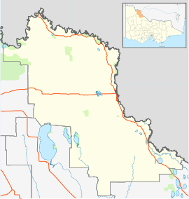
Piangil, once frequently spelled "Pyangil", is a town in the Mallee region of northern Victoria, Australia. It is approximately 382 kilometres (237 mi) north west of the state capital, Melbourne and 46 kilometres (29 mi) north west of the regional centre of Swan Hill. At the 2016 census, Piangil and the surrounding rural area had a population of 259.[1]
| Piangil Victoria | |||||||||||||||
|---|---|---|---|---|---|---|---|---|---|---|---|---|---|---|---|
 Murray St (Mallee Highway), the main street of Piangil | |||||||||||||||
 Piangil | |||||||||||||||
| Coordinates | 35°03′0″S 143°18′0″E | ||||||||||||||
| Population | 259 (2016 census)[1] | ||||||||||||||
| Postcode(s) | 3597 | ||||||||||||||
| Location |
| ||||||||||||||
| LGA(s) | Rural City of Swan Hill | ||||||||||||||
| State electorate(s) | Mildura | ||||||||||||||
| Federal division(s) | Mallee | ||||||||||||||
| |||||||||||||||
Piangil Post Office opened on 17 June 1907 and was renamed Piangil North in 1918 when Piangil was relocated adjacent to the railway station. A new Piangil Post Office opened in 1921 and is still in operation.[2]
Piangil Primary School closed in September 2015.[3]
Gallery
 General store
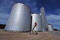 Grain storage
 Former Primary school
 Post office
 Former bowls club


References
- "2016 Census QuickStats Piangil". Australian Bureau of Statistics. Retrieved 18 August 2018.
- Phoenix Auctions History, Post Office List, retrieved 2 April 2021
- "Small school closures continue in rural Victoria". The Weekly Times. 5 November 2015. Retrieved 31 January 2019.
External links
![]() Media related to Piangil, Victoria at Wikimedia Commons
Media related to Piangil, Victoria at Wikimedia Commons
This article about a location in the Loddon Mallee (region) is a stub. You can help Wikipedia by expanding it. |
Другой контент может иметь иную лицензию. Перед использованием материалов сайта WikiSort.org внимательно изучите правила лицензирования конкретных элементов наполнения сайта.
WikiSort.org - проект по пересортировке и дополнению контента Википедии