world.wikisort.org - Australia
Kyvalley is a locality in the Goulburn Valley region of Victoria, Australia. The locality is in the Shire of Campaspe, 218 kilometres (135 mi) north of the state capital, Melbourne.
| Kyvalley Victoria | |
|---|---|
 Kyvalley Hall | |
 Kyvalley | |
| Coordinates | 36°17′2″S 145°0′21″E |
| Population | 328 (2011 census)[1] |
| Postcode(s) | 3621 |
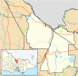
| Location |
|
| LGA(s) | Shire of Campaspe |
| State electorate(s) | Murray Plains |
| Federal division(s) | Nicholls |
At the 2011 census, Kyvalley and the surrounding area had a population of 328.[1]
References
- Australian Bureau of Statistics (31 October 2012). "Kyvalley (State Suburb)". 2011 Census QuickStats. Retrieved 4 February 2017.
External links
![]() Media related to Kyvalley at Wikimedia Commons
Media related to Kyvalley at Wikimedia Commons
Текст в блоке "Читать" взят с сайта "Википедия" и доступен по лицензии Creative Commons Attribution-ShareAlike; в отдельных случаях могут действовать дополнительные условия.
Другой контент может иметь иную лицензию. Перед использованием материалов сайта WikiSort.org внимательно изучите правила лицензирования конкретных элементов наполнения сайта.
Другой контент может иметь иную лицензию. Перед использованием материалов сайта WikiSort.org внимательно изучите правила лицензирования конкретных элементов наполнения сайта.
2019-2026
WikiSort.org - проект по пересортировке и дополнению контента Википедии
WikiSort.org - проект по пересортировке и дополнению контента Википедии