world.wikisort.org - Australia
Braefield is a locality on the Main North railway line and Kamilaroi Highway in northern New South Wales, Australia. The station opened in 1878, and no trace now remains.[2]
| Braefield New South Wales | |||||||||||||||
|---|---|---|---|---|---|---|---|---|---|---|---|---|---|---|---|
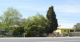
 Houses fronting the Kamilaroi Highway at Braefield | |||||||||||||||
 Braefield Location in New South Wales | |||||||||||||||
| Coordinates | 31°33′S 150°41′E | ||||||||||||||
| Population | 62 (2016 census)[1] | ||||||||||||||
| Postcode(s) | 2339 | ||||||||||||||
| Elevation | 388 m (1,273 ft) | ||||||||||||||
| Location |
| ||||||||||||||
| LGA(s) | Liverpool Plains Shire | ||||||||||||||
| Region | North West Slopes | ||||||||||||||
| County | Buckland | ||||||||||||||
| Parish | Quirindi | ||||||||||||||
| State electorate(s) | Upper Hunter | ||||||||||||||
| Federal division(s) | New England | ||||||||||||||
| |||||||||||||||
References
- Australian Bureau of Statistics (27 June 2017). "Braefield (State Suburb)". 2016 Census QuickStats. Retrieved 6 January 2018.
- Braefield station NSWrail.net, accessed 9 September 2009.
External links
![]() Media related to Braefield, New South Wales at Wikimedia Commons
Media related to Braefield, New South Wales at Wikimedia Commons
| Preceding station | Former Services | Following station | ||
|---|---|---|---|---|
| Quirindi towards Wallangarra |
Main North Line | Willow Tree towards Sydney | ||
Текст в блоке "Читать" взят с сайта "Википедия" и доступен по лицензии Creative Commons Attribution-ShareAlike; в отдельных случаях могут действовать дополнительные условия.
Другой контент может иметь иную лицензию. Перед использованием материалов сайта WikiSort.org внимательно изучите правила лицензирования конкретных элементов наполнения сайта.
Другой контент может иметь иную лицензию. Перед использованием материалов сайта WikiSort.org внимательно изучите правила лицензирования конкретных элементов наполнения сайта.
2019-2025
WikiSort.org - проект по пересортировке и дополнению контента Википедии
WikiSort.org - проект по пересортировке и дополнению контента Википедии