world.wikisort.org - Armenia
Buzhakan (Armenian: Բուժական), also Romanized as Bujhakan; formerly, Babakishi), is a village in the Kotayk Province of Armenia. It is situated along the eastern foothills of the Tsaghkunyats mountain range, upon a fertile slope. Early settlers of the village began immigrating to the area in 1829 from Bitlis, Artsap, Alashkert, Mush, Sasun, and Khoy. The community has a school, kindergarten, and a library. In a wooded area to the north of Buzhakan is the well-known 10th-14th century Teghenyats Monastery, and to the east of the village are the ruins of a 6th-7th century church.[1][2]
Buzhakan Բուժական | |
|---|---|
 Buzhakan Բուժական | |
| Coordinates: 40°27′19″N 44°31′14″E | |
| Country | Armenia |
| Marz (Province) | Kotayk |
| Founded | 1829 |
| Government | |
| • Mayor | Manvel Davtyan |
| Area | |
| • Total | 39.66 km2 (15.31 sq mi) |
| Elevation | 1,820 m (5,970 ft) |
| Population (2008) | |
| • Total | 1,822 |
| • Density | 46/km2 (120/sq mi) |
| Time zone | UTC+4 ( ) |
Gallery
 Teghenyats Monastery, 10th-14th c.

See also
References
- "Budjakan (Kotayk)". CAA: Union of Communities of Armenia. Archived from the original on May 6, 2016. Retrieved May 30, 2015.
- Kiesling, Brady; Kojian, Raffi (2005). Rediscovering Armenia: Guide (2nd ed.). Yerevan: Matit Graphic Design Studio. p. 101. ISBN 99941-0-121-8.
- Buzhakan at GEOnet Names Server
- World Gazeteer: Armenia[dead link] – World-Gazetteer.com
- Report of the results of the 2001 Armenian Census, Statistical Committee of Armenia
Capital: Hrazdan | ||
| Urban communities | 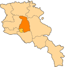 | |
| Rural communities |
| |
| Non-community settlements | ||
This article about a location in Kotayk Province, Armenia is a stub. You can help Wikipedia by expanding it. |
Текст в блоке "Читать" взят с сайта "Википедия" и доступен по лицензии Creative Commons Attribution-ShareAlike; в отдельных случаях могут действовать дополнительные условия.
Другой контент может иметь иную лицензию. Перед использованием материалов сайта WikiSort.org внимательно изучите правила лицензирования конкретных элементов наполнения сайта.
Другой контент может иметь иную лицензию. Перед использованием материалов сайта WikiSort.org внимательно изучите правила лицензирования конкретных элементов наполнения сайта.
2019-2026
WikiSort.org - проект по пересортировке и дополнению контента Википедии
WikiSort.org - проект по пересортировке и дополнению контента Википедии