world.wikisort.org - Argentina
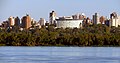
Paraná (Spanish pronunciation: [paɾaˈna]) is the capital city of the Argentine province Entre Ríos, located on the eastern shore of the Paraná River, opposite the city of Santa Fe, capital of the neighbouring Santa Fe Province. The city has a population of 247,863 (2010 census [INDEC]).
Paraná | |
|---|---|
City | |
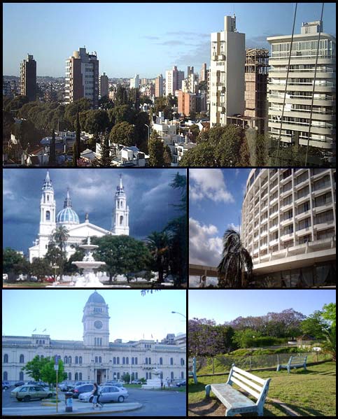 (From top to bottom; from left to right) Panoramic view of the city; Paraná Cathedral; Hotel Mayorasgo; Entre Ríos Government House and Toma Vieja. | |
 Flag  Coat of arms | |
 Paraná  Paraná  Paraná | |
| Coordinates: 31°44′S 60°32′W | |
| Country | |
| Province | |
| Department | Paraná |
| Founded | 23 October 1730 |
| Government | |
| • Mayor | Adán Bahl (Justicialist Party) |
| Area | |
| • City | 137 km2 (53 sq mi) |
| Elevation | 77 m (253 ft) |
| Population (2010 census) | |
| • Urban | 247,863 |
| Demonym | Paranaense |
| Time zone | UTC−3 (ART) |
| CPA base | E3100 |
| Dialing code | +54 343 |
| Website | Official website |
History
During the 16th century, inhabitants of the city of Santa Fe settled at the other shore of the Paraná river. The first settlers called it “Baxada del Paraná”.
Between 1854 and 1861 it was the capital city of the Argentine Confederation.
Economy
Paraná is not only the head of the provincial government, but also an important river port for the transshipment of cereals, cattle, fish, and lumber from the surrounding region. The principal industries installed are the manufacture of cement, furniture, and ceramics.
Cityscape
The centre of the city gathers colonial churches, European styles such as that of the 3 de Febrero Theatre or the Government House, the mixed styles of the city's Cathedral, and modern towers like those near the Parque Urquiza park. The city is connected to the city of Santa Fe on the other side of the Entre Ríos by the Hernandarias Subfluvial Tunnel inaugurated in 1969.

Transport
Paraná is served by General Justo José de Urquiza Airport (IATA PRA), at coordinates 31°47′07″S 60°28′09″W, 7.5 kilometres (4.7 mi) from the city, with regular flights to Buenos Aires (Aeroparque Jorge Newbery). Another option is Sauce Viejo Airport in nearby Santa Fe.
Climate
Paraná has a Pampean climate,[1] which under the Köppen climate classification, would be classified as a humid subtropical climate (Cfa).[2] The average annual temperature is 18 °C (64.4 °F).[1] Winters are characterized with mild temperatures during the day and very cold nights.[3] The average high is 18 °C (64.4 °F) while the average low is 5 °C (41.0 °F).[1] Temperatures occasionally fall below 1 °C (33.8 °F), leading to frosts.[1]
Spring and Fall are transitional seasons with warm temperatures during the day with cool temperatures during the night.[3] Normally, the last frost occurs on August 4 although frosts can occur as late as October 9.[4] The first frost occurs on June 22 though frosts as early as May has occurred.[4]
Summers are characterized by hot weather during the day with mild to warm nights.[3] The average temperature during summer is around 23 °C (73.4 °F) although heat waves can push temperatures above 37 °C (98.6 °F) while cool Pampero winds can push temperatures below 10 °C (50.0 °F).[1] Most of the precipitation occurs during the summer, receiving an average precipitation of 400 mm (16 in).[1] The city, along with the entire province is located in an area of high risk of tornadoes in the country, particularly during spring and summer.[5]
Paraná receives 1,069.1 mm (42.09 in) of precipitation per year, most of it concentrated in the summer months and there are 87 days with measurable precipitation.[6][7] The average relative humidity is 73%.[1] Wind speeds are moderate throughout the year, ranging from a low of 10.1 km/h (6.3 mph) in April to a high of 16.0 km/h (9.9 mph) in September.[3] Paraná receives an average of 2713.3 hours (or 61% of possible sunshine) of bright sunshine per year, ranging from a low of 51% in June to a high of 67% in January and February.[6] The highest temperature ever recorded was 42.8 °C (109.0 °F) on January 2, 1963, while the lowest temperature ever recorded was −7.0 °C (19.4 °F) on July 10, 1976.[8]
| Climate data for Paraná, Entre Ríos (General Justo José de Urquiza Airport) 1981–2010, extremes 1961–present | |||||||||||||
|---|---|---|---|---|---|---|---|---|---|---|---|---|---|
| Month | Jan | Feb | Mar | Apr | May | Jun | Jul | Aug | Sep | Oct | Nov | Dec | Year |
| Record high °C (°F) | 42.8 (109.0) |
39.7 (103.5) |
38.4 (101.1) |
33.5 (92.3) |
32.8 (91.0) |
30.0 (86.0) |
31.6 (88.9) |
36.0 (96.8) |
39.0 (102.2) |
38.5 (101.3) |
39.7 (103.5) |
42.0 (107.6) |
42.8 (109.0) |
| Average high °C (°F) | 31.2 (88.2) |
29.6 (85.3) |
27.9 (82.2) |
23.5 (74.3) |
20.2 (68.4) |
16.9 (62.4) |
16.6 (61.9) |
19.3 (66.7) |
21.1 (70.0) |
24.5 (76.1) |
27.2 (81.0) |
29.6 (85.3) |
24.0 (75.2) |
| Daily mean °C (°F) | 25.1 (77.2) |
23.6 (74.5) |
22.0 (71.6) |
18.0 (64.4) |
14.8 (58.6) |
12.0 (53.6) |
11.3 (52.3) |
13.2 (55.8) |
15.1 (59.2) |
18.5 (65.3) |
21.3 (70.3) |
23.6 (74.5) |
18.2 (64.8) |
| Average low °C (°F) | 19.3 (66.7) |
18.5 (65.3) |
17.1 (62.8) |
13.6 (56.5) |
10.6 (51.1) |
8.0 (46.4) |
7.1 (44.8) |
8.4 (47.1) |
9.9 (49.8) |
13.1 (55.6) |
15.6 (60.1) |
17.8 (64.0) |
13.3 (55.9) |
| Record low °C (°F) | 7.5 (45.5) |
6.9 (44.4) |
3.5 (38.3) |
0.5 (32.9) |
−2.4 (27.7) |
−6.2 (20.8) |
−7.0 (19.4) |
−5.3 (22.5) |
−3.9 (25.0) |
0.0 (32.0) |
2.3 (36.1) |
4.0 (39.2) |
−7.0 (19.4) |
| Average precipitation mm (inches) | 115.2 (4.54) |
134.8 (5.31) |
155.0 (6.10) |
132.7 (5.22) |
58.3 (2.30) |
38.2 (1.50) |
32.4 (1.28) |
32.4 (1.28) |
61.2 (2.41) |
127.6 (5.02) |
118.7 (4.67) |
141.2 (5.56) |
1,147.7 (45.19) |
| Average precipitation days (≥ 0.1 mm) | 7.6 | 8.0 | 8.0 | 8.4 | 5.4 | 4.9 | 4.3 | 4.3 | 5.6 | 9.0 | 8.2 | 9.2 | 82.9 |
| Average relative humidity (%) | 65.6 | 71.5 | 74.5 | 78.3 | 78.9 | 80.1 | 76.6 | 71.3 | 68.8 | 69.3 | 66.9 | 65.2 | 72.3 |
| Mean monthly sunshine hours | 277.3 | 236.5 | 236.8 | 194.1 | 175.7 | 144.4 | 170.8 | 199.3 | 207.2 | 234.7 | 262.7 | 244.9 | 2,620.8 |
| Percent possible sunshine | 67 | 67 | 62 | 63 | 58 | 51 | 53 | 59 | 58 | 62 | 66 | 62 | 61 |
| Source 1: Servicio Meteorológico Nacional[9][8] | |||||||||||||
| Source 2: World Meteorological Organization (sunshine hours 1981–2010),[10] NOAA (percent sun 1961–1990)[6] | |||||||||||||
| Climate data for Paraná INTA (1934–2014) | |||||||||||||
|---|---|---|---|---|---|---|---|---|---|---|---|---|---|
| Month | Jan | Feb | Mar | Apr | May | Jun | Jul | Aug | Sep | Oct | Nov | Dec | Year |
| Record high °C (°F) | 42.0 (107.6) |
40.8 (105.4) |
39.5 (103.1) |
35.2 (95.4) |
35.8 (96.4) |
29.9 (85.8) |
31.4 (88.5) |
36.4 (97.5) |
40.0 (104.0) |
39.2 (102.6) |
41.5 (106.7) |
41.5 (106.7) |
42.0 (107.6) |
| Average high °C (°F) | 30.9 (87.6) |
29.6 (85.3) |
27.3 (81.1) |
23.4 (74.1) |
20.4 (68.7) |
17.1 (62.8) |
16.9 (62.4) |
18.9 (66.0) |
21.0 (69.8) |
23.9 (75.0) |
27.0 (80.6) |
29.5 (85.1) |
23.8 (74.8) |
| Daily mean °C (°F) | 24.9 (76.8) |
23.8 (74.8) |
21.8 (71.2) |
18.2 (64.8) |
15.4 (59.7) |
12.5 (54.5) |
12.0 (53.6) |
13.4 (56.1) |
15.3 (59.5) |
18.2 (64.8) |
20.9 (69.6) |
23.5 (74.3) |
18.3 (64.9) |
| Average low °C (°F) | 18.8 (65.8) |
18.1 (64.6) |
16.5 (61.7) |
12.8 (55.0) |
10.6 (51.1) |
8.0 (46.4) |
7.0 (44.6) |
7.9 (46.2) |
9.6 (49.3) |
12.5 (54.5) |
14.9 (58.8) |
17.4 (63.3) |
12.8 (55.0) |
| Record low °C (°F) | 5.6 (42.1) |
5.0 (41.0) |
4.0 (39.2) |
1.1 (34.0) |
−1.6 (29.1) |
−3.4 (25.9) |
−5.5 (22.1) |
−3.0 (26.6) |
−1.9 (28.6) |
2.2 (36.0) |
3.6 (38.5) |
6.5 (43.7) |
−5.5 (22.1) |
| Average precipitation mm (inches) | 116 (4.6) |
110 (4.3) |
156 (6.1) |
105 (4.1) |
52 (2.0) |
39 (1.5) |
29 (1.1) |
32 (1.3) |
54 (2.1) |
106 (4.2) |
111 (4.4) |
117 (4.6) |
1,027 (40.4) |
| Average relative humidity (%) | 67 | 71 | 73 | 75 | 77 | 78 | 75 | 71 | 68 | 69 | 67 | 65 | 71 |
| Mean monthly sunshine hours | 285.2 | 237.3 | 238.7 | 198.0 | 179.8 | 147.0 | 173.6 | 195.3 | 210.0 | 235.6 | 261.0 | 279.0 | 2,640.5 |
| Mean daily sunshine hours | 9.2 | 8.4 | 7.7 | 6.5 | 5.8 | 4.9 | 5.6 | 6.3 | 7.0 | 7.6 | 8.7 | 9.0 | 7.2 |
| Source: Instituto Nacional de Tecnología Agropecuaria[11] | |||||||||||||
Sports
The city is home to the basketball team Atlético Echagüe. As of 2017, it competes in the Liga Nacional de Básquet, Argentina's top professional basketball division. It plays its home games at the Estadio Luis Butta. The main football teams are: Club Atlético Patronato and Club Atlético Paraná.
Gallery
 Paraná, Argentina
 Paraná City, Argentina
 Paraná, Argentina
 Paraná, Argentina
 Paraná, Argentina
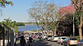 Paraná, Argentina
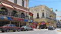 Paraná, Argentina
 Paraná, Argentina
 Paraná, Argentina
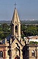 Paraná, Argentina
 Paraná, Argentina
 Paraná Cathedral, Argentina
 Paraná, Argentina
 Paraná, Argentina
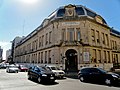 Paraná, Argentina
 Paraná, Argentina
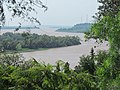 Paraná, Argentina


Sister cities
 Salto, Uruguay
 Santa Cruz de la Sierra, Bolivia[12]
 Muscatine, United States
 Quebec City, Canada
 Leonforte, Italy
Notable residents
- Salvador Maciá (1855-1929), Governor of Entre Ríos Province
- Martin Castrogiovanni (born 1981), Italy international rugby player born in the city
References
- "Características de la ciudad" (in Spanish). Gobierno Municipal de la Ciudad de Paraná. Retrieved October 9, 2015.
- Peel, M. C. and Finlayson, B. L. and McMahon, T. A. (2007). "Updated world map of the Köppen–Geiger climate classification" (PDF). Hydrol. Earth Syst. Sci. 11 (5): 1633–1644. Bibcode:2007HESS...11.1633P. doi:10.5194/hess-11-1633-2007. ISSN 1027-5606.
{{cite journal}}: CS1 maint: multiple names: authors list (link) - "Datos Estadísticos (Período 1981-1990)" (in Spanish). Servicio Meteorológico Nacional. Retrieved October 9, 2015.
- "Parana, Entre Rios". Estadísticas meteorológicas decadiales (in Spanish). Oficina de Riesgo Agropecuario. Retrieved October 9, 2015.
- "Provincia de Entre Ríos - Clima Y Meteorologia: Datos Meteorologicos Y Pluviometicos" (in Spanish). Secretaria de Mineria de la Nacion (Argentina). Archived from the original on March 9, 2009. Retrieved October 9, 2015.
- "Parana Aero Climate Normals 1961–1990". National Oceanic and Atmospheric Administration. Retrieved 30 March 2015.
- "Valores Medios de Temperatura y Precipitación-Entre Rios: Parana" (in Spanish). Servicio Meteorológico Nacional. Retrieved March 30, 2015.
- "Clima en la Argentina: Guia Climática por Paraná Aero". Caracterización: Estadísticas de largo plazo (in Spanish). Servicio Meteorológico Nacional. Archived from the original on 4 September 2017. Retrieved 5 October 2017.
- "Estadísticas Climatológicas Normales - período 1981-2010" (in Spanish). Servicio Meteorológico Nacional. Retrieved January 21, 2018.
- "World Meteorological Organization Climate Normals for 1981–2010". World Meteorological Organization. Archived from the original on 16 July 2021. Retrieved 5 October 2021.
- "Valores Promedios de la Serie Histórica - EEA Paraná" (PDF) (in Spanish). Instituto Nacional de Tecnología Agropecuaria. Retrieved December 5, 2015.
- "Asuntos Federales y Electorales". www.cancilleria.gov.ar. Archived from the original on 27 May 2012. Retrieved 11 January 2022.
External links
- Official website (in Spanish)
- Municipal information: Municipal Affairs Federal Institute (IFAM), Municipal Affairs Secretariat, Ministry of Interior, Argentina. (in Spanish)
- Universidad Nacional de Entre Ríos (in Spanish)
Provincial capitals of Argentina | ||
|---|---|---|
| ||
Authority control | |
|---|---|
| General | |
| National libraries | |
| Other |
|
На других языках
[de] Paraná (Entre Ríos)
Paraná ist die Hauptstadt der Provinz Entre Ríos im Nordosten von Argentinien. Die am östlichen Ufer des Río Paraná gegenüber Santa Fe gelegene Stadt hatte eine Einwohnerzahl von 235.967 (Stand 2001).[2] Mit Santa Fe ist sie seit 1969 über die Ruta Nacional 168 und den Túnel Hernandarias unter dem Río Paraná verbunden. Der Tunnel war die erste feste Querung des Flusses in Argentinien.- [en] Paraná, Entre Ríos
[ru] Парана (город)
Парана (исп. Paraná) — столица аргентинской провинции Энтре-Риос, расположенной на восточном берегу реки Парана, напротив города Санта-Фе, столицы соседней провинции Санта-Фе.Другой контент может иметь иную лицензию. Перед использованием материалов сайта WikiSort.org внимательно изучите правила лицензирования конкретных элементов наполнения сайта.
WikiSort.org - проект по пересортировке и дополнению контента Википедии