world.wikisort.org - Algeria
Sidi Bel Abbès (Arabic: سيدي بلعباس), also called Bel Abbès, is the capital (2005 pop. 200,000)[1] of the Sidi Bel Abbès wilaya (2005 pop. 590,000), Algeria. It is named after Sidi bel Abbass, a Muslim marabout or noble man who is buried there.[1] The city is the commercial center of an important area of vineyards, market gardens, orchards, and grain fields. It was formerly surrounded by a wall with four gates, and today is home to a university. Sidi Bel Abbès is 75 kilometers from the Mediterranean Sea.
This article needs additional citations for verification. (June 2007) |
Sidi Bel Abbès
سيدي بلعباس | |
|---|---|
City | |
 Location of Sidi Bel Abbès in the Sidi Bel Abbès Province | |
 Sidi Bel Abbès Location of Sidi Bel Abbès in Algeria  Sidi Bel Abbès Sidi Bel Abbès (Africa) | |
| Coordinates: 35°11′38″N 0°38′29″W | |
| Country | |
| Province | Sidi Bel Abbès Province |
| District | Sidi Bel Abbès District |
| APC | Miloud Magherbi (2021-2026) |
| Government | |
| • Type | Municipality |
| Area | |
| • Total | 3,533.08 sq mi (9,150.63 km2) |
| Population (2008) | |
| • Total | 212,935 |
| Time zone | UTC+1 (CET) |
| Postal code | 22000 |
| ISO 3166 code | CP |
History
The present city, on the Wadi Sig River, developed around a French camp built in 1843. In 1849 a planned agricultural town was established around the existing military post. From the 1830s until 1962 the city was closely associated with the French Foreign Legion, being the location of its basic training camp, and the headquarters of its 1st Foreign Regiment. In the late 1890s the town, described as being of Spanish appearance, had a civilian population of about 30,000.[2] The main buildings were in the French military district of the Quartier Vienot.The training centre of the modern Algerian National Gendarmerie is located in Sidi Bel Abbès.
In the 1930s much of the old city walls were demolished. Wide boulevards and squares replaced the traditional quarters, causing the town to lose much of its former character.
Geography
The city sits astride both banks of the Sig River, and lake Sidi Mohamed Benali. The lake provides a major water reserve for the area.
Climate
Sidi Bel Abbès has a hot-summer Mediterranean climate (Köppen climate classification Csa).
| Climate data for Sidi Bel Abbès | |||||||||||||
|---|---|---|---|---|---|---|---|---|---|---|---|---|---|
| Month | Jan | Feb | Mar | Apr | May | Jun | Jul | Aug | Sep | Oct | Nov | Dec | Year |
| Average high °C (°F) | 14 (57) |
15 (59) |
18 (64) |
20 (68) |
24 (75) |
29 (84) |
34 (93) |
35 (95) |
30 (86) |
24 (75) |
18 (64) |
14 (57) |
22 (71) |
| Daily mean °C (°F) | 8 (46) |
9 (48) |
11 (51) |
13 (55) |
16 (60) |
21 (69) |
25 (77) |
25 (77) |
21 (69) |
17 (62) |
12 (53) |
8 (46) |
15 (59) |
| Average low °C (°F) | 1 (33) |
2 (35) |
4 (39) |
6 (42) |
8 (46) |
12 (53) |
15 (59) |
15 (59) |
13 (55) |
9 (48) |
6 (42) |
2 (35) |
7 (44) |
| Average precipitation mm (inches) | 61 (2.4) |
48 (1.9) |
46 (1.8) |
41 (1.6) |
38 (1.5) |
10 (0.4) |
2.5 (0.1) |
5.1 (0.2) |
15 (0.6) |
38 (1.5) |
43 (1.7) |
64 (2.5) |
410 (16.1) |
| Source: Weatherbase [3] | |||||||||||||
Neighborhoods
Sidi Bel Abbès has 26 regional neighborhoods. These are: Campus, Ben Hamouda, American Village, Rocher, Sidi Djilali, Environment, Gambetta, Maconi, Soricor, La Brimer, Londeau, Sidi Yacine, Saqia Hamra, Village Perrin, Village Bira, Adda boudjelal, El Makam, El madina el Mounaouara, Bab Eddaya, Boumlik (Campo), Downtown, Grebah, Cimitiere Houria, Cite 20 Aout, Village Tierre, Village de Gaulle.
Culture
Music
Rai music is the most famous music in the city and it is known of many rai chebs Like Djilali Amarna.
Sport
Association football is the most popular sport in the city. The local football team is USM Bel Abbés, which plays in 24 Fevrier Stadium. Basketball, handball, and volleyball are also popular and are played in middle and high schools or sports complexes, such as Adda Boudjelal Sportive Complex. The city also has a rugby union club, MC Sidi Bel Abbés.
Economy
The economy centers on agriculture, particularly the production of cereals such as wheat and barley and the grape industry. A farm machine manufacturing complex is located there.[1] There is an industrial zone which plays a major role in the city's economy.
Markets
There are many markets in Sidi Bel Abbes. Souk el Felah and Souk el Lile are the main two markets for fruit and vegetables.
Transportation
Route
Sidi Bel Abbès is well connected to other Algerian cities by roads. Oran is 70 kilometers north and Tlemcen is 90 kilometers west.The West-East Route passes near the city.
Airport
The closest international airport is Oran Es Sénia,[1] but the city is served by a domestic one: Sidi Bel Abbès Airport (IATA: BFW, ICAO: DAOS)but it is not for the public use.
Tramway
The Sidi Bel Abbès tramway line was opened on July 25, 2017.[4] The light rail line is 14.7 kilometers in length, with 22 stations covering most of the main points in the city such 3 Busstations,Daira,University campus,Down Town,Public Garden.Although It doesn't serve the west of the city and the south.
Train
Sidi Bel Abbés has a railway station from which trains travel to Oran, Tlemcen, Bechar and Saïda.A rail link between Algeria and Morocco passes through the city but this link has been discontinued for political reasons..
Tourism
Landmarks
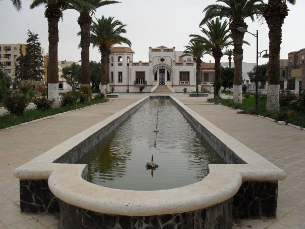
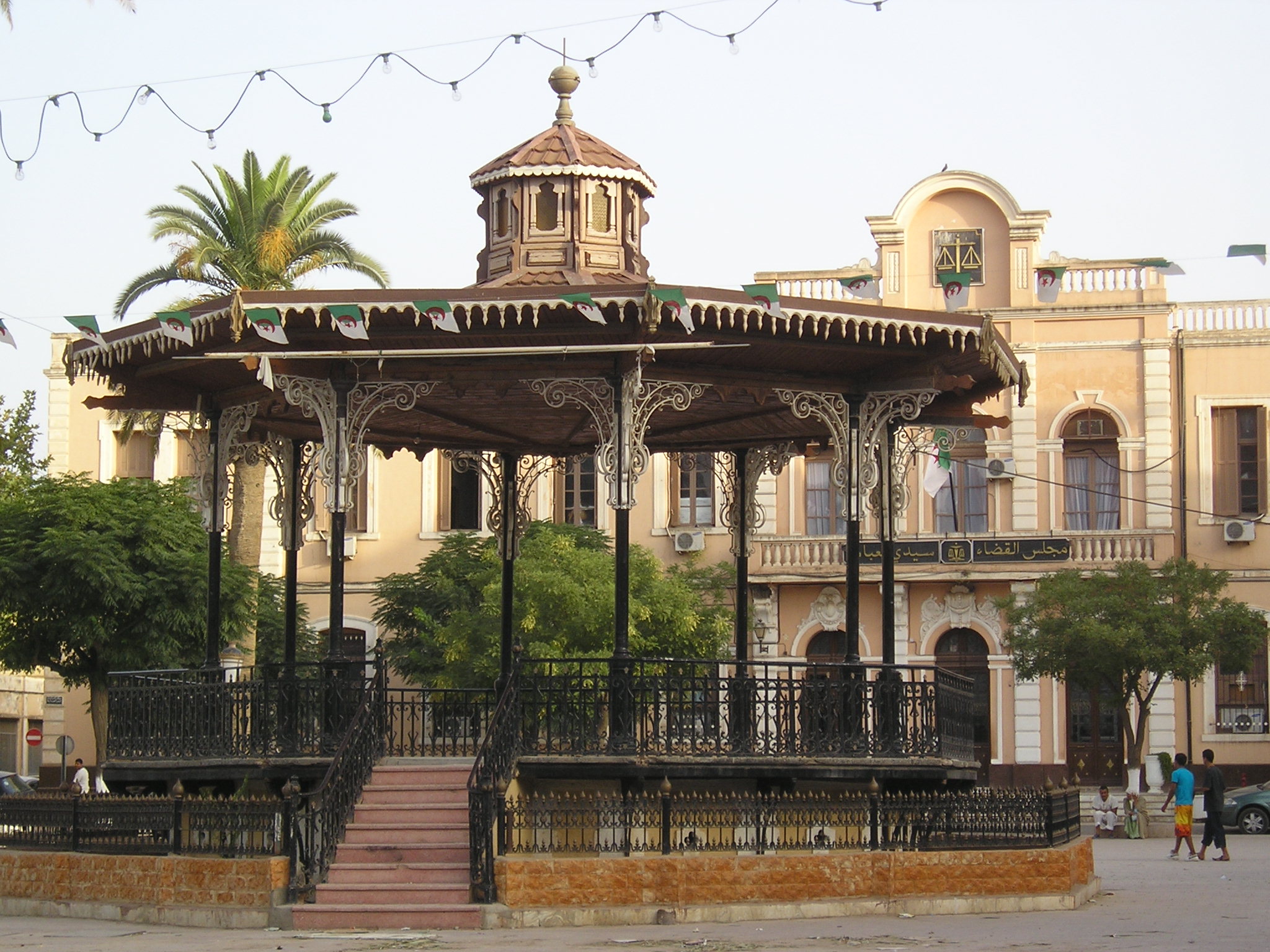
Sidi Bel Abbès has several historical landmarks. These include Place Carnot which was renamed Place 1er Novembre after independence. This is a square situated in the central city. Perrin Castle is a fortress situated between Sidi Bel Abbés and Sidi Lahcene and built in the French style of architecture, The town hall, also built in the historical French pattern was formally a cathedral. The FLN party office was in colonial times a military building.
Hotels
Sidi Bel Abbés has five hotels, including Beni tella and Eden, "Metropole I", "Metropole II", "Quods".
Notable people
- René Raphaël Viviani (November 8, 1863 – September 7, 1925), a French politician of the Third Republic, who served as Prime Minister for the first year of World War I
- Marco Torrès (January 22, 1888 - January 15, 1963), Olympic gymnast, two-time World All-Around Champion
- Gaston Maurice Julia (February 3, 1893 – March 19, 1978), mathematician famous for the Julia set in chaos theory
- Marcel Cerdan (1916–49), French boxer, known as Le Bombardier Marocain ("The Moroccan Bomber")
- Mohammed Bedjaoui (born 21 September 1929), foreign minister, former Minister of Justice (1964–70), Ambassador to France (1970–79) and Algerian permanent representative to the UN (1979–82). He was a judge on the International Court of Justice at The Hague (1982–2001).
- Jean Boyer (1948–2004), French organist
- Brigitte Giraud (born 1960), French writer
- Kad Merad (1964), actor in the 2008 French comedy film Bienvenue chez les Ch'tis
- Éric Delétang (born 1966), former French professional footballer
References
- Sidi Bel Abbes, lexicorient.com (Encyclopaedia of the Orient), internet article.
- Martin Windrow, page 138 Our Friends Beneath the Sands - The Foreign Legion in France's Colonial Conquests 1870-1935, ISBN 978-0-297-85213-1
- "Weatherbase: Historical Weather for Sidi-bel-abbes, Algeria". Weatherbase. 2011. Retrieved on November 24, 2011.
- Barrow, Keith. "Sidi Bel Abbès opens first light rail line". Retrieved 2017-07-26.
External links
- Sidi Bel Abbès on Facebook
|  | |
Capital: Sidi Bel Abbès | ||
| Districts |
|  |
| Communes |
| |
Authority control | |
|---|---|
| General | |
| National libraries | |
| Other |
|
На других языках
- [en] Sidi Bel Abbès
[ru] Сиди-Бель-Аббес
Си́ди-Бель-Аббе́с[1] (араб. سيدي بلعباس) — город на северо-западе Алжира, административный центр одноимённых вилайета и округа (фр.) (рус.. Население — 200 000 чел. (по оценке 2005 года)[2].Другой контент может иметь иную лицензию. Перед использованием материалов сайта WikiSort.org внимательно изучите правила лицензирования конкретных элементов наполнения сайта.
WikiSort.org - проект по пересортировке и дополнению контента Википедии