world.wikisort.org - Algeria
Berber languages: ⵎⵙⵉⵍⴰ Msila) is a province (wilaya) of northern Algeria. It has a population of 1 million people and an area of 18,718 km², while its capital, also called M'sila, home to M'Sila University, has a population of about 100,000.
This article needs additional citations for verification. (October 2021) |
M'Sila Province
ولاية المسيلة | |
|---|---|
Province | |
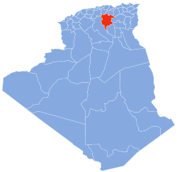 Map of Algeria highlighting M'Sila | |
| Coordinates: 35°42′N 4°33′E | |
| Country | |
| Capital | M'Sila |
| Area | |
| • Total | 18,718 km2 (7,227 sq mi) |
| Population (2008)[1] | |
| • Total | 991,846 |
| • Density | 53/km2 (140/sq mi) |
| Time zone | UTC+01 (CET) |
| Area Code | +213 (0) 35 |
| ISO 3166 code | DZ-28 |
| Districts | 15 |
| Municipalities | 47 |
Localities include Bou Saada and Maadid. Chott El Hodna, a salt lake, crosses into M'Sila. However, most of the region is semi-arid and undeveloped.
Additionally, M'Sila was the location of the first village constructed as part of a government-run program to transition nomadic Algerians to sedentary life using local materials.
The village, now complete, was dubbed Maader and consists of houses, public and trading areas, and a mosque.
History
The province was created from parts of Batna (département), Médéa (département) and Sétif (département) in 1974.
Administrative divisions
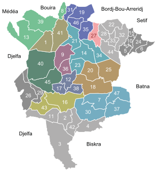
The province is divided into 15 districts (daïras), which are further divided into 47 communes or municipalities.
Districts
- Aïn El Hadjel
- Aïn El Melh
- Ben S'Rour
- Bou Saâda
- Chellal
- Djebel Messaâd
- Hammam Dhalaâ
- Khoubana
- M'sila
- Magra
- Medjedel
- Ouled Derradj
- Ouled Sidi Brahim
- Sidi Aïssa
- Sidi Ameur
Communes
- 1. Aïn El Hadjel
- 2. Aïn El Melh
- 3. Aïn Errich
- 4. Aïn Fares
- 5. Aïn Khadra
- 6. Belaïba
- 7. Ben Srour
- 8. Beni Ilmane
- 9. Benzouh
- 10. Berhoum
- 11. Bir Foda
- 12. Bou-Saâda
- 13. Bouti Sayeh
- 14. Chellal
- 15. Dehahna
- 16. Djebel Messaad
- 17. El Hamel
- 18. El Houamed
- 19. Hammam Dhalaa
- 20. Khoubana
- 21. Khatouti Sed Eldjir
- 22. Maadid
- 23. Maarif
- 24. Magra
- 25. M'cif
- 26. Medjedel
- 27. M'sila
- 28. M'Tarfa
- 29. Menaa
- 30. Mohamed Boudiaf
- 31. Ouanougha
- 32. Ouled Addi Guebala
- 33. Ouled Derraj
- 34. Ouled Madhi
- 35. Ouled Mansour
- 36. Ouled Sidi Brahim
- 37. Ouled Slimane
- 38. Oultene
- 39. Sidi Aïssa
- 40. Sidi Ameur
- 41. Sidi Hadjeres
- 42. Sidi M'hamed
- 43. Slim
- 44. Souamaa
- 45. Tamsa
- 46. Tarmount
- 47. Zarzour
Zawiya
- Zawiyet El Hamel
The creation of the Zaouïa complex dates back to the 19th century, founded by Sidi Mohammed Ben Belqacem born in 1823 in the vicinity of Hassi Bahbah in the Djelfa Province. After he died in 1897, his daughter Lalla Zaynab succeeded him until 1904.
The zaouïa consists of a mosque, a Koranic school, and the mausoleum where the founder and his successors rest.
See also
References
- Office National des Statistiques, Recensement General de la Population et de l’Habitat 2008 Archived 2008-07-24 at the Wayback Machine Preliminary results of the 2008 population census. Accessed on 2008-07-02.
External links
- Encyclopaedia of the Orient - a brief description of M'Sila, focusing on its capital
- BBC - a news article about some recent violence in M'Sila
- Archnet - focuses on the Maader village project
- Wetlands International - an in-depth description of M'Sila's wetland
Capital: M'Sila | ||
| Districts |
|  |
| Communes |
| |
| Villages and other locales |
| |
|  | |
Authority control | |
|---|---|
| General |
|
| National libraries | |
| Other |
|
На других языках
- [en] M'Sila Province
[ru] Мсила (вилайет)
Мси́ла[2][3] (араб. ولاية المسيلة) — вилайет[4] в северной части Алжира.Другой контент может иметь иную лицензию. Перед использованием материалов сайта WikiSort.org внимательно изучите правила лицензирования конкретных элементов наполнения сайта.
WikiSort.org - проект по пересортировке и дополнению контента Википедии