world.wikisort.org - Algeria
Dhayet Bendhahoua (Arabic: ضية بن ضحوة) (also written Dayet Ben Dahoua[2]) is a town and commune, coextensive with Dhayet Bendhahoua District, in Ghardaïa Province, Algeria. According to the 2008 census it has a population of 12,643,[1] up from 9,199 in 1998,[3] with an annual growth rate of 3.3%.[1] It lies just 8 kilometres (5.0 mi) northwest of the provincial capital Ghardaïa.
Dhayet Bendhahoua
ضية بن ضحوة | |
|---|---|
Commune and town | |
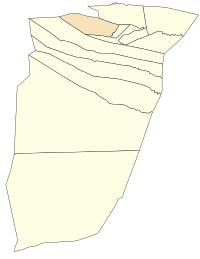 Location of Dhayet Bendhahoua commune within Ghardaïa Province | |
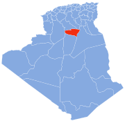
 Dhayet Bendhahoua Location of Dhayet Bendhahoua within Algeria | |
| Coordinates: 32°32′13″N 3°36′20″E | |
| Country | |
| Province | Ghardaïa Province |
| District | Dhayet Bendhahoua District (coextensive) |
| Elevation | 529 m (1,736 ft) |
| Population (2008)[1] | |
| • Total | 12,643 |
| Time zone | UTC+1 (CET) |
Geography
Dhayet Bendhahoua lies on the banks of the Wadi Mzab, an intermittent river in the M'zab valley, upstream of Ghardaïa. The area has been listed as a UNESCO World Heritage Site.[4]
Transportation
Dhayet Bendhahoua is connected to Ghardaïa by the regional road W147, which loops from Ghardaïa northwest to the town and then back east to the N1 highway. The N1 highway, part of the Trans-Sahara Highway, leads north to Laghouat and south to In Salah.
Education
4.6% of the population has a tertiary education, and another 16.7% has completed secondary education.[5] The overall literacy rate is 80.5%, and is 85.5% among males and 75.2% among females.[6]
Localities
The commune of Dhayet Bendhahoua is composed of one locality:[2]
- Village de Dayet Ben Dahoua et la Palmeraie
References
- "Population: Ghardaïa Wilaya" (PDF) (in French). Office National des Statistiques Algérie. Archived from the original (PDF) on 16 May 2013. Retrieved 13 February 2013.
- "Décret n° 84-365, fixant la composition, la consistance et les limites territoriale des communes. Wilaya d'El Oued" (PDF) (in French). Journal officiel de la République Algérienne. 19 December 1984. p. 1578. Archived from the original (PDF) on 2011-06-05. Retrieved 2 March 2013.
- "Algeria Communes". Statoids. Retrieved 9 March 2013.
- "M'Zab Valley". UNESCO World Heritage Centre. Retrieved 13 February 2013.
- "Structure relative de la population résidente des ménages ordinaires et collectifs âgée de 6 ans et plus selon le niveau d'instruction et la commune de résidence" (PDF) (in French). Office National des Statistiques Algérie. Archived from the original (PDF) on 16 May 2013. Retrieved 13 February 2013.
- "Taux d'analphabétisme et taux d'alphabétisation de la population âgée de 15 ans et plus, selon le sexe et la commune de résidence " (PDF) (in French). Office National des Statistiques Algérie. Archived from the original (PDF) on 16 May 2013. Retrieved 13 February 2013.
Places adjacent to Dhayet Bendhahoua | ||||||||||||||||
|---|---|---|---|---|---|---|---|---|---|---|---|---|---|---|---|---|
| ||||||||||||||||
Capital: Ghardaïa | ||
| Ghardaïa District |
|  |
| Bérianne District |
| |
| Bounoura District |
| |
| Dhayat Ben Dhahoua District | ||
| El Guerrara District |
| |
| El Ménia District |
| |
| Mansourah District |
| |
| Métlili District |
| |
| Zelfana District | ||
Другой контент может иметь иную лицензию. Перед использованием материалов сайта WikiSort.org внимательно изучите правила лицензирования конкретных элементов наполнения сайта.
WikiSort.org - проект по пересортировке и дополнению контента Википедии