world.wikisort.org - Russia
Ukhta (Russian: Ухта́; Komi: Уква, Ukva) is an important industrial town in the Komi Republic of Russia. Population: 99,591 (2010 Census);[2] 103,340 (2002 Census);[8] 110,548 (1989 Census).[9]
Ukhta
Ухта | |
|---|---|
Town[1] | |
| Other transcription(s) | |
| • Komi | Уква |
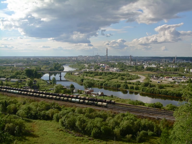 View of Ukhta from Vetlosyan | |
 Coat of arms | |
Location of Ukhta  | |
 Ukhta Location of Ukhta  Ukhta Ukhta (Komi Republic) | |
| Coordinates: 63°34′N 53°42′E | |
| Country | Russia |
| Federal subject | Komi Republic[1] |
| Founded | 1929 |
| Town status since | 1943 |
| Government | |
| • Mayor | Grigory Konenkov |
| Elevation | 100 m (300 ft) |
| Population | |
| • Total | 99,591 |
| • Estimate (2018)[3] | 97,087 (−2.5%) |
| • Rank | 166th in 2010 |
Administrative status | |
| • Subordinated to | town of republic significance of Ukhta[1] |
| • Capital of | town of republic significance of Ukhta[1] |
Municipal status | |
| • Urban okrug | Ukhta Urban Okrug[4] |
| • Capital of | Ukhta Urban Okrug[4] |
| Time zone | UTC+3 (MSK |
| Postal code(s)[6] | 169300 |
| Dialing code(s) | +7 8216[7] |
| OKTMO ID | 87725000001 |
| Website | mouhta |
It was previously known as Chibyu (until 1939).
History
Oil springs along the Ukhta River were already known in the 17th century. In the mid-19th century, industrialist M. K. Sidorov started to drill for oil in this area. It was one of the first oil wells in Russia. There was homecraft oil-field in 1920–1921 in Ukhta. Lying on the river of the same name, the settlement was founded as the village of Chibyu in 1929, but in 1939 it was renamed Ukhta.[citation needed] It was granted town status in 1943 when it was linked to the Pechora Railway.[citation needed] To the east of the town is Sosnogorsk, and to the southwest—Yarega. In addition to its rail link, Ukhta also has an airport.
The town expanded in the 1940s and 1950s by use of political prisoners' forced labor (see: gulag).
Administrative and municipal status
Within the framework of administrative divisions, it is, together with four urban-type settlements (Borovoy, Vodny, Shudayag, and Yarega) and thirteen rural localities, incorporated as the town of republic significance of Ukhta—an administrative unit with the status equal to that of the districts.[1] As a municipal division, the town of republic significance of Ukhta is incorporated as Ukhta Urban Okrug.[4]
Economy
Ukhta lies within the Timan-Pechora Basin, an important oil and gas-producing region. The oilfields lie just south of the city. Some of the Ukhta's oil is refined locally; most, however, is piped to oil refineries between St. Petersburg and Moscow. There have been a few gas pipeline explosions at a distance of Eight kilometres (five miles) from the town since the 1990s.
Climate
Ukhta has a continental subarctic climate[10] (Dfc) with long, cold winters and short, warm summers. Compared with areas at a similar latitude in Siberia, winters are less extreme, but still much longer than summer and bitterly cold by European standards.
| Climate data for Ukhta | |||||||||||||
|---|---|---|---|---|---|---|---|---|---|---|---|---|---|
| Month | Jan | Feb | Mar | Apr | May | Jun | Jul | Aug | Sep | Oct | Nov | Dec | Year |
| Record high °C (°F) | 2.5 (36.5) |
3.0 (37.4) |
13.0 (55.4) |
23.8 (74.8) |
30.1 (86.2) |
33.5 (92.3) |
35.2 (95.4) |
32.5 (90.5) |
27.4 (81.3) |
20.0 (68.0) |
8.2 (46.8) |
3.6 (38.5) |
35.2 (95.4) |
| Average high °C (°F) | −13.1 (8.4) |
−10.9 (12.4) |
−2.4 (27.7) |
4.6 (40.3) |
12.0 (53.6) |
19.0 (66.2) |
22.1 (71.8) |
17.3 (63.1) |
10.7 (51.3) |
2.8 (37.0) |
−6.0 (21.2) |
−10.6 (12.9) |
3.8 (38.8) |
| Daily mean °C (°F) | −16.5 (2.3) |
−14.7 (5.5) |
−6.8 (19.8) |
−0.5 (31.1) |
6.3 (43.3) |
13.3 (55.9) |
16.5 (61.7) |
12.4 (54.3) |
6.9 (44.4) |
0.4 (32.7) |
−8.9 (16.0) |
−13.8 (7.2) |
−0.5 (31.1) |
| Average low °C (°F) | −20.0 (−4.0) |
−18.1 (−0.6) |
−10.9 (12.4) |
−5.0 (23.0) |
1.5 (34.7) |
8.2 (46.8) |
11.6 (52.9) |
8.4 (47.1) |
4.0 (39.2) |
−1.8 (28.8) |
−11.3 (11.7) |
−17.2 (1.0) |
−4.2 (24.4) |
| Record low °C (°F) | −48.5 (−55.3) |
−43.9 (−47.0) |
−39.2 (−38.6) |
−28.4 (−19.1) |
−16.9 (1.6) |
−4.2 (24.4) |
−0.4 (31.3) |
−3.9 (25.0) |
−8.8 (16.2) |
−26.4 (−15.5) |
−37.8 (−36.0) |
−49.0 (−56.2) |
−49.0 (−56.2) |
| Average precipitation mm (inches) | 32 (1.3) |
26 (1.0) |
29 (1.1) |
28 (1.1) |
44 (1.7) |
66 (2.6) |
71 (2.8) |
69 (2.7) |
54 (2.1) |
55 (2.2) |
40 (1.6) |
39 (1.5) |
553 (21.8) |
| Source: Weatherbase[11] | |||||||||||||
Notable people
- Roman Abramovich, Russian businessman
- Dmitri Aliev, Olympic figure skater
- Aleksandr Chupriyan, Minister of Emergency Situations
- Olga Fonda, actress
- Sergei Kapustin, hockey player
- Viktor Alexandrovič Lyapkalo, painter
- Eduard Rossel, Governor of Sverdlovsk Oblast
- Yulia Samoilova, Russian singer
- Alexander Sukhorukov, Olympic swimmer
- Arsen Pavlov, Former commander of Donetsk Seperatist militia "Sparta Battalion"
References
Notes
- Law #16-RZ
- Russian Federal State Statistics Service (2011). Всероссийская перепись населения 2010 года. Том 1 [2010 All-Russian Population Census, vol. 1]. Всероссийская перепись населения 2010 года [2010 All-Russia Population Census] (in Russian). Federal State Statistics Service.
- "26. Численность постоянного населения Российской Федерации по муниципальным образованиям на 1 января 2018 года". Federal State Statistics Service. Retrieved January 23, 2019.
- Law #11-RZ
- "Об исчислении времени". Официальный интернет-портал правовой информации (in Russian). June 3, 2011. Retrieved January 19, 2019.
- Почта России. Информационно-вычислительный центр ОАСУ РПО. (Russian Post). Поиск объектов почтовой связи (Postal Objects Search) (in Russian)
- "dialing codes ref".
- Russian Federal State Statistics Service (May 21, 2004). Численность населения России, субъектов Российской Федерации в составе федеральных округов, районов, городских поселений, сельских населённых пунктов – районных центров и сельских населённых пунктов с населением 3 тысячи и более человек [Population of Russia, Its Federal Districts, Federal Subjects, Districts, Urban Localities, Rural Localities—Administrative Centers, and Rural Localities with Population of Over 3,000] (XLS). Всероссийская перепись населения 2002 года [All-Russia Population Census of 2002] (in Russian).
- Всесоюзная перепись населения 1989 г. Численность наличного населения союзных и автономных республик, автономных областей и округов, краёв, областей, районов, городских поселений и сёл-райцентров [All Union Population Census of 1989: Present Population of Union and Autonomous Republics, Autonomous Oblasts and Okrugs, Krais, Oblasts, Districts, Urban Settlements, and Villages Serving as District Administrative Centers]. Всесоюзная перепись населения 1989 года [All-Union Population Census of 1989] (in Russian). Институт демографии Национального исследовательского университета: Высшая школа экономики [Institute of Demography at the National Research University: Higher School of Economics]. 1989 – via Demoscope Weekly.
- "Ukhta, Russia Climate Summary". Weatherbase. Retrieved March 23, 2015.
- "Ukhta, Russia Travel Weather Averages". Weatherbase. 2013. Retrieved on February 19, 2013.
Sources
- Государственный Совет Республики Коми. Закон №13-РЗ от 6 марта 2006 г. «Об административно-территориальном устройстве Республики Коми», в ред. Закона №171-РЗ от 26 декабря 2014 г. «Об упразднении населённого пункта Верхняя Седка, расположенного на территории Прилузского района Республики Коми, и внесении в связи с этим изменений в некоторые Законы Республики Коми». Вступил в силу со дня официального опубликования. Опубликован: "Республика", №44, 16 марта 2006 г. (State Council of the Komi Republic. Law #13-RZ of March 6, 2006 On the Administrative-Territorial Structure of the Komi Republic, as amended by the Law #171-RZ of December 26, 2014 On Abolishing the Inhabited Locality of Verkhnyaya Sedka Located on the Territory of Priluzsky District of the Komi Republic, and on Amending Various Laws of the Komi Republic Accordingly. Effective as of the official publication date.).
- Государственный Совет Республики Коми. Закон №11-РЗ от 5 марта 2005 г. «О территориальной организации местного самоуправления в Республике Коми», в ред. Закона №171-РЗ от 26 декабря 2014 г. «Об упразднении населённого пункта Верхняя Седка, расположенного на территории Прилузского района Республики Коми, и внесении в связи с этим изменений в некоторые Законы Республики Коми». Вступил в силу 1 апреля 2005 г.. Опубликован: "Республика", №44–45, 17 марта 2005 г. (State Council of the Komi Republic. Law #11-RZ of March 5, 2005 On the Territorial Organization of the Local Self-Government in the Komi Republic, as amended by the Law #171-RZ of December 26, 2014 On Abolishing the Inhabited Locality of Verkhnyaya Sedka Located on the Territory of Priluzsky District of the Komi Republic, and on Amending Various Laws of the Komi Republic Accordingly. Effective as of April 1, 2005.).
External links
- Official website of Ukhta (in Russian)
- Unofficial website of Ukhta (in Russian)
- Pictures of Ukhta Archived March 16, 2008, at the Wayback Machine
- Website of Leonid Tomov. Information about Ukhta (in Russian)
Administrative divisions of the Komi Republic | |||
|---|---|---|---|
Capital: Syktyvkar • Rural localities | |||
| Administrative districts | |||
| Cities and towns | |||
| Urban-type settlements | |||
Authority control | |
|---|---|
| General | |
| National libraries | |
| Other |
|
На других языках
[de] Uchta
Uchta (russisch Ухта, [.mw-parser-output .IPA a{text-decoration:none}uxˈta]; Komi Уква, wiss. Transliteration Ukva, auch Ukwa transkribiert) ist eine Stadt in der Republik Komi im Nordwesten Russlands, am Fluss Uchta. Sie hat 99.591 Einwohner (Stand 14. Oktober 2010).[1]- [en] Ukhta
[es] Ujtá
Ujtá (en ruso: Ухта, Ujta; en komi: Уква, Ukvá) es una ciudad de la República de Komi, en el noroeste de la Federación Rusa. Se encuentra a orillas del río homónimo y a 325 km de la capital, Syktyvkar. Su población es de 127.000 habitantes (2006),[1] la mayoría rusos, ucranianos o del Cáucaso. La ciudad es predominantemente industrial. Ujtá está dentro de una región importante que produce gas y petróleo. Los yacimientos petrolíferos están al sur de la ciudad. Parte de este petróleo de Ujtá es refinado en la zona, sin embargo, la mayoría se destina a refinerías de San Petersburgo y Moscú.[ru] Ухта
Ухта́[3] (коми Уква) — город (с 1943 года) в Республике Коми Российской Федерации. Образует городской округ «Ухта».Другой контент может иметь иную лицензию. Перед использованием материалов сайта WikiSort.org внимательно изучите правила лицензирования конкретных элементов наполнения сайта.
WikiSort.org - проект по пересортировке и дополнению контента Википедии