world.wikisort.org - France
Sartène (French: [saʁtɛn]; Corsican: Sartè [sarˈtɛ]; Italian: Sartena [sarˈtɛːna] or Sartene [sarˈtɛːne][3][4]) is a commune in the department of Corse-du-Sud on the island of Corsica, France.
This article may be expanded with text translated from the corresponding article in Corsican. (January 2009) Click [show] for important translation instructions.
|
Sartène
| |
|---|---|
Subprefecture and commune | |
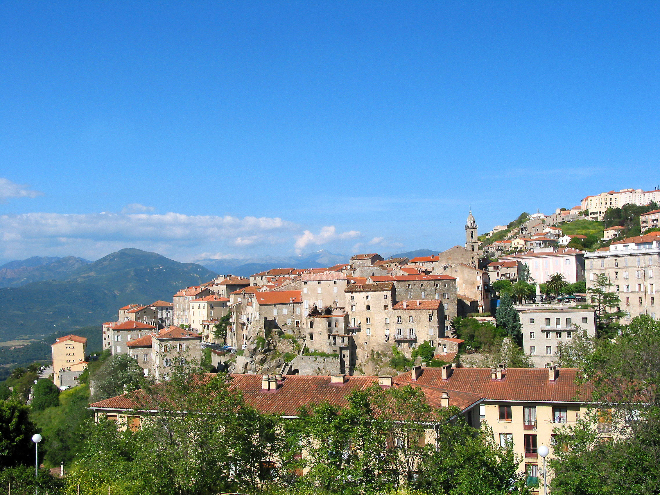 A general view of Sartène | |
 Coat of arms | |
Location of Sartène  | |
 Sartène  Sartène | |
| Coordinates: 41°37′18″N 8°58′27″E | |
| Country | France |
| Region | Corsica |
| Department | Corse-du-Sud |
| Arrondissement | Sartène |
| Canton | Sartenais-Valinco |
| Government | |
| • Mayor (2020–2026) | Paul Quilichini[1] |
| Area 1 | 200.4 km2 (77.4 sq mi) |
| Population | 3,248 |
| • Density | 16/km2 (42/sq mi) |
| Time zone | UTC+01:00 (CET) |
| • Summer (DST) | UTC+02:00 (CEST) |
| INSEE/Postal code | 2A272 /20100 |
| Elevation | 0–1,320 m (0–4,331 ft) (avg. 330 m or 1,080 ft) |
| 1 French Land Register data, which excludes lakes, ponds, glaciers > 1 km2 (0.386 sq mi or 247 acres) and river estuaries. | |
Its history dates back to medieval times and granite buildings from the early 16th century still line some of the streets. One of the main incidents in the town's history was an attack by pirates from Algiers in 1583, after which 400 people were taken away. These attacks continued into the 18th century.

The town is centred on the Place de la Liberation (previously the Place Porta), at the edge of which is the church of Sainte Marie. The town allows good views across the valley. Sartène wine is appreciated by wine connoisseurs for its good quality.
Sartène has given its name to one of the southern Corsican dialects a variety of which is the Gallurese spoken in North Sardinia.
Geography
Climate
Sartène has a mediterranean climate (Köppen climate classification Csa). The average annual temperature in Sartène is 15.8 °C (60.4 °F). The average annual rainfall is 732.1 mm (28.82 in) with November as the wettest month. The temperatures are highest on average in August, at around 23.9 °C (75.0 °F), and lowest in February, at around 8.9 °C (48.0 °F). The highest temperature ever recorded in Sartène was 43.4 °C (110.1 °F) on 23 July 2009; the coldest temperature ever recorded was −4.8 °C (23.4 °F) on 1 February 1999.
| Climate data for Sartène (1991–2020 averages, extremes 1996−present) | |||||||||||||
|---|---|---|---|---|---|---|---|---|---|---|---|---|---|
| Month | Jan | Feb | Mar | Apr | May | Jun | Jul | Aug | Sep | Oct | Nov | Dec | Year |
| Record high °C (°F) | 21.4 (70.5) |
23.5 (74.3) |
29.8 (85.6) |
31.1 (88.0) |
36.4 (97.5) |
40.1 (104.2) |
43.4 (110.1) |
42.1 (107.8) |
37.1 (98.8) |
34.7 (94.5) |
26.9 (80.4) |
22.4 (72.3) |
43.4 (110.1) |
| Average high °C (°F) | 13.6 (56.5) |
14.0 (57.2) |
16.4 (61.5) |
19.2 (66.6) |
23.3 (73.9) |
28.0 (82.4) |
30.6 (87.1) |
30.9 (87.6) |
26.7 (80.1) |
23.0 (73.4) |
17.9 (64.2) |
14.5 (58.1) |
21.5 (70.7) |
| Daily mean °C (°F) | 9.0 (48.2) |
8.9 (48.0) |
11.0 (51.8) |
13.6 (56.5) |
17.3 (63.1) |
21.3 (70.3) |
23.7 (74.7) |
23.9 (75.0) |
20.6 (69.1) |
17.5 (63.5) |
13.2 (55.8) |
10.0 (50.0) |
15.8 (60.4) |
| Average low °C (°F) | 4.3 (39.7) |
3.9 (39.0) |
5.6 (42.1) |
8.1 (46.6) |
11.3 (52.3) |
14.6 (58.3) |
16.7 (62.1) |
17.0 (62.6) |
14.5 (58.1) |
12.0 (53.6) |
8.5 (47.3) |
5.5 (41.9) |
10.2 (50.4) |
| Record low °C (°F) | −4.6 (23.7) |
−4.8 (23.4) |
−3.8 (25.2) |
−1.9 (28.6) |
3.9 (39.0) |
5.9 (42.6) |
8.6 (47.5) |
10.3 (50.5) |
7.0 (44.6) |
0.4 (32.7) |
−4.7 (23.5) |
−4.3 (24.3) |
−4.8 (23.4) |
| Average precipitation mm (inches) | 73.6 (2.90) |
58.2 (2.29) |
57.1 (2.25) |
54.9 (2.16) |
57.2 (2.25) |
29.6 (1.17) |
9.3 (0.37) |
18.1 (0.71) |
58.2 (2.29) |
88.8 (3.50) |
129.3 (5.09) |
97.8 (3.85) |
732.1 (28.82) |
| Average precipitation days (≥ 1.0 mm) | 8.9 | 8.1 | 7.6 | 7.3 | 5.8 | 3.3 | 1.1 | 2.2 | 5.6 | 7.0 | 10.9 | 9.3 | 76.9 |
| Source: Météo France[5] | |||||||||||||
Population
|
|
Sights
Genoese towers in the commune of Sartène:
- Torra di Roccapina
- Torra di Senetosa
- Torra di Tizzà
There are numerous archaeological sites in the commune or Sartène:
- A Figa
- Apazzu
- Cardiccia
- Casteddu di Puzzonu
- Cauria
- Funtanaccia
- Paddaghju
- Rinaghju
- Stantari
See also
References
- "Répertoire national des élus: les maires". data.gouv.fr, Plateforme ouverte des données publiques françaises (in French). 2 December 2020.
- "Populations légales 2019". The National Institute of Statistics and Economic Studies. 29 December 2021.
- Luciano Canepari. "Sartena". DiPI Online (in Italian). Retrieved 16 January 2021.
- Luciano Canepari. "Sartene". DiPI Online (in Italian). Retrieved 16 January 2021.
- "climate of Sartène 1991-2020" (PDF) (in French). Météo-France. Retrieved June 1, 2022.
External links
- A page on the history of the town
- Corsican Dolmens (in English and Italian)
Authority control | |
|---|---|
| General |
|
| National libraries | |
| Other |
|
This Corse-du-Sud geographical article is a stub. You can help Wikipedia by expanding it. |
На других языках
[de] Sartène
Sartène (korsisch Sartè) ist eine französische Gemeinde und die Hauptstadt des Sartenais auf Korsika. Sie hat 3248 Einwohner (Stand 1. Januar 2019) und eine Fläche von 200 km² und ist damit die größte der Insel.- [en] Sartène
[es] Sartène
Sartène (Sartè en idioma corso) es una comuna y población de Francia, en la región de Córcega, departamento de Córcega del Sur. Es la subprefectura del distrito y la cabecera del cantón de su nombre.[ru] Сартен
Сартен (фр. Sartène, корс. Sartè) — город и коммуна во Франции, на Корсике.Другой контент может иметь иную лицензию. Перед использованием материалов сайта WikiSort.org внимательно изучите правила лицензирования конкретных элементов наполнения сайта.
WikiSort.org - проект по пересортировке и дополнению контента Википедии