world.wikisort.org - Stati_Uniti_d'America
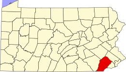
La contea di Chester (in inglese Chester County) è una contea dello Stato della Pennsylvania, negli Stati Uniti. La popolazione al censimento del 2010 era di 498.886 abitanti. Il capoluogo di contea è West Chester.
| Contea di Chester contea | ||
|---|---|---|
| ||
 | ||
| Localizzazione | ||
| Stato | ||
| Stato federato | ||
| Amministrazione | ||
| Capoluogo | West Chester | |
| Data di istituzione | 1862 | |
| Territorio | ||
| Coordinate del capoluogo | 39°57′31″N 75°36′18″W | |
| Superficie | 1 968 km² | |
| Abitanti | 498 886 (2010) | |
| Densità | 253,5 ab./km² | |
| Altre informazioni | ||
| Fuso orario | UTC-5 | |
| Cartografia | ||
 | ||
| Sito istituzionale | ||


Geografia fisica
La contea si trova nella parte sud-orientale della Pennsylvania al confine con il Delaware e il Maryland. L'U.S. Census Bureau certifica che l'estensione della contea è di 1.968 km², di cui 10 km² costituiti da acque interne.
Contee confinanti
- Contea di Berks - nord-est
- Contea di Montgomery - nord-est
- Contea di Delaware - est
- Contea di New Castle (Delaware) - sud-est
- Contea di Cecil (Maryland) - sud
- Contea di Lancaster - ovest
Storia
La Contea di Chester è una delle tre contee originarie della Pennsylvania, costituite il 24 agosto 1682 da William Penn. Deve il suo nome alla contea di Cheshire, in Inghilterra. Il suo territorio si è poi progressivamente ridotto con il distacco di contee di nuova formazione.
Suddivisione amministrativa

La contea è amministrativamente suddivisa in una city, 15 borough e 57 township. Vi sono inoltre 10 Census-designated place.
|
|
|
Census-designated places
|
|
|
Altri progetti
 Wikimedia Commons contiene immagini o altri file su contea di Chester
Collegamenti esterni
- (EN) Sito ufficiale, su chesco.org.
- (EN) Contea di Chester, su Enciclopedia Britannica, Encyclopædia Britannica, Inc.
- (EN) Contea di Chester, su Geographic Names Information System, USGS.
| Controllo di autorità | VIAF (EN) 153594807 · ISNI (EN) 0000 0004 4685 1433 · LCCN (EN) n79088894 · GND (DE) 10003081-6 · WorldCat Identities (EN) lccn-n79088894 |
|---|
На других языках
[de] Chester County (Pennsylvania)
Das Chester[3] [.mw-parser-output .IPA a{text-decoration:none}ˈtʃɛstɚ] County ist ein County im US-Bundesstaat Pennsylvania. Bei der Volkszählung im Jahr 2010 hatte das County 498.886 Einwohner und eine Bevölkerungsdichte von 254,8 Einwohnern pro Quadratkilometer. Der Verwaltungssitz (County Seat) ist West Chester.[4][en] Chester County, Pennsylvania
Chester County (Pennsylvania Dutch: Tscheschter Kaundi), colloquially known as Chesco, is a county in the southeastern part of the U.S. state of Pennsylvania. As of the 2020 census, the population was 534,413,[2] increasing by 7.1% from 498,886 in 2010.[3] The county seat and most populated municipality is West Chester.[4] Chester County was one of the three original Pennsylvania counties created by William Penn in 1682. It was named for Chester, England.[fr] Comté de Chester (Pennsylvanie)
Le comté de Chester est un comté américain de l'État de Pennsylvanie. Au recensement de 2000, le comté comptait 433 501 habitants. Il était l'un des trois comtés originels de la Pennsylvanie créée par William Penn, en 1682, et fut nommé d'après Cheshire en Angleterre. Le siège du comté se situe à West Chester.- [it] Contea di Chester (Pennsylvania)
[ru] Честер (округ, Пенсильвания)
Округ Честер (англ. Chester County) располагается в штате Пенсильвания, США. Официально образован в ноябре 1682 года. По состоянию на 2010 год, численность населения составляла 498 886 человека.Другой контент может иметь иную лицензию. Перед использованием материалов сайта WikiSort.org внимательно изучите правила лицензирования конкретных элементов наполнения сайта.
WikiSort.org - проект по пересортировке и дополнению контента Википедии