world.wikisort.org - USA
White Eagle is an unincorporated community in Kay County, Oklahoma, United States.
White Eagle, Oklahoma | |
|---|---|
Unincorporated community | |
 Ponca Tribe Sign in White Eagle | |
 White Eagle  White Eagle | |
| Coordinates: 36°36′30″N 97°04′34″W | |
| Country | United States |
| State | Oklahoma |
| County | Kay |
| Area | |
| • Total | 5.87 sq mi (15.20 km2) |
| • Land | 5.87 sq mi (15.20 km2) |
| • Water | 0.00 sq mi (0.00 km2) |
| Elevation | 948 ft (289 m) |
| Population (2020) | |
| • Total | 520 |
| • Density | 88.60/sq mi (34.21/km2) |
| Time zone | UTC-6 (Central (CST)) |
| • Summer (DST) | UTC-5 (CDT) |
| Area code | 580 |
| GNIS feature ID = 1102141[2] | 40-80750 |
White Eagle was named for the Ponca principal chief, White Eagle (ca. 1840-1914), who led the Ponca to their reservation in Indian Territory.[3] Other names for the town are Ponca, White Eagle Agency, and Whiteagle.[2]
Geography
White Eagle is located in southeastern Kay County, just east of the Salt Fork and approximately one and one quarter miles west-northwest of the confluence of the Salt Fork with the Arkansas River. The community is on U.S. Route 177, five miles south of Ponca City.[4]
Demographics
| Historical population | |||
|---|---|---|---|
| Census | Pop. | %± | |
| 2020 | 520 | — | |
| U.S. Decennial Census[5] | |||
Politics
White Eagle is the headquarters for the Ponca Tribe of Indians of Oklahoma.[6]
Notable person
- Paladine Roye, Ponca painter, 1946-2001
References
- "ArcGIS REST Services Directory". United States Census Bureau. Retrieved September 20, 2022.
- U.S. Geological Survey Geographic Names Information System: White Eagle, Oklahoma
- Johansen, Bruce E. White Eagle. Oklahoma Historical Society's Encyclopedia of Oklahoma History & Culture. 2009 (15 August 2009)
- Ponca City SE, OK, 7.5 Minute Topographic Quadrangle, USGS, 1968
- "Census of Population and Housing". Census.gov. Retrieved June 4, 2016.
- Van de Logt, Mark. Ponca. Oklahoma Historical Society's Encyclopedia of Oklahoma History & Culture. 2009 (15 August 2009)
Municipalities and communities of Kay County, Oklahoma, United States | ||
|---|---|---|
County seat: Newkirk | ||
| Cities | 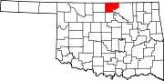 | |
| Towns | ||
| CDPs | ||
| Other communities |
| |
| Ghost towns | ||
| ||
Текст в блоке "Читать" взят с сайта "Википедия" и доступен по лицензии Creative Commons Attribution-ShareAlike; в отдельных случаях могут действовать дополнительные условия.
Другой контент может иметь иную лицензию. Перед использованием материалов сайта WikiSort.org внимательно изучите правила лицензирования конкретных элементов наполнения сайта.
Другой контент может иметь иную лицензию. Перед использованием материалов сайта WikiSort.org внимательно изучите правила лицензирования конкретных элементов наполнения сайта.
2019-2025
WikiSort.org - проект по пересортировке и дополнению контента Википедии
WikiSort.org - проект по пересортировке и дополнению контента Википедии