world.wikisort.org - USA
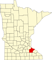
Wacouta is an unincorporated community in Wacouta Township, Goodhue County, Minnesota, United States.
Wacouta | |
|---|---|
Unincorporated community | |
 Wacouta  Wacouta | |
| Coordinates: 44°32′42″N 92°26′06″W | |
| Country | United States |
| State | Minnesota |
| County | Goodhue |
| Township | Wacouta |
| Elevation | 715 ft (218 m) |
| Time zone | UTC-6 (Central (CST)) |
| • Summer (DST) | UTC-5 (CDT) |
| ZIP code | 55066 |
| Area code(s) | 651 |
| GNIS feature ID | 653706[1] |
The community is located southeast of Red Wing along Highways 61 and 63. Bullard Creek flows through the community, with the Mississippi River and Lake Pepin located nearby.
Nearby places include Red Wing, Frontenac, Hay Creek, and Lake City.
References
- "Wacouta, Minnesota". Geographic Names Information System. United States Geological Survey, United States Department of the Interior.
Текст в блоке "Читать" взят с сайта "Википедия" и доступен по лицензии Creative Commons Attribution-ShareAlike; в отдельных случаях могут действовать дополнительные условия.
Другой контент может иметь иную лицензию. Перед использованием материалов сайта WikiSort.org внимательно изучите правила лицензирования конкретных элементов наполнения сайта.
Другой контент может иметь иную лицензию. Перед использованием материалов сайта WikiSort.org внимательно изучите правила лицензирования конкретных элементов наполнения сайта.
2019-2025
WikiSort.org - проект по пересортировке и дополнению контента Википедии
WikiSort.org - проект по пересортировке и дополнению контента Википедии
