world.wikisort.org - USA
Unityville is an unincorporated community in McCook County, South Dakota, United States. Unityville is 6.2 miles (10.0 km) north-northwest of Salem.
Unityville, South Dakota | |
|---|---|
Unincorporated community | |
 Unityville, South Dakota | |
| Coordinates: 43°48′05″N 97°27′09″W | |
| Country | United States |
| State | South Dakota |
| County | McCook |
| Elevation | 1,529 ft (466 m) |
| Time zone | UTC-6 (Central (CST)) |
| • Summer (DST) | UTC-5 (CDT) |
| Area code(s) | 605 |
| GNIS feature ID | 1258713[1] |
Unityville was originally called Stark, and under the latter name was laid out in 1907 by J. F. Stark, and named for him.[2]
References
- "Unityville". Geographic Names Information System. United States Geological Survey.
- Federal Writers' Project (1940). South Dakota place-names, v.1-3. University of South Dakota. p. 63.
Municipalities and communities of McCook County, South Dakota, United States | ||
|---|---|---|
County seat: Salem | ||
| Cities | 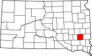 | |
| CDPs |
| |
| Unincorporated community | ||
| ||
This South Dakota state location article is a stub. You can help Wikipedia by expanding it. |
Текст в блоке "Читать" взят с сайта "Википедия" и доступен по лицензии Creative Commons Attribution-ShareAlike; в отдельных случаях могут действовать дополнительные условия.
Другой контент может иметь иную лицензию. Перед использованием материалов сайта WikiSort.org внимательно изучите правила лицензирования конкретных элементов наполнения сайта.
Другой контент может иметь иную лицензию. Перед использованием материалов сайта WikiSort.org внимательно изучите правила лицензирования конкретных элементов наполнения сайта.
2019-2026
WikiSort.org - проект по пересортировке и дополнению контента Википедии
WikiSort.org - проект по пересортировке и дополнению контента Википедии