world.wikisort.org - USA
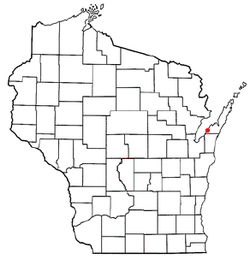
Union is a town in Door County, Wisconsin, United States. The population was 880 at the 2000 census. The unincorporated communities of Shoemaker Point and Namur are located in the town.[3][4]
Union, Wisconsin | |
|---|---|
Town | |
 Town hall | |
 Location of Union, Wisconsin | |
| Coordinates: 44°42′58″N 87°41′29″W | |
| Country | |
| State | |
| County | Door |
| Area | |
| • Total | 35.9 sq mi (93.0 km2) |
| • Land | 21.2 sq mi (54.8 km2) |
| • Water | 14.7 sq mi (38.2 km2) |
| Elevation | 597 ft (182 m) |
| Population (2000) | |
| • Total | 880 |
| • Density | 41.6/sq mi (16.0/km2) |
| Time zone | UTC−06:00 (Central (CST)) |
| • Summer (DST) | UTC−05:00 (CDT) |
| Area code(s) | 920 |
| FIPS code | 55-81525[2] |
| GNIS feature ID | 1584310[1] |
| Website | https://sites.google.com/site/townofuniondoor |
Geography

According to the United States Census Bureau, the town has a total area of 35.9 square miles (93.0 km2), of which, 21.2 square miles (54.8 km2) of it is land and 14.7 square miles (38.2 km2) of it (41.02%) is water.
The Heyrman I archeological site was used by Native Americans for camping and stoneworking purposes. It is located on a sandy ridge parallel to Highway 57 to the north of Cedar Road.[5]
The Vandermissen Brickworks was the first brickmaking site ever excavated for archeological purposes in the state.[6]
Demographics
As of the census[2] of 2000, there were 880 people, 335 households, and 259 families residing in the town. The population density was 41.6 people per square mile (16.0/km2). There were 512 housing units at an average density of 24.2 per square mile (9.3/km2). The racial makeup of the town was 99.20% White, 0.34% African American, 0.23% Asian, and 0.23% from two or more races. Hispanic or Latino of any race were 0.45% of the population.
There were 335 households, out of which 31.9% had children under the age of 18 living with them, 69.0% were married couples living together, 5.4% had a female householder with no husband present, and 22.4% were non-families. 17.9% of all households were made up of individuals, and 6.6% had someone living alone who was 65 years of age or older. The average household size was 2.63 and the average family size was 3.00.
In the town, the population was spread out, with 26.1% under the age of 18, 6.8% from 18 to 24, 27.6% from 25 to 44, 27.0% from 45 to 64, and 12.4% who were 65 years of age or older. The median age was 38 years. For every 100 females, there were 102.8 males. For every 100 females age 18 and over, there were 105.7 males.
The median income for a household in the town was $47,604, and the median income for a family was $51,917. Males had a median income of $32,250 versus $21,875 for females. The per capita income for the town was $19,372. About 4.1% of families and 5.1% of the population were below the poverty line, including 2.4% of those under age 18 and 7.0% of those age 65 or over.
Most Belgian American towns
Union, Door County, Wisconsin is the most Belgian American community in the United States, by proportion of residents.[7]
- Union, Door County, Wisconsin: 49%[8]
- Red River, Wisconsin (Kewaunee County): 47%[9]
- Brussels, Wisconsin (Door County): 36.4% (composed of "Brussels community" & "Namur Community")[10]
- Lincoln, Kewaunee County, Wisconsin: 35.4%[11]
- Green Bay (town), Wisconsin (Brown County): 31.8%[12]
Climate
| ||||||||||||||||||||||||||||||||||||||||||||||||||||||||||||||||||||||||||||||||||||||||||||||||||||||||||||||||||||||||||||
References
- "US Board on Geographic Names". United States Geological Survey. 2007-10-25. Retrieved 2008-01-31.
- "U.S. Census website". United States Census Bureau. Retrieved 2008-01-31.
- Map of the Town of Union, Door County Land Use Services Department, August 16, 2017 (Archived April 9, 2019)
- "Door county map" (PDF). Wisconsin DOT. Retrieved 2 December 2017.
- Expecting the Unexpected: Archaeological Investigations at the Heyrman I Site (DR243), Door County,. Wisconsin by Toni A. Revane and John D. Richards, University of Wisconsin-Milwaukee UWM Archaeological Research Laboratory, Historic Resource Management Services Report of Investigations No. 157, part of "Transportation Archaeology on the Door Peninsula: Progress and Prospects 1992 - 2004", page 10 (page 26 of the pdf)
- After the Great Fire: Archaeology at the Vandermissen Brickworks by Patricia B. Richards, University of Wisconsin-Milwaukee UWM Archaeological Research Laboratory, Historic Resource Management Services Report of Investigations No. 157, part of "Transportation Archaeology on the Door Peninsula: Progress and Prospects 1992 - 2004", pages 103 and following (pdf pages 119 and following)
- Belgian Communities ePodunk (Archived February 25, 2019); the town of Union is omitted from the list
- http://www.epodunk.com, Union, WI, epodunk.com (Archived February 23, 2019)
- Red River, WI, epodunk.com (Archived September 20, 2017)
- Brussels, WI, epodunk.com (Archived September 21, 2017)
- Lincoln, WI, epodunk.com (Archived September 21, 2017)
- Green Bay (town), WI, epodunk.com (Archived September 21, 2017)
- "NASA EarthData Search". NASA. Retrieved 30 January 2016.
Другой контент может иметь иную лицензию. Перед использованием материалов сайта WikiSort.org внимательно изучите правила лицензирования конкретных элементов наполнения сайта.
WikiSort.org - проект по пересортировке и дополнению контента Википедии
