world.wikisort.org - USA
Unaka is an unincorporated community in Cherokee County, North Carolina, United States. Unaka is located in the Nantahala National Forest, 9.6 miles (15.4 km) northwest of Murphy. Unaka had a post office until it closed on February 15, 1986.[2][3] Unaka is a name derived from a Cherokee word meaning "white", which referred to the appearance of low-lying clouds and fog over the Unicoi Mountains.[4]
Unaka, North Carolina | |
|---|---|
Unincorporated community | |
 Unaka  Unaka | |
| Coordinates: 35°11′43″N 84°08′30″W | |
| Country | United States |
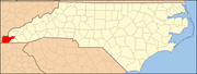
| State | North Carolina |
| County | Cherokee |
| Elevation | 1,644 ft (501 m) |
| Time zone | UTC-5 (Eastern (EST)) |
| • Summer (DST) | UTC-4 (EDT) |
| Area code | 828 |
| GNIS feature ID | 1023032[1] |
References
- "Unaka". Geographic Names Information System. United States Geological Survey, United States Department of the Interior.
- United States Postal Service (2012). "USPS - Look Up a ZIP Code". Retrieved 2012-02-15.
- "Postmaster Finder - Post Offices by ZIP Code". United States Postal Service. Retrieved March 16, 2013.
- "Community Backstory". Cherokee County Chamber of Commerce. Archived from the original on 3 July 2019. Retrieved 3 July 2019.
Municipalities and communities of Cherokee County, North Carolina, United States | ||
|---|---|---|
County seat: Murphy | ||
| Towns |
|  |
| CDP | ||
| Other communities | ||
| Indian reservation | ||
| Footnotes | ‡This populated place also has portions in an adjacent county or counties | |
| ||
Текст в блоке "Читать" взят с сайта "Википедия" и доступен по лицензии Creative Commons Attribution-ShareAlike; в отдельных случаях могут действовать дополнительные условия.
Другой контент может иметь иную лицензию. Перед использованием материалов сайта WikiSort.org внимательно изучите правила лицензирования конкретных элементов наполнения сайта.
Другой контент может иметь иную лицензию. Перед использованием материалов сайта WikiSort.org внимательно изучите правила лицензирования конкретных элементов наполнения сайта.
2019-2025
WikiSort.org - проект по пересортировке и дополнению контента Википедии
WikiSort.org - проект по пересортировке и дополнению контента Википедии