world.wikisort.org - USA
Turck is a unincorporated community in Cherokee County, Kansas, United States. Its elevation is 932 feet.[1]
Turck, Kansas | |
|---|---|
Unincorporated community | |
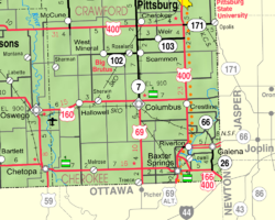 KDOT map of Cherokee County (legend) | |
 Turck  Turck | |
| Coordinates: 37°15′50″N 94°49′55″W[1] | |
| Country | United States |
| State | Kansas |
| County | Cherokee |
| Elevation | 932 ft (284 m) |
| Time zone | UTC-6 (CST) |
| • Summer (DST) | UTC-5 (CDT) |
| Area code | 620 |
| FIPS code | 20-71650 [1] |
| GNIS ID | 484451 [1] |
History
Turck had a post office from 1889 until 1891.[2]
References
- Geographic Names Information System (GNIS) details for Turck, Kansas; United States Geological Survey (USGS); October 13, 1978.
- "Kansas Post Offices, 1828-1961, page 2". Kansas Historical Society. Retrieved 6 June 2014.
Further reading
External links
Municipalities and communities of Cherokee County, Kansas, United States | ||
|---|---|---|
County seat: Columbus | ||
| Cities |  | |
| Unincorporated communities | ||
| Ghost towns | ||
| Townships | ||
| Footnotes | †This community is designated a Census-Designated Place (CDP) by the United States Census Bureau. ‡This community also has portions in an adjacent county or counties. | |
| ||
Текст в блоке "Читать" взят с сайта "Википедия" и доступен по лицензии Creative Commons Attribution-ShareAlike; в отдельных случаях могут действовать дополнительные условия.
Другой контент может иметь иную лицензию. Перед использованием материалов сайта WikiSort.org внимательно изучите правила лицензирования конкретных элементов наполнения сайта.
Другой контент может иметь иную лицензию. Перед использованием материалов сайта WikiSort.org внимательно изучите правила лицензирования конкретных элементов наполнения сайта.
2019-2026
WikiSort.org - проект по пересортировке и дополнению контента Википедии
WikiSort.org - проект по пересортировке и дополнению контента Википедии