 Tuba City Chapter House of the Navajo Nation.
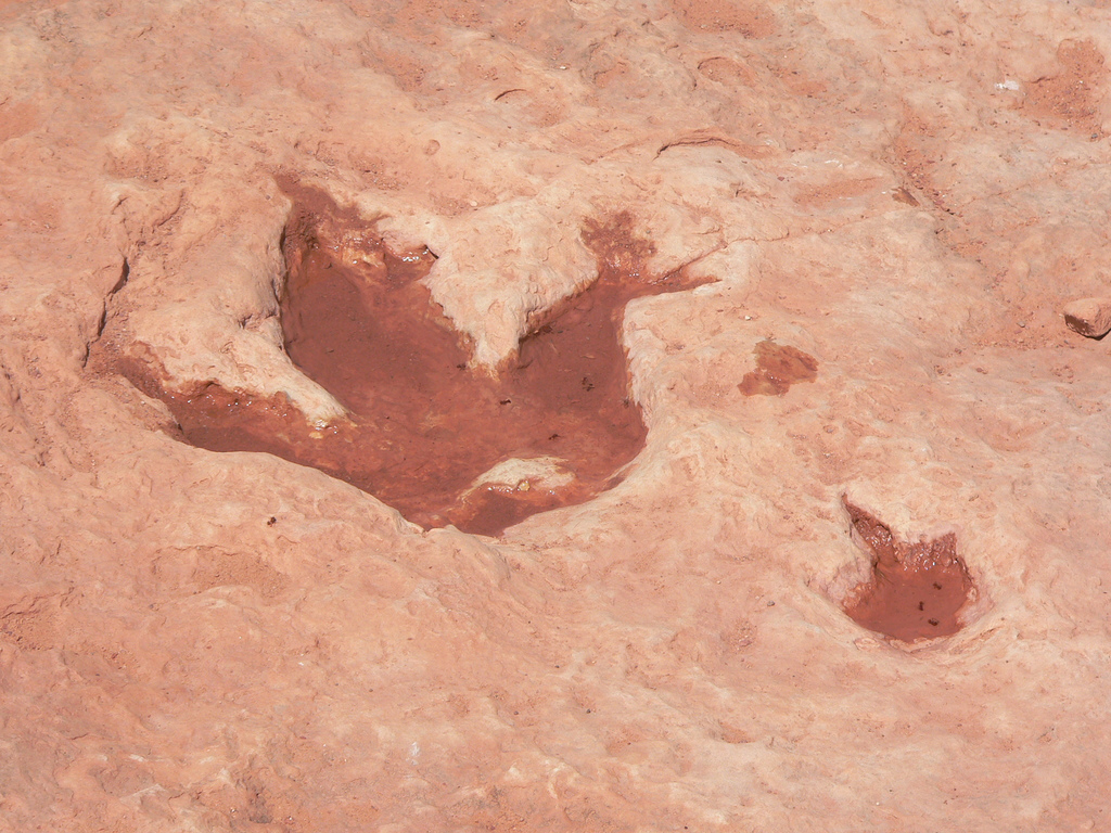
 Dinosaur track in Tuba City
 Coal Mine Canyon at sunset
 Moonrise at Coal Mine Canyon
world.wikisort.org - USA
Tuba City (Navajo: Tó Naneesdizí) is an unincorporated town in Coconino County, Arizona, on the Navajo Nation, United States. It is the second-largest community in Coconino County. The population of the census-designated place (CDP) was 8,611 at the 2010 census.[4]
Tuba City, Arizona
Tó Naneesdizí | |
|---|---|
Unincorporated town CDP | |
 Tuba Trading Post built in 1905 | |
 Location in Coconino County and the state of Arizona | |
 Tuba City Location in Arizona#Location in the United States  Tuba City Tuba City (the United States) | |
| Coordinates: 36°08′06″N 111°14′24″W | |
| Country | |
| State | |
| County | Coconino |
| Government | |
| • Type | Navajo chapter |
| • Chapter president | Gerald Keetso |
| Area | |
| • Total | 8.97 sq mi (23.24 km2) |
| • Land | 8.97 sq mi (23.24 km2) |
| • Water | 0.00 sq mi (0.00 km2) |
| Elevation | 4,961 ft (1,512 m) |
| Population (2020) | |
| • Total | 8,072 |
| • Estimate (2016)[3] | N/A |
| Time zone | UTC-7 (MST) |
| • Summer (DST) | UTC-6 (MDT) |
| ZIP code | 86045 |
| Area code | 928 |
| FIPS code | 04-76010 |
| GNIS feature ID | 12802[2] |
It is the most populous community within the Navajo Nation, slightly larger than Shiprock, New Mexico, and the site of the headquarters of the Western Navajo Agency. The Hopi village of Moenkopi lies directly to its southeast, and Hopi also live in the city.
European Americans named the town in honor of chief Tuuvi, a Hopi man from Oraibi who converted to The Church of Jesus Christ of Latter Day Saints) and allowed Mormon migrants to settle in the area. The Navajo name for this community, Tó Naneesdizí, translates as "tangled waters". It likely refers to the many below-ground springs that are the source of several reservoirs.
Tuba City is located within the Painted Desert near the western edge of the Navajo Nation. Tuba City is located approximately 50 miles (80 km) from the eastern entrance to Grand Canyon National Park and approximately 78 miles (126 km) from Flagstaff. Most of Tuba City's residents are Navajo, with a small Hopi minority. It is located within Arizona's 1st congressional district, currently represented by Tom O'Halleran.[5]
History

The Tuba City area was the territory of indigenous peoples for thousands of years. The community was first documented by Spanish explorers: Father Francisco Garcés visited the area in 1776, and recorded that the Hopi Indians were cultivating crops.[6]
European-American migrants came as part of the Mormon movement to the West in the late 19th century. They named the town after Tuuvi, a Hopi man who converted to Mormonism circa 1870. He had invited the Mormons to settle near his village of Moenkopi without requiring them to gain individual permission. The Tuba City Trading Post was established in 1870, dealing with the Navajo and Paiute who came to the area for the natural springs, as well as the Hopi already in the area. European-American Mormon emigrants claimed to found Tuba City in 1872.
In 1956, uranium began to be mined near Tuba City. The regional office for the Rare Metals Corporation was established here, which founded a mill for processing. [7] The Atomic Energy Commission had an office here as well.[8] The mill closed in 1966. Reclamation of the millsite and tailings pile was completed in 1990 because the tailings had high radioactive content and were environmentally hazardous waste products that had to be cleared.[9]
The Tuba City Regional Health Care Corporation hospital is located in Tuba City. It is a non-profit, Native American-run health care corporation that employs 1,200 people. The next nearest hospital is in Flagstaff.[10]
Geography and climate
According to the United States Census Bureau, the CDP has a total area of 8.9 square miles (23 km2), all land.[11]
Geologically, Tuba City is sited about the Glen Canyon Group from the early Jurassic (about 180–210 Ma) and on modern superficial Quaternary deposits.[12]
It is located within the Painted Desert near the western edge of the Navajo Nation. The town is served by U.S. Route 160, near the junction with Arizona State Route 264. Tuba City is located approximately 50 miles (80 km) from the eastern entrance to Grand Canyon National Park and approximately 78 miles (126 km) from Flagstaff.
Arizona does not observe Daylight Saving Time, but the Navajo Nation does within its boundaries. In practice elements of Tuba City vary in practices: tribal offices and schools observe DST, while most private businesses conform to state practice and do not.
Tuba City is located in the rain shadow of the Mogollon Rim, which keeps out moisture from the Gulf of California. It has a cold desert climate (Köppen BWk) with hot, dry summers – though less hot than Phoenix – and cold, dry winters. Frosts are normal from October to April. The majority of winters do not have measurable snowfall due to the dryness of the air descending from mountains to the south.
| Climate data for Tuba City, Arizona (1991–2020 normals, extremes 1897–2013) | |||||||||||||
|---|---|---|---|---|---|---|---|---|---|---|---|---|---|
| Month | Jan | Feb | Mar | Apr | May | Jun | Jul | Aug | Sep | Oct | Nov | Dec | Year |
| Record high °F (°C) | 67 (19) |
76 (24) |
84 (29) |
94 (34) |
100 (38) |
110 (43) |
110 (43) |
108 (42) |
103 (39) |
95 (35) |
81 (27) |
71 (22) |
110 (43) |
| Mean maximum °F (°C) | 58.4 (14.7) |
64.5 (18.1) |
75.0 (23.9) |
83.5 (28.6) |
91.9 (33.3) |
98.9 (37.2) |
102.1 (38.9) |
99.3 (37.4) |
94.1 (34.5) |
85.2 (29.6) |
69.7 (20.9) |
58.0 (14.4) |
102.7 (39.3) |
| Average high °F (°C) | 47.0 (8.3) |
54.0 (12.2) |
62.6 (17.0) |
70.7 (21.5) |
80.1 (26.7) |
91.3 (32.9) |
94.8 (34.9) |
92.3 (33.5) |
84.9 (29.4) |
72.9 (22.7) |
58.4 (14.7) |
46.3 (7.9) |
71.3 (21.8) |
| Daily mean °F (°C) | 35.4 (1.9) |
40.6 (4.8) |
48.3 (9.1) |
55.0 (12.8) |
64.3 (17.9) |
74.0 (23.3) |
79.2 (26.2) |
77.3 (25.2) |
69.4 (20.8) |
57.5 (14.2) |
44.8 (7.1) |
34.6 (1.4) |
56.7 (13.7) |
| Average low °F (°C) | 23.9 (−4.5) |
27.2 (−2.7) |
34.0 (1.1) |
39.2 (4.0) |
48.6 (9.2) |
56.6 (13.7) |
63.6 (17.6) |
62.3 (16.8) |
54.0 (12.2) |
42.1 (5.6) |
31.1 (−0.5) |
22.8 (−5.1) |
42.1 (5.6) |
| Mean minimum °F (°C) | 13.4 (−10.3) |
17.9 (−7.8) |
23.8 (−4.6) |
28.6 (−1.9) |
34.6 (1.4) |
43.7 (6.5) |
56.0 (13.3) |
54.0 (12.2) |
42.9 (6.1) |
29.0 (−1.7) |
18.4 (−7.6) |
11.1 (−11.6) |
9.5 (−12.5) |
| Record low °F (°C) | −15 (−26) |
−8 (−22) |
5 (−15) |
14 (−10) |
12 (−11) |
29 (−2) |
37 (3) |
33 (1) |
20 (−7) |
11 (−12) |
−4 (−20) |
−13 (−25) |
−15 (−26) |
| Average precipitation inches (mm) | 0.46 (12) |
0.42 (11) |
0.53 (13) |
0.21 (5.3) |
0.49 (12) |
0.09 (2.3) |
0.72 (18) |
0.79 (20) |
1.18 (30) |
0.64 (16) |
0.43 (11) |
0.31 (7.9) |
6.27 (159) |
| Average snowfall inches (cm) | 0.8 (2.0) |
0.8 (2.0) |
0.1 (0.25) |
0.0 (0.0) |
0.0 (0.0) |
0.0 (0.0) |
0.0 (0.0) |
0.0 (0.0) |
0.0 (0.0) |
0.0 (0.0) |
0.0 (0.0) |
0.9 (2.3) |
2.6 (6.55) |
| Average precipitation days (≥ 0.01 inch) | 3.5 | 3.9 | 3.9 | 1.9 | 2.4 | 1.0 | 3.8 | 5.7 | 4.3 | 2.9 | 2.2 | 3.0 | 38.5 |
| Average snowy days (≥ 0.1 inch) | 0.6 | 0.4 | 0.1 | 0.0 | 0.0 | 0.0 | 0.0 | 0.0 | 0.0 | 0.0 | 0.0 | 0.0 | 1.1 |
| Source: NOAA(snowfall and snowy days 1971-2000)[13][14] | |||||||||||||
Demographics
| Historical population | |||
|---|---|---|---|
| Census | Pop. | %± | |
| 1990 | 7,323 | — | |
| 2000 | 8,225 | 12.3% | |
| 2010 | 8,611 | 4.7% | |
| 2020 | 8,662 | 0.6% | |
| U.S. Decennial Census[15][16] | |||
| Languages (2000) [17] | Percent |
|---|---|
| Spoke Navajo at home | 61.2% |
| Spoke English at home | 37.5% |
| Spoke Hopi at home | 0.5% |
| Spoke Spanish at home | 0.8% |
As of the census[18] of 2015, there were 9,722 people, 2,360 households, and 1,675 families residing in the CDP. The population density was 921.6 inhabitants per square mile (355.8/km2). There were 2,465 housing units at an average density of 274.0 per square mile (105.8/km2). The racial make-up of the CDP was 76.2% Native American, 8.4% White, 0.3% Black or African American, 0.8% Asian, <0.1% Pacific Islander, 0.6% from other races, and 1.5% from two or more races. 14.4% of the population were Hispanic or Latino of any race.
There were 2,360 households, out of which 52.9% had children under the age of 18 living with them, 49.0% were married couples living together, 26.0% had a female householder with no husband present, and 17.7% were non-families. 15.1% of all households were made up of individuals, and 2.3% had someone living alone who was 65 years of age or older. The average household size was 4.00 and the average family size was 4.49.
In the CDP, the age distribution of the population shows 42.8% under the age of 18, 9.8% from 18 to 24, 27.5% from 25 to 44, 15.7% from 45 to 64, and 4.3% who were 65 years of age or older. The median age was 23 years. For every 100 females, there were 93.8 males. For every 100 females age 18 and over, there were 87.3 males.
Tuba City's median household income is $47,091, and the median income for a family was $37,813. Males had a median income of $29,280 versus $26,855 for females. The per capita income for the CDP was $14,140. About 23.1% of families and 28.2% of the population were below the poverty line, including 33.0% of those under age 18 and 44.8% of those age 65 or over.
Attractions
The following attractions and infrastructure are located in Tuba City:
- The Explore Navajo Interactive Museum, opened in 2007, is located next to the historic Tuba City Trading Post.[19]
- Ancient dinosaur tracks have been found and are preserved about 5 miles (8 km) west of the town.
- Coal Mine Canyon, a colorful canyon with many hoodoos, is 15 miles (24 km) southeast.
- Hahonogeh Canyon, near Coal Mine Canyon, is noteworthy for blue colors most visible at sunrise and sunset.
- The Hopi have expanded tourist offerings: their Tuuvi Travel Center opened in 2008, a complex that cost $6.3 million. In 2010 they opened a motel, which cost $13 million. In 2011 a Denny's franchise restaurant opened across US Highway 160. The Hopi Nation plan a $100 million "Gateway to Hopiland" nearby.[8]
Nearby attractions


Transportation
The town is served by U.S. Route 160, near the junction with Arizona State Route 264.
It is served by the Tuba City Airport.[20]
Navajo Transit System provides connections to Flagstaff and Fort Defiance.[21] Hopi Senom Transit provides connections to Moenkopi.[22] Express provides connecting service to Page.[23]
Education
The area is served by the Tuba City Unified School District, as well as several tribal/federal schools within the area.
Schools in Tuba City include:
- Tuba City High School
- Tuba City Jr. High School
- Eagles' Nest Intermediate School
- Tuba City Primary School
- Nizhoni Accelerated Academy
Bureau of Indian Education (BIE) schools include:
- Greyhills Academy High School (tribal)
- Tuba City Boarding School (Bureau-operated) established 1906
Moencopi Day School (tribal) is in nearby Moenkopi.[24]
Tertiary institutions include:
- Diné College Tuba City Center[25]
- Online classes from Northern Arizona University.
Sports
On January 4, 1988, Northern Arizona beat Central Connecticut 72–70 in Tuba City in the first Division I basketball game ever played on an Indian reservation.
Notable people
- Mary Morez, artist, was born near Tuba City[26]
- Jonathan Nez, ninth and current President of the Navajo Nation.
- Lori Piestewa, a soldier in the US Army, was killed in southern Iraq in 2003. In honor of her, Squaw Peak in Phoenix was renamed Piestewa Peak in 2008.
- Sunshine Sykes, a federal judge on the Central District of California
- Aaron Yazzie, a mechanical engineer at NASA's Jet Propulsion Laboratory, was born in Tuba City.
References
- "2016 U.S. Gazetteer Files". United States Census Bureau. Retrieved Jul 18, 2017.
- U.S. Geological Survey Geographic Names Information System: Tuba City, Arizona
- "Population and Housing Unit Estimates". Census.gov. Retrieved June 9, 2017.
- "Profile of General Population and Housing Characteristics: 2010 Demographic Profile Data (DP-1): Tuba City CDP, Arizona". United States Census Bureau. Retrieved December 8, 2011.
- "Congressman Tom O´Halleran". Congressman Tom O´Halleran. Retrieved 12 October 2017.
- "Arizona Relocation Guide". Arizonan.com. Archived from the original on 4 November 2013. Retrieved 12 October 2017.
- "Tuba City Mill". Eia.doe.gov. Retrieved 12 October 2017.
- Amy Maestas, "Tuba City, Arizona" Archived 2008-08-28 at the Wayback Machine, Inside Outside Southwest Archived 2013-01-27 at archive.today, July 2008,
- "The Center for Land Use Interpretation". Clui.org. Retrieved 12 October 2017.
- "About Us". Tuba City Health. Retrieved November 26, 2020.
- "US Gazetteer files: 2010, 2000, and 1990". United States Census Bureau. 2011-02-12. Retrieved 2011-04-23.
- "The Arizona Geological Survey – Geologic Map of Arizona (1:1,000,000 scale)". 16 October 2009. Archived from the original on 16 October 2009. Retrieved 12 October 2017.
{{cite web}}: CS1 maint: bot: original URL status unknown (link) - "NOWData – NOAA Online Weather Data". National Oceanic and Atmospheric Administration. Retrieved August 14, 2022.
- "Tuba City, AZ" (PDF). National Oceanic and Atmospheric Administration. Retrieved March 27, 2013.[permanent dead link]
- "Census of Population and Housing". Census.gov. Retrieved June 4, 2016.
- "Tuba City CDP". US Census Bureau. Retrieved November 26, 2020.
- "Data Center Results". apps.mla.org. Retrieved 12 October 2017.
- "U.S. Census website". United States Census Bureau. Retrieved 2008-01-31.
- "Museum". Explore Navajo Attractions. Archived from the original on 2012-10-30.
- FAA Airport Form 5010 for T03 PDF. Federal Aviation Administration. Effective 25 August 2011.
- "Navajo Transit System > Route and Schedules".
- "Department of Public Works & Transportation".
- "Routes and Maps".
- "Directions". Moencopi Day School. Retrieved 2021-07-30.
Moencopi Day School Inc 322 AZ-264, Tuba City, AZ 86045
– Compare with the US Census Bureau Map of Moenkopi - "Tuba City". Diné College. Retrieved 2021-07-30.
600 Edgewater Dr. [...] Tuba City, AZ 85045
- "Mary Morez – Artist, Fine Art Prices, Auction Records for Mary Morez". Askart.com. Retrieved 28 January 2017.
External links
Wikimedia Commons has media related to Tuba City, Arizona.
 Tuba City travel guide from Wikivoyage
- Arizonan.com profile
- Moenave Dinosaur Tracks, near Tuba City. From Atlas Obscura
- Tuba City Unified School District – local photos
- Local news

| Tónaneezdizí (Western Agency) |
|
|---|---|
| Chʼínílį́ (Chinle Agency) | |
| Tséhootsooí (Fort Defiance Agency) | |
| Naatʼáaniinééz (Shiprock Agency) | |
| Tʼiistsʼózí (Eastern Agency) | |
Authority control | |
|---|---|
| General | |
| National libraries | |
| Other |
|
На других языках
[de] Tuba City
Tuba City (Navajo: Tó Naneesdizí) ist eine Stadt im Coconino County im US-Bundesstaat Arizona. Sie hat 8611 Einwohner (Stand: Volkszählung 2010) auf einer Fläche von 23,1 km². Die Bevölkerungsdichte liegt bei 372,8/km². Die meisten Bewohner sind Angehörige der Navajo, neben einer Hopi-Minderheit. Tuba City ist die größte Gemeinde der Navajo-Nation, in der sich auch die Zentrale der Western Navajo Agency befindet. Der Name stammt von Toova, einem Häuptling der Hopi aus Oraibi, und bedeutet Verschlungene Wasserläufe.- [en] Tuba City, Arizona
Текст в блоке "Читать" взят с сайта "Википедия" и доступен по лицензии Creative Commons Attribution-ShareAlike; в отдельных случаях могут действовать дополнительные условия.
Другой контент может иметь иную лицензию. Перед использованием материалов сайта WikiSort.org внимательно изучите правила лицензирования конкретных элементов наполнения сайта.
Другой контент может иметь иную лицензию. Перед использованием материалов сайта WikiSort.org внимательно изучите правила лицензирования конкретных элементов наполнения сайта.
2019-2025
WikiSort.org - проект по пересортировке и дополнению контента Википедии
WikiSort.org - проект по пересортировке и дополнению контента Википедии