world.wikisort.org - USA
Tierra Del Este is a neighborhood in East El Paso that is completely made up of new houses built in the last 5 years east of Loop 375 (Joe Battle Blvd). It is a booming area with many new houses and schools being built. It is the home of El Dorado High School, Paso Del Norte K-8 School, and Hurshel Antwine K-8 School. Almost all of the streets in this district begin with the word Tierra (meaning "soil" or "land" in Spanish). It is located north of the Sun Fire neighborhood.
| Primary and secondary education |
|  | ||||||||||||
|---|---|---|---|---|---|---|---|---|---|---|---|---|---|---|
| Higher education |
| |||||||||||||
| Library |
| |||||||||||||
| Neighborhoods |
| |||||||||||||
| Media |
| |||||||||||||
| Hospitals |
| |||||||||||||
| Military |
| |||||||||||||
| Theaters |
| |||||||||||||
| Museums |
| |||||||||||||
| Parks and gardens |
| |||||||||||||
| International border crossings |
| |||||||||||||
| Transportation | ||||||||||||||
| Organizations based in El Paso |
| |||||||||||||
| Companies based in El Paso |
| |||||||||||||
| Sports |
| |||||||||||||
| ||||||||||||||
This article has multiple issues. Please help improve it or discuss these issues on the talk page. (Learn how and when to remove these template messages)
|
Tierra Del Este | |
|---|---|
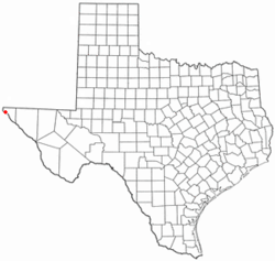 Location in the state of Texas | |
| Coordinates: 31.797°N 106.247°W | |
| Country | United States |
| State | Texas |
| County | El Paso County |
| City | El Paso |
| Elevation | 3,600 ft (1,100 m) |
| Time zone | UTC-6 (MDT) |
| • Summer (DST) | UTC-6 (CDT) |
 | This article about a location in El Paso County, Texas is a stub. You can help Wikipedia by expanding it. |
Текст в блоке "Читать" взят с сайта "Википедия" и доступен по лицензии Creative Commons Attribution-ShareAlike; в отдельных случаях могут действовать дополнительные условия.
Другой контент может иметь иную лицензию. Перед использованием материалов сайта WikiSort.org внимательно изучите правила лицензирования конкретных элементов наполнения сайта.
Другой контент может иметь иную лицензию. Перед использованием материалов сайта WikiSort.org внимательно изучите правила лицензирования конкретных элементов наполнения сайта.
2019-2026
WikiSort.org - проект по пересортировке и дополнению контента Википедии
WikiSort.org - проект по пересортировке и дополнению контента Википедии