world.wikisort.org - USA
Tecumseh is an unincorporated community in Shawnee County, Kansas, United States,[1] and situated along the Kansas River. As of the 2020 census, the population of the community and nearby areas was 696.[2] The community and township are both named for the Shawnee chief.[3][4]
Tecumseh, Kansas | |
|---|---|
Unincorporated community | |
 Main part of Tecumseh. Church and Topeka & Shawnee County Public Library bookmobile stop and book drop-off box to the left. United States Postal Service office to the right. | |
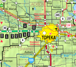 KDOT map of Shawnee County (legend) | |
 Tecumseh  Tecumseh | |
| Coordinates: 39°2′53″N 95°34′45″W[1] | |
| Country | United States |
| State | Kansas |
| County | Shawnee |
| Elevation | 912 ft (278 m) |
| Population (2020)[2] | |
| • Total | 696 |
| Time zone | UTC-6 (CST) |
| • Summer (DST) | UTC-5 (CDT) |
| ZIP code | 66542 |
| Area code | 785 |
| FIPS code | 20-70075 [1] |
| GNIS ID | 478796 [1] |
History
By September 1, 1854, Thomas Stinson platted the townsite of Tecumseh, having settled in the area within the Kansas Territory.[3] It was settled by pro-slavery partisans in the turbulent days of Bleeding Kansas. It temporarily served as the pro-southern capital of the territory and prospered, even having a newspaper. The town's post office opened in March 1855.[5] In 1886, the brick courthouse was sold for US$500 (equivalent to $15,100 in 2021) and removed.[3] After the Civil War, the town rapidly declined and remained so for the next ninety years.
Construction of the Kansas Power & Light Co. power plant in 1924 and 1925.[3] In 1958, Du Pont established a cellophane plant east of town which created a minor boom.[3] As Topeka grew in the 1950s, Tecumseh again started to grow, this time as a suburb of Topeka, with numerous suburban housing subdivisions.
Geography
Tecumseh is located at 39°02′53″N 95°34′45″W (39.0480558, -95.5791453),[6] in Section 36, Township 11 south, Range 16 east. It is situated south of the Kansas River between Tecumseh Creek to the east and Stinson Creek to the west. Contained entirely within Tecumseh Township, it is about 2 miles east of the Topeka city limits.[7] U.S. Route 40 passes the south side of Tecumseh. A BNSF rail line—running between Lawrence and Topeka—passes north of the town between it and the river.
Demographics
| Historical population | |||
|---|---|---|---|
| Census | Pop. | %± | |
| 2020 | 696 | — | |
| U.S. Decennial Census | |||
Tecumseh is part of the Topeka, Kansas Metropolitan Statistical Area.
For statistical purposes, the United States Census Bureau has defined this community as a census-designated place (CDP).
Economy
The community includes a public school (part of USD 450), two churches, a post office, a large electrical generating plant and a cellophane factory.[8]
Education
The community is served by Shawnee Heights USD 450 public school district.
References
- "Tecumseh, Kansas", Geographic Names Information System, United States Geological Survey
- "Profile of Tecumseh, Kansas (CDP) in 2020". United States Census Bureau. Archived from the original on June 8, 2022. Retrieved June 8, 2022.
- Bird, Roy D.; Douglass W. Wallace (1976). Robert W. Richmond & Joseph W. Snell (ed.). Witness of the Times: A History of Shawnee County. Topeka, Kansas: Shawnee County Historical Society. pp. 351–352. ISBN 0-916934-03-9.
- Heim, Michael (2007). Exploring Kansas Highways. p. 49.
- "Kansas Post Offices Database". Kansas State Historical Society. Retrieved 2008-02-09. Containing information taken from Baughman, Robert W. Kansas Post Offices, May 29, 1828–August 3, 1961. Kansas Postal History Society.
- "US Board on Geographic Names". United States Geological Survey. 2007-10-25. Retrieved 2008-01-31.
- "KDOT County Maps". 1994. Retrieved 2008-02-09.
- Japanese firm to invest $30 million in Tecumseh cellophane plant, the last plant of its kind in U.S.; The Topeka Capital Journal; May 18, 2016.
Further reading
External links
Municipalities and communities of Shawnee County, Kansas, United States | ||
|---|---|---|
County seat: Topeka | ||
| Cities | 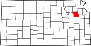 | |
| Unincorporated communities | ||
| Ghost town |
| |
| Townships |
| |
| Footnotes | †This community is designated a Census-Designated Place (CDP) by the United States Census Bureau. ‡This community also has portions in an adjacent county or counties. | |
| ||
Authority control | |
|---|---|
| General |
|
| National libraries | |
| Other | |
Другой контент может иметь иную лицензию. Перед использованием материалов сайта WikiSort.org внимательно изучите правила лицензирования конкретных элементов наполнения сайта.
WikiSort.org - проект по пересортировке и дополнению контента Википедии