world.wikisort.org - USA
Taft is a city in San Patricio County, Texas, United States. The population was 3,048 at the 2010 census.
Taft, Texas | |
|---|---|
City | |
 Sign at the entrance to Taft | |
| Nickname: "The Friendliest Cotton Pickin' Town in Texas" | |
 Location of Taft, Texas | |
 | |
| Coordinates: 27°58′43″N 97°23′40″W | |
| Country | United States |
| State | Texas |
| County | San Patricio |
| Government | |
| Area | |
| • Total | 1.67 sq mi (4.32 km2) |
| • Land | 1.67 sq mi (4.32 km2) |
| • Water | 0.00 sq mi (0.00 km2) |
| Elevation | 49 ft (15 m) |
| Population (2010) | |
| • Total | 3,048 |
| • Estimate (2019)[2] | 2,867 |
| • Density | 1,717.80/sq mi (663.21/km2) |
| Time zone | UTC-6 (Central (CST)) |
| • Summer (DST) | UTC-5 (CDT) |
| ZIP code | 78390 |
| Area code | 361 |
| FIPS code | 48-71684[3] |
| GNIS feature ID | 1348200[4] |
| Website | www |
History
Taft, often called the "Friendliest Cotton-Pickin' Town in Texas", is not only rich in cotton, but also gas and oil resources. Taft was once the center of the million acre Taft Ranch. The ranch was built and owned by Charles Phelps Taft, the half-brother of President William Howard Taft. The nearby city of Sinton, Texas is named for his father-in-law David Sinton. The Blackland Museum houses everything from antique farm equipment to personal and household items used by the town's earliest inhabitants. Every year at Christmas time Santa leads a parade from his perch high atop a city fire truck, delighting residents and visitors of all ages.[citation needed]
On the evening of 25 August 2017, Hurricane Harvey, a Category 4 Hurricane, made landfall near Rockport, Texas approximately thirty miles north of Taft, at 10 PM CST. Taft was brushed by the outer-bands of the eye wall with winds recorded at 90 mph.[citation needed]
Hurricane Harvey was the first Category 4 Hurricane in over twenty years to hit the city.[citation needed]
Education
The City of Taft is served by the Taft Independent School District.
Schools that serve the city include Woodrow Petty Elementary (Pre-K–5), Taft Junior High School (6–8), and Taft High School (9–12).
Geography
Taft is located at 27°58′43″N 97°23′40″W (27.978584, –97.394320).[5]
According to the United States Census Bureau, the city has a total area of 1.5 square miles (3.9 km2), all land.
Climate
The climate in this area is characterized by hot, humid summers and generally mild to cool winters. According to the Köppen Climate Classification system, Taft has a humid subtropical climate, abbreviated "Cfa" on climate maps.[6]
Demographics
| Historical population | |||
|---|---|---|---|
| Census | Pop. | %± | |
| 1930 | 1,792 | — | |
| 1940 | 2,686 | 49.9% | |
| 1950 | 2,978 | 10.9% | |
| 1960 | 3,463 | 16.3% | |
| 1970 | 3,274 | −5.5% | |
| 1980 | 3,686 | 12.6% | |
| 1990 | 3,222 | −12.6% | |
| 2000 | 3,396 | 5.4% | |
| 2010 | 3,048 | −10.2% | |
| 2019 (est.) | 2,867 | [2] | −5.9% |
| U.S. Decennial Census[7] | |||
2020 census
| Race | Number | Percentage |
|---|---|---|
| White (NH) | 550 | 19.64% |
| Black or African American (NH) | 41 | 1.46% |
| Native American or Alaska Native (NH) | 2 | 0.07% |
| Asian (NH) | 1 | 0.04% |
| Some Other Race (NH) | 4 | 0.14% |
| Mixed/Multi-Racial (NH) | 42 | 1.5% |
| Hispanic or Latino | 2,161 | 77.15% |
| Total | 2,801 |
As of the 2020 United States census, there were 2,801 people, 1,033 households, and 824 families residing in the city.
2000 census
As of the census[3] of 2000, there were 3,396 people, 1,084 households, and 835 families residing in the city. The population density was 2,266.1 people per square mile (874.1/km2). There were 1,214 housing units at an average density of 810.1 per square mile (312.5/km2). The racial makeup of the city was 71.02% White, 3.33% African American, 0.21% Native American, 0.06% Asian, 0.03% Pacific Islander, 22.94% from other races, and 2.41% from two or more races. Hispanic or Latino of any race were 67.02% of the population.
There were 1,084 households, out of which 40.9% had children under the age of 18 living with them, 56.7% were married couples living together, 15.0% had a female householder with no husband present, and 22.9% were non-families. 20.3% of all households were made up of individuals, and 10.3% had someone living alone who was 65 years of age or older. The average household size was 3.02 and the average family size was 3.52.
In the city, the population was spread out, with 33.5% under the age of 18, 9.5% from 18 to 24, 25.1% from 25 to 44, 20.1% from 45 to 64, and 11.8% who were 65 years of age or older. The median age was 30 years. For every 100 females, there were 96.1 males. For every 100 females age 18 and over, there were 91.7 males.
The median income for a household in the city was $24,622, and the median income for a family was $32,065. Males had a median income of $28,571 versus $20,219 for females. The per capita income for the city was $11,573. About 20.7% of families and 25.8% of the population were below the poverty line, including 35.6% of those under age 18 and 22.9% of those age 65 or over.
References
- "2019 U.S. Gazetteer Files". United States Census Bureau. Retrieved August 7, 2020.
- "Population and Housing Unit Estimates". United States Census Bureau. May 24, 2020. Retrieved May 27, 2020.
- "U.S. Census website". United States Census Bureau. Retrieved 2008-01-31.
- "US Board on Geographic Names". United States Geological Survey. 2007-10-25. Retrieved 2008-01-31.
- "US Gazetteer files: 2010, 2000, and 1990". United States Census Bureau. 2011-02-12. Retrieved 2011-04-23.
- Climate Summary for Taft, Texas
- "Census of Population and Housing". Census.gov. Retrieved June 4, 2015.
- "Explore Census Data". data.census.gov. Retrieved 2022-05-21.
- https://www.census.gov/ [not specific enough to verify]
- "About the Hispanic Population and its Origin". www.census.gov. Retrieved 18 May 2022.
Municipalities and communities of San Patricio County, Texas, United States | ||
|---|---|---|
County seat: Sinton | ||
| Cities | 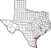 | |
| Towns | ||
| CDPs | ||
| Footnotes | ‡This populated place also has portions in an adjacent county or counties | |
| ||
Authority control | |
|---|---|
| General |
|
| National libraries | |
| Other |
|
Другой контент может иметь иную лицензию. Перед использованием материалов сайта WikiSort.org внимательно изучите правила лицензирования конкретных элементов наполнения сайта.
WikiSort.org - проект по пересортировке и дополнению контента Википедии