world.wikisort.org - USA
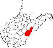
Sunset is a ghost town in Pocahontas County, West Virginia. Sunset was 3.5 miles (5.6 km) northeast of Minnehaha Springs. Sunset appeared on USGS maps as late as 1901.
Sunset, West Virginia | |
|---|---|
Ghost town | |
 Sunset, West Virginia | |
| Coordinates: 38°12′00″N 79°56′39″W | |
| Country | United States |
| State | West Virginia |
| County | Pocahontas |
| Elevation | 2,375 ft (724 m) |
| GNIS feature ID | 1728170[1] |
The community lies west of Sunrise, Virginia, hence the name.[2]
References
- U.S. Geological Survey Geographic Names Information System: Sunset, West Virginia
- Kenny, Hamill (1945). West Virginia Place Names: Their Origin and Meaning, Including the Nomenclature of the Streams and Mountains. Piedmont, WV: The Place Name Press. p. 613.
Текст в блоке "Читать" взят с сайта "Википедия" и доступен по лицензии Creative Commons Attribution-ShareAlike; в отдельных случаях могут действовать дополнительные условия.
Другой контент может иметь иную лицензию. Перед использованием материалов сайта WikiSort.org внимательно изучите правила лицензирования конкретных элементов наполнения сайта.
Другой контент может иметь иную лицензию. Перед использованием материалов сайта WikiSort.org внимательно изучите правила лицензирования конкретных элементов наполнения сайта.
2019-2025
WikiSort.org - проект по пересортировке и дополнению контента Википедии
WikiSort.org - проект по пересортировке и дополнению контента Википедии
