world.wikisort.org - USA
Stovepipe Wells is a way-station in the northern part of Death Valley, in unincorporated Inyo County, California.
Stovepipe Wells | |
|---|---|
Unincorporated community | |
 General store and sign at Stovepipe Wells, December 2017 | |
 Stovepipe Wells Location in California  Stovepipe Wells Location within the United States | |
| Coordinates: 36°36′22″N 117°08′47″W | |
| Country | United States |
| State | California |
| County | Inyo County |
| Elevation | 10 ft (3 m) |
California Historical Landmark | |
| Reference no. | 826 |
Geography and names
Stovepipe Wells is located at 36°36′22″N 117°08′47″W and is US Geological Survey (USGS) feature ID 235564.[1] It is entirely inside Death Valley National Park and along State Route 190 (SR 190) at less than 10 feet (3.0 m) above sea level. West on SR 190 is Towne Pass at about 4,950 feet (1,510 m) above sea level. Eventually, the road meets Panamint Valley Road at Panamint Junction in the Panamint Valley. East on SR 190 the road leads to Furnace Creek and Death Valley Junction.
Variant names listed for the Inyo County location by USGS include Stove Pipe Wells Hotel and Stovepipe Wells Hotel. The US Postal Service ZIP Code is 92328, and the locale name is spelled Stove Pipe Wells in some postal renditions. It is commonly referred to as Stovepipe Wells Village.
Climate
According to the Köppen Climate Classification system, Stovepipe Wells has a hot desert climate, abbreviated "BWh" on climate maps.[2] Its average high temperature is greater than 100 °F from June through September.[2]
| Climate data for Stovepipe Wells, California | |||||||||||||
|---|---|---|---|---|---|---|---|---|---|---|---|---|---|
| Month | Jan | Feb | Mar | Apr | May | Jun | Jul | Aug | Sep | Oct | Nov | Dec | Year |
| Average high °F (°C) | 63.9 (17.7) |
69.1 (20.6) |
78.5 (25.8) |
87.8 (31.0) |
97.9 (36.6) |
107.9 (42.2) |
114.1 (45.6) |
112.0 (44.4) |
102.8 (39.3) |
88.9 (31.6) |
72.5 (22.5) |
60.9 (16.1) |
88.0 (31.1) |
| Daily mean °F (°C) | 52.9 (11.6) |
58.6 (14.8) |
67.8 (19.9) |
76.0 (24.4) |
86.0 (30.0) |
95.1 (35.1) |
101.6 (38.7) |
99.4 (37.4) |
90.6 (32.6) |
77.0 (25.0) |
61.9 (16.6) |
50.7 (10.4) |
76.5 (24.7) |
| Average low °F (°C) | 41.9 (5.5) |
48.0 (8.9) |
57.0 (13.9) |
64.1 (17.8) |
74.1 (23.4) |
82.3 (27.9) |
89.0 (31.7) |
86.7 (30.4) |
78.4 (25.8) |
65.0 (18.3) |
51.3 (10.7) |
40.5 (4.7) |
64.9 (18.3) |
| Average precipitation inches (mm) | 0.4 (10) |
0.7 (18) |
0.7 (18) |
0.3 (7.6) |
0.2 (5.1) |
0.1 (2.5) |
0.2 (5.1) |
0.3 (7.6) |
0.2 (5.1) |
0.1 (2.5) |
0.4 (10) |
0.4 (10) |
4 (101.5) |
| Source: [3] | |||||||||||||
History
The first temporary settlement at Stovepipe Wells came into being when a road between Rhyolite and Skidoo was begun in 1906 to ameliorate the approach to the mine at Skidoo. A collection of tents was erected to serve travelers with food, drink and lodging. During the bonanza days of Rhyolite and Skidoo, it was the only known water source on the Cross-Valley road. When sand obscured the spot, a length of stovepipe was inserted as a marker; hence, its unique name.
In 1925, entrepreneur Bob Eichmann began construction of the hotel at Stovepipe Wells, along with a scenic toll road through Death Valley. This marked the beginning of the transition from mining community to tourist destination.
The settlement is now registered as California Historical Landmark #826.[4]
Facilities
Stovepipe Wells Village is home to the Stovepipe Wells Hotel,[5] a full-service hotel with swimming pool. A general store offers sundries and food and is adjacent to a gas station. Stovepipe Wells Village also houses the Badwater Saloon and Toll Road restaurant, The Nugget Gift Shop and a ranger station.
The default format for wired telephone numbers in the community is in the Death Valley exchange: (760) 786-xxxx. The community had manual telephone service until the late 1980s.
The community is contained within the Great Basin Unified Air Pollution Control District.
Nearby features


- Close to town are some fairly large and accessible stationary sand dunes on the floor of Death Valley. The dunes are roughly 7 miles (11 km) long in the east–west axis. They are located in the space between Salt Creek and Emigrant Wash.
- Stovepipe Well, for which the community is named, is shown to the northeast at 36°39′33″N 117°04′44″W.
- Stovepipe Wells Airport is to the southwest at 36°36′14″N 117°09′33″W. The airport has an identifier of L09 and features a 3,250-foot (990 m) paved runway.
- Stovepipe Wells Campground [6]
- Stovepipe Wells Ranger Station
- Mesquite Flat Sand Dunes
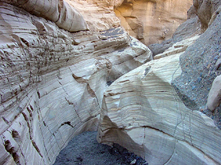
- Mosaic Canyon
- Tucki Mountain
- Grotto Canyon
- Devil's Corn Field
California Historical Landmarks
There are three California Historical Landmarks in Stovepipe Wells.[7]
California Historical Landmark number 826, Old Stovepipe Wells, founded on August 7, 1968 reads:
- NO. 826 OLD STOVEPIPE WELLS - This waterhole, the only one in the sand dune area of Death Valley, was at the junction of the two Indian trails. During the bonanza days of Rhyolite and Skidoo, it was the only known water source on the cross-valley road. When sand obscured the spot, a length of stovepipe was inserted as a marker.[8]
California Historical Landmark number 848, Eichbaum Toll Road, founded on May 19, 1971 reads:
- NO. 848 EICHBAUM TOLL ROAD - In 1926, H. W. Eichbaum obtained a franchise for a toll road from Darwin Falls to Stovepipe Wells, the first maintained road into Death Valley from the west. It changed the area's economic base from mining to tourism and brought about the creation of Death Valley National Monument seven years later[9]
California Historical Landmark number 441, Burned Wagons Point, founded on October 24, 1949 reads:
- NO. 441 BURNED WAGONS POINT - Near this monument, the Jayhawker group of Death Valley '49ers, gold seekers from the Middle West who entered Death Valley in 1849 seeking a short route to the mines of central California, burned their wagons, dried the meat of some oxen and, with surviving animals, struggled westward on foot.[10]
Gallery
 Stovepipe Wells "downtown"
 Stovepipe Wells Fire Dept truck
 Burned Wagons plaque, California Historical Landmark
 Stovepipe Wells saloon at dusk
 Stovepipe Wells general store at dusk
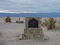 California Historical Landmark Old Stovepipe Wells
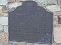 California Historical Landmark Eichbaum Toll Road Plaque
 Sea Level sign in Stovepipe Wells
 Stovepipe Wells Dunes at Sunrise


See also
- California Historical Landmarks in Inyo County
- History of California through 1899
Sources
- U.S. Geological Survey Geographic Names Information System: Stovepipe Wells, California
- Climate Summary for Stovepipe Wells, California
- "Monthly Averages for Stovepipe Wells, CA". weatherbase.com. Retrieved 2017-12-24.
- "Stovepipe Wells". Office of Historic Preservation, California State Parks. Retrieved 2012-10-07.
- Stovepipe Wells Hotel
- nps.gov Stovepipe Wells Campground
- California Parks, California Historical Landmark
- californiahistoricallandmarks.com Landmarks chl-826
- californiahistoricallandmarks.com Landmarks chl-848
- californiahistoricallandmarks.com Landmarks chl-441
- 7350.7U Location Identifiers, The National Flight Data Center, Federal Aviation Administration ATPUBS, US Department of Transportation, September 1, 2005.
- Map: Stovepipe Wells, California 7.5-minute quadrangle, US Geological Survey, 1988.
- National Geographic Names Database, US Geological Survey, 1995.
- California Air Resources Board web site.
- Richard E. Lingenfelter. (1988) Death Valley and the Amargosa: A Land of Illusion: University of California Press. p. 290, p. 475.
External links
Municipalities and communities of Inyo County, California, United States | ||
|---|---|---|
County seat: Independence | ||
| City |  | |
| CDPs | ||
| Unincorporated communities | ||
| Indian reservations |
| |
| Ghost towns |
| |
| Other |
| |
| ||
Другой контент может иметь иную лицензию. Перед использованием материалов сайта WikiSort.org внимательно изучите правила лицензирования конкретных элементов наполнения сайта.
WikiSort.org - проект по пересортировке и дополнению контента Википедии