world.wikisort.org - USA
Southampton is a village in the Town of Southampton in Suffolk County, on the South Fork of Long Island, in New York, United States. The population was 3,109 at the 2010 census.[2][3]
Southampton, New York | |
|---|---|
Village Town Seat of Southampton | |
| Incorporated Village of Southampton | |
 Downtown Southampton in 2014. | |
 Southampton, New York Location on Long Island  Southampton, New York Location within the state of New York  Southampton, New York Location within the contiguous United States | |
| Coordinates: 40°53′7″N 72°23′43″W | |
| Country | |
| State | |
| County | Suffolk |
| Town | Southampton |
| First Settled | 1640 |
| Incorporation | 1894 |
| Named for | Earl of Southampton |
| Government | |
| • Mayor | Jesse Warren |
| • Deputy Mayor | Gina Arresta |
| Area | |
| • Total | 7.43 sq mi (19.24 km2) |
| • Land | 6.52 sq mi (16.88 km2) |
| • Water | 0.91 sq mi (2.36 km2) |
| Elevation | 26 ft (8 m) |
| Population (2020) | |
| • Total | 4,550 |
| • Density | 698.07/sq mi (269.52/km2) |
| Time zone | UTC-5 (Eastern (EST)) |
| • Summer (DST) | UTC-4 (EDT) |
| ZIP Codes | 11968-11969 |
| Area code(s) | 631, 934 |
| FIPS code | 36-68462 |
| GNIS feature ID | 0965893 |
| Website | www |
The Incorporated Village of Southampton serves as the Town Seat of the Town of Southampton, and is the oldest and largest of communities in the summer colony known as The Hamptons.
History
![First Presbyterian Church, Main Street, Southampton, New York[4]](http://upload.wikimedia.org/wikipedia/commons/5/54/Southampton_NY_1st_Presby_PHS0830.jpg)
Southampton, settled in 1640 and incorporated as a village in 1894, historically began with a small group of English settlers who set sail from Lynn, Massachusetts, and landed on June 12, 1640, at what is now known as Conscience Point. It is the oldest English settlement in the state of New York and is named after the English Earl of Southampton.
The Shinnecock tribe welcomed the arrival of the white settlers in 1640 and not only gave them land to live on, "Olde Towne", but also shared with the settlers their knowledge of planting corn and fertilizing it with fish, growing crops, digging clams and scallops from nearby bays and trapping game. During the 18th and 19th centuries, fishing, farming (especially potatoes and the local sweet corn) and duck raising were the predominant industries.
The early settlers, with the help of a resident Shinnecock Indian guide, were led over an old woodland trail that is now North Sea Road to an ideal spot for their first settlement. There, at the head of what today is Old Town Pond, they constructed their first homes. The Shinnecock Reservation, established in 1701, is one of the oldest Native American reservations in the United States.
A property called the Halsey House was a homestead by pioneer Thomas Halsey in 1640. A rare "first period" house was built in 1660 when Main Street, in the pioneer hamlet of Southampton, was first laid out. Its owner, Thomas Halsey, was one of the original families who bought property from the Shinnecocks in 1640.[5] It is one of the oldest English-type frame houses in the state.
Summer Colony
Dr. Theodore Gaillard Thomas, a New York City physician is regarded at the founder of the resort community, also termed the Summer Colony, of Southampton. He convinced a number of his wealthy clients about the beauty and potential restorative nature of the rural environment of Southampton. His efforts to develop this resort community began in 1863. He proved very successful at establishing what grew into a very prominent and affluent community of summer residents. Dr. Thomas and his friends ultimately established many of the leading institutions in Southampton including the St. Andrews Dune Church, the Shinnecock Golf Club, the Meadow Club, the Southampton Beach Club and The Parrish Art Museum (now located in Water Mill, NY).[6]
Over time, several of the other villages and hamlets in what has become called the Hamptons increasingly became a haven for affluent summer season vacationers. Southampton Village, which hosted the earliest summer community of socially prominent residents and was arguably the center for upper class Americans, grew larger and faster than the others. Southampton has served as home to members of the Ford, Du Pont, Morgan, Atterbury, Woolworth and Eisenhower families.[7]
21st century
Southampton Village is regarded as one of the premier summer resort areas in the country.[8] The community of summer residents occupy the top echelon of American social, political and financial circles.
Accordingly, real estate is extremely expensive in the village. The Estate Section, which contains the majority of the homes for the very affluent residents, lies directly north of the Atlantic oceanfront and extends to Hill Street. Particular streets of note in the area include Ox Pasture Road, Halsey Neck Lane, Coopers Neck Lane, First Neck Lane and South Main Street. The homes around Lake Agawam, referred to by Dr. Thomas as "the very center of our Summer Colony" are particularly noteworthy for their architectural pedigree and historical provenance.
The oceanfront roads—Gin Lane and Meadow Lane—are generally the most expensive roads in the village. Meadow Lane in particular has been called Billionaire Lane, and cited as having among the most expensive residential real estate in the country.[9]
Other areas in the village house the relatively large population of year-round residents. These neighborhoods extend from Hill Street northwards to Route 27, east to the hamlet of Water Mill, and west to the area of Tuckahoe in Southampton Town.
The Shinnecock Indian Reservation borders the village on its southwestern border. Shinnecock Hills Golf Club one of the oldest and most prestigious golf courses in the country, borders the village on its northwest corner. The Art Village, a summer art school started by William Merritt Chase and funded by early residents of the Southampton Summer Colony, is still in existence, though now it is entirely private residences; no arts education is conducted in the Art Village any more.
There are several working farms and agricultural preserves in the village.[10] Most of those properties are located in the Estate Section, particularly in the Wickapogue Road Historic District.
Southampton Village boasts well regarded ocean beaches including Cooper's Beach, which was voted #3 in a recent national poll. In 2010 it was listed as America's top beach according to the annual list of the best American beaches compiled by Dr. Stephen Leatherman, AKA Dr. Beach.[11]
Geography

According to the United States Census Bureau, the village has a total area of 7.2 square miles (18.7 km2), of which 6.4 square miles (16.6 km2) is land and 0.81 square miles (2.1 km2), or 11.03%, is water.[3][12]
The village gained territory between the 1990 census and the 2000 census; the Southampton CDP that existed in 1990 was deleted and most of its territory went to two adjacent CDPs.[13]
Demographics
| Historical population | |||
|---|---|---|---|
| Census | Pop. | %± | |
| 1870 | 943 | — | |
| 1880 | 949 | 0.6% | |
| 1900 | 2,289 | — | |
| 1910 | 2,509 | 9.6% | |
| 1920 | 2,891 | 15.2% | |
| 1930 | 3,737 | 29.3% | |
| 1940 | 3,818 | 2.2% | |
| 1950 | 4,042 | 5.9% | |
| 1960 | 4,582 | 13.4% | |
| 1970 | 4,904 | 7.0% | |
| 1980 | 4,000 | −18.4% | |
| 1990 | 3,980 | −0.5% | |
| 2000 | 3,965 | −0.4% | |
| 2010 | 3,109 | −21.6% | |
| 2020 | 4,550 | 46.3% | |
| U.S. Decennial Census[14] | |||
2017 American Community Survey
According to US Census estimates as of March 2017, there were 3,193 people in the village.[15] The population density was 498.9 people per square mile (192.6/km2). The racial makeup of the village was 74.5% White, 16.7% Black or African American, 0.4% Native American, 3.60% Asian, 0.03% Pacific Islander, 4.40% from other races, and 0.90% from two or more races. Hispanic or Latino of any race were 22.5% of the population.
In the village, the population was spread out, with 16.2% under the age of 19, 1.7% from 18 to 24, 12.4% from 19 to 34, 39.8% from 35 to 64, and 29.9% who were 65 years of age or older. The median age was 55.2 years. The Village's residents were estimated to be 46% male and 54% female.
Also, as per the 2015 Census Data estimates, the median income for a household in the village was $96,250 and the median income for a family was $109,674. Twenty two percent of the households in the Village earned over $200,000.
As per the 2000 Census, there were 1,651 households, out of which 21.9% had children under the age of 18 living with them, 42.1% were married couples living together, 12.1% had a female householder with no husband present, and 40.5% were non-families. 34.2% of all households were made up of individuals, and 15.4% had someone living alone who was 65 years of age or older. The average household size was 2.36 and the average family size was 2.97.
Census 2000
As of the census of 2000, there were 3,965 people, 1,651 households, and 982 families residing in the village.[15] The population density was 626.7 people per square mile (241.8/km²). There were 2,936 housing units at an average density of 464.0 per square mile (179.1/km²). The racial makeup of the village was 80.38% White, 12.94% Black or African American, 0.83% Native American, 1.59% Asian, 0.03% Pacific Islander, 1.97% from other races, and 2.27% from two or more races. Hispanic or Latino of any race were 9.05% of the population.
There were 1,651 households out of which 21.9% had children under the age of 18 living with them, 42.1% were married couples living together, 12.1% had a female householder with no husband present, and 40.5% were non-families. 34.2% of all households were made up of individuals and 15.4% had someone living alone who was 65 years of age or older. The average household size was 2.36 and the average family size was 2.97.
In the village the population was spread out with 19.5% under the age of 18, 7.3% from 18 to 24, 24.8% from 25 to 44, 27.2% from 45 to 64, and 21.1% who were 65 years of age or older. The median age was 44 years. For every 100 females there were 93.6 males. For every 100 females age 18 and over, there were 91.6 males.
The median income for a household in the village was $54,030, and the median income for a family was $61,016. Males had a median income of $40,729 versus $36,875 for females. The per capita income for the village was $37,015. About 1.3% of families and 6.2% of the population were below the poverty line, including 2.6% of those under age 18 and 3.9% of those age 65 or over.
Government
As of September 2022, the Mayor Southampton is Jesse Warren, the Deputy Mayor is Gina Arresta, and the Village Trustees are Robin Brown, William "Bill" Manger Jr., and Roy Stevenson.[16]
At the time of Warren's election, the 37-year-old became the village's youngest mayor.[17]
Village police
This area is policed by the Southampton Village Police Department.[18][19]
Historic districts
- Beach Road Historic District
- North Main Street Historic District
- Southampton Village Historic District
- Wickapogue Road Historic District
Notable residents
Many wealthy and influential people have homes in the "estate section" of the village, the area immediately north of the Atlantic Ocean front. Southampton has historically been home to prominent residents including members of the Ford, Du Pont, Eisenhower, Vanderbilt and Morgan families.[20] Today, the village is itself home to approximately half of the billionaires who have residences in the eight hamlets and villages that constitute the Hamptons.[21]
Other notable residents include:
- Tim Bishop, former U.S. Representative for New York's 1st congressional district
- Elizabeth Bogart, 19th-century poet
- Aby Rosen, real estate mogul
- Ian Schrager, hotelier
- Tory Burch, fashion designer, business woman, and philanthropist
- Brooke Shields, actress
- Amanda Clark, Olympic sailor
- Pyrrhus Concer, First African American whaler to reach restricted Japan and Southampton Village ferryboat operator
- Ansel Elgort, actor
- Michael J. Fox, actor
- Paul Gibson, Major League Baseball pitcher
- Grenville Goodwin, anthropologist
- Jehiel H. Halsey, lawyer and politician
- Nicoll Halsey, U.S. Representative
- Silas Halsey, U.S. Representative
- Andre Johnson, NFL football player
- Calvin Klein, fashion designer
- David H. Koch, businessman
- Henry Kravis, financier
- Edward Mellon architect[22]
- Steven Mnuchin, financier and US Treasury Secretary
- J. P. Morgan, financier
- Roy Lichtenstein, painter
- Adebayo Ogunlesi, financier and founder of Global Infrastructure Partners
- John Paulson
- Lee Radziwill
- Felix Rohatyn, financier who saved New York City from bankruptcy in the 1970s
- Wilbur Ross, billionaire investor and US Commerce Secretary
- William Salomon
- Arthur Ochs "Punch" Sulzberger Sr., former publisher of The New York Times
- Chuck Scarborough, longstanding news anchor
- Jean Shafiroff, philanthropist and socialite
- George Soros, business magnate, investor, and philanthropist
- Kate Spade
- Howard Stein, financier
- Howard Stern radio personality
- Carlos Eduardo Stolk, diplomat, business magnate
- A. Alfred Taubman, real estate developer and philanthropist
- Foots Walker, NBA basketball player
- Tom Wolfe, author and journalist
Image gallery
 First Presbyterian Church – Oldest Presbyterian church in America was established in 1640 by Puritans from Lynn, Mass. Clock tower on wood gothic church built in 1843 and enlarged in 1895.
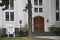 First Presbyterian Church – Southampton Village on Main St.
 Southampton Village on South Main St. 2 main st Plaque.
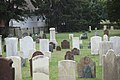 North End Graveyard, it contains the graves of many veterans of the revolutionary war.
 The Old Halsey House in the spring of 2011.
![Mercator Cooper house in Southampton. The house is now used by the town library.[23]](//upload.wikimedia.org/wikipedia/commons/thumb/f/f5/Mercator-cooper-house.jpg/120px-Mercator-cooper-house.jpg) Mercator Cooper house in Southampton. The house is now used by the town library.[23]
Mercator Cooper house in Southampton. The house is now used by the town library.[23]


![Mercator Cooper house in Southampton. The house is now used by the town library.[23]](http://upload.wikimedia.org/wikipedia/commons/f/f5/Mercator-cooper-house.jpg)
References
- "ArcGIS REST Services Directory". United States Census Bureau. Retrieved September 20, 2022.
- "Suffolk County Tax Map Range". Town of Southampton. Archived from the original on January 8, 2012. Retrieved September 25, 2013.
Village of North Haven, Village of Quogue, Village of Southampton, Village of W. Hampton Beach, Village of Sag Harbor, Village of W. Hampton Dunes, Village of Sagaponack, Southampton Town
- "Geographic Identifiers: 2010 Demographic Profile Data (G001): Southampton village, New York". U.S. Census Bureau, American Factfinder. Archived from the original on February 12, 2020. Retrieved December 21, 2012.
- Presbyterian Historical Society, Wikimedia Commons
- "Indian Deed of December 13, 1640". southamptontownny.gov.
- "Blue Blood: The Story of the Founding of the Southampton Summer Colony"
- " Southampton Village: The Transition to Stylish Resort"
- "Southampton Celebrates 375 Years'
- "The Hamptons' Billionaire Lane, Mapped"
- "The Most Valuable Corn in the World"
- Yahoo Travel
- "US Gazetteer files: 2010, 2000, and 1990". United States Census Bureau. February 12, 2011. Retrieved April 23, 2011.
- "New York: 2000 Population and Housing Unit Counts" (PDF). September 2003. p. III-16. Retrieved December 22, 2010.
- "Census of Population and Housing". Census.gov. Retrieved June 4, 2015.
- "U.S. Census website". Retrieved March 5, 2017.
- "Southampton Village, NY | Official Website". www.southamptonvillage.org. Retrieved September 8, 2022.
- Morris, Bob (August 19, 2019). "How Old Are You, Mr. Mayor?". The New Yorker. Retrieved April 8, 2020.
- "Long Island Index: Interactive Map". www.longislandindexmaps.org. Retrieved September 8, 2022.
- "Southampton Village Police". www.svpd.com. Retrieved September 8, 2022.
- "Southampton, New York: a village of refined, seaside luxury"
- "Beach Magazine article The Boys Club, pg. 90 - 98"
- Sally Spanburgh (May 25, 2015). The Southampton Cottages of South Main Street: The Original Hamptons Summer Colony. Arcadia Publishing. p. 74. ISBN 978-1-62619-291-1. Retrieved August 26, 2015.
- Marquardt, Jim (November 15, 2012). "Into Tokyo Harbor". Sag Harbor Express. p. 7 – via NYS Historic Newspapers.
External links
- Village of Southampton official website
- Village of Southampton Police Department official website
- The Southampton Press
- Hamptons.com
- Lake Agawam Conservation Association
Другой контент может иметь иную лицензию. Перед использованием материалов сайта WikiSort.org внимательно изучите правила лицензирования конкретных элементов наполнения сайта.
WikiSort.org - проект по пересортировке и дополнению контента Википедии