world.wikisort.org - USA
Singac (pronounced SING-ack[citation needed]) is an unincorporated community and census-designated place (CDP) located within Little Falls Township, in Passaic County, New Jersey, United States.[10][11][12][13] As of the 2010 United States Census, the CDP's population was 3,618.[14]
Singac, New Jersey | |
|---|---|
Census-designated place | |
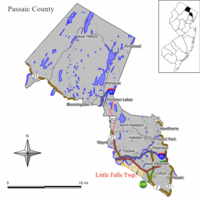 Map of Little Falls in Passaic County; Singac is located in the western end of Little Falls. Inset: Location of Passaic County highlighted in the State of New Jersey. | |
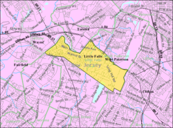 Census Bureau map of Little Falls, New Jersey, in which Singac is located at its western end | |
| Coordinates: 40.884254°N 74.243539°W[1][2] | |
| Country | |
| State | |
| County | Passaic |
| Township | Little Falls |
| Area | |
| • Total | 0.49 sq mi (1.27 km2) |
| • Land | 0.46 sq mi (1.19 km2) |
| • Water | 0.03 sq mi (0.08 km2) 6.34% |
| Elevation | 167 ft (51 m) |
| Population (2020)[5] | |
| • Total | 3,602 |
| • Density | 7,847.49/sq mi (3,027.39/km2) |
| Time zone | UTC-5 (Eastern (EST)) |
| • Summer (DST) | UTC-4 (Eastern (EDT)) |
| ZIP code | 07424[6] |
| Area code(s) | 862/973 |
| FIPS code | 3467770[1][7] |
| GNIS feature ID | 02584027[1][8][9] |
Geography
According to the United States Census Bureau, the CDP had a total area of 0.498 square miles (1.289 km2), including 0.466 square miles (1.207 km2) of land and 0.032 square miles (0.082 km2) of water (6.34%).[1][2]
Singac is a neighborhood in the western end of Little Falls Township. It is bounded to the north by the Passaic River. New Jersey Route 23, known as the Newark-Pompton Turnpike or Pompton Avenue, runs north-south through the community.
Demographics
| Historical population | |||
|---|---|---|---|
| Census | Pop. | %± | |
| 2020 | 3,602 | — | |
| U.S. Decennial Census[15][5] | |||
The 2010 United States census counted 3,618 people, 1,477 households, and 920 families in the CDP. The population density was 7,763.6 per square mile (2,997.5/km2). There were 1,545 housing units at an average density of 3,315.3 per square mile (1,280.0/km2). The racial makeup was 88.00% (3,184) White, 1.35% (49) Black or African American, 0.14% (5) Native American, 5.80% (210) Asian, 0.00% (0) Pacific Islander, 2.65% (96) from other races, and 2.05% (74) from two or more races. Hispanic or Latino of any race were 12.82% (464) of the population.[14]
Of the 1,477 households, 25.5% had children under the age of 18; 45.6% were married couples living together; 11.7% had a female householder with no husband present and 37.7% were non-families. Of all households, 31.5% were made up of individuals and 9.9% had someone living alone who was 65 years of age or older. The average household size was 2.45 and the average family size was 3.16.[14]
19.5% of the population were under the age of 18, 7.7% from 18 to 24, 30.6% from 25 to 44, 27.7% from 45 to 64, and 14.5% who were 65 years of age or older. The median age was 40.1 years. For every 100 females, the population had 94.5 males. For every 100 females ages 18 and older there were 90.5 males.[14]
References
- Gazetteer of New Jersey Places, United States Census Bureau. Accessed July 21, 2016.
- US Gazetteer files: 2010, 2000, and 1990, United States Census Bureau. Accessed September 4, 2014.
- "ArcGIS REST Services Directory". United States Census Bureau. Retrieved October 11, 2022.
- U.S. Geological Survey Geographic Names Information System: Singac Census Designated Place, Geographic Names Information System. Accessed January 16, 2013.
- "Census Population API". United States Census Bureau. Retrieved Oct 11, 2022.
- Look Up a ZIP Code for Singac, NJ, United States Postal Service. Accessed January 16, 2013.
- U.S. Census website, United States Census Bureau. Accessed September 4, 2014.
- US Board on Geographic Names, United States Geological Survey. Accessed September 4, 2014.
- A Cure for the Common Codes: New Jersey, Missouri Census Data Center. Accessed January 16, 2013.
- GCT-PH1 - Population, Housing Units, Area, and Density: 2010 - County -- County Subdivision and Place from the 2010 Census Summary File 1 for Passaic County, New Jersey Archived 2020-02-12 at archive.today, United States Census Bureau. Accessed January 12, 2013.
- 2006-2010 American Community Survey Geography for New Jersey, United States Census Bureau. Accessed January 12, 2013.
- New Jersey: 2010 - Population and Housing Unit Counts - 2010 Census of Population and Housing (CPH-2-32), United States Census Bureau, August 2012. Accessed January 12, 2013.
- Locality Search, State of New Jersey. Accessed April 19, 2015.
- DP-1 - Profile of General Population and Housing Characteristics: 2010 Demographic Profile Data for Singac CDP, New Jersey, United States Census Bureau. Accessed January 16, 2013.
- "Census of Population and Housing". Census.gov. Retrieved June 4, 2016.
Municipalities and communities of Passaic County, New Jersey, United States | ||
|---|---|---|
County seat: Paterson | ||
| Cities |  | |
| Boroughs | ||
| Townships | ||
| CDPs |
| |
| Other communities | ||
| Footnotes | ‡This populated place also has portions in an adjacent county or counties | |
| ||
Другой контент может иметь иную лицензию. Перед использованием материалов сайта WikiSort.org внимательно изучите правила лицензирования конкретных элементов наполнения сайта.
WikiSort.org - проект по пересортировке и дополнению контента Википедии