world.wikisort.org - USA
Sims is an unincorporated community and census-designated place (CDP) in Sims Township, Grant County, Indiana. In 2010 it had a population of 156.[4]
Sims, Indiana | |
|---|---|
Census-designated place | |
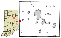 Location of Sims in Grant County, Indiana. | |
 Sims  Sims | |
| Coordinates: 40°29′59″N 85°51′19″W | |
| Country | United States |
| State | Indiana |
| County | Grant |
| Township | Sims |
| Area | |
| • Total | 1.00 sq mi (2.58 km2) |
| • Land | 1.00 sq mi (2.58 km2) |
| • Water | 0.00 sq mi (0.00 km2) |
| Elevation | 860 ft (260 m) |
| Population (2020) | |
| • Total | 164 |
| • Density | 164.33/sq mi (63.46/km2) |
| ZIP code | 46986 |
| FIPS code | 18-69894[3] |
| GNIS feature ID | 443539 |
History
The community took its name from Sims Township.[5] A post office was established at Sims in 1881, and remained in operation until it was discontinued in 1992.[6]
Geography
Sims is located at 40°29′59″N 85°51′19″W near the western border of Grant County. It is 2 miles (3 km) west of Swayzee and 13 miles (21 km) southwest of Marion, the county seat. A rail line operated by the Central Railroad Company of Indianapolis passes along the north side of town.
According to the U.S. Census Bureau, the Sims CDP has a total area of 1.0 square mile (2.6 km2), all of it land.[4]
Demographics
| Historical population | |||
|---|---|---|---|
| Census | Pop. | %± | |
| 2020 | 164 | — | |
| U.S. Decennial Census[7] | |||
References
- "2020 U.S. Gazetteer Files". United States Census Bureau. Retrieved March 16, 2022.
- "US Board on Geographic Names". United States Geological Survey. 2007-10-25. Retrieved 2008-01-31.
- "U.S. Census website". United States Census Bureau. Retrieved 2008-01-31.
- "Geographic Identifiers: 2010 Demographic Profile Data (G001): Sims CDP, Indiana". American Factfinder. U.S. Census Bureau. Retrieved December 5, 2016.[dead link]
- Baker, Ronald L. (October 1995). From Needmore to Prosperity: Hoosier Place Names in Folklore and History. Indiana University Press. p. 302. ISBN 978-0-253-32866-3.
...named for Sims Township, in which it is located...
- "Grant County". Jim Forte Postal History. Retrieved 12 September 2014.
- "Census of Population and Housing". Census.gov. Retrieved June 4, 2016.
Municipalities and communities of Grant County, Indiana, United States | ||
|---|---|---|
County seat: Marion | ||
| Cities |
|  |
| Towns |
| |
| Townships |
| |
| CDPs | ||
| Unincorporated communities |
| |
| Footnotes | ‡This populated place also has portions in an adjacent county or counties | |
| ||
| Authority control |
|
|---|
This Grant County, Indiana location article is a stub. You can help Wikipedia by expanding it. |
Другой контент может иметь иную лицензию. Перед использованием материалов сайта WikiSort.org внимательно изучите правила лицензирования конкретных элементов наполнения сайта.
WikiSort.org - проект по пересортировке и дополнению контента Википедии