 1890 Ranch house.
 Inside the Ranch house.
 Basement of the Ranch house
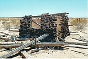
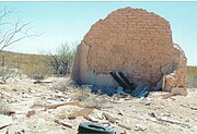 Ruins of the 1895 Sentinel Train Depot
world.wikisort.org - USA
Sentinel is an unincorporated community in Maricopa County, Arizona, United States.[2] It has an estimated elevation of 692 feet (211 m) above sea level.[1]
Sentinel, Arizona | |
|---|---|
Unincorporated community | |
 Ruins of the 1895 Sentinel Train Depot | |
 Sentinel Location within the state of Arizona  Sentinel Sentinel (the United States) | |
| Coordinates: 32°51′29″N 113°12′38″W | |
| Country | United States |
| State | Arizona |
| County | Maricopa |
| Elevation | 692 ft (211 m) |
| Time zone | UTC-7 (Mountain (MST)) |
| • Summer (DST) | UTC-7 (MST) |
| Area code | 928 |
| FIPS code | 04-65630 |
| GNIS feature ID | 11083 |
The train station served the US Army training camps: Camp Horn and Camp Hyder during World War II.[3]
Sentinel ruins
Some of the late 19th Century ruins in Sentinel.
Ruins in Sentinel, Arizona


See also
![]() Arizona portal
Arizona portal
References
External links
![]() Media related to Sentinel, Arizona at Wikimedia Commons
Media related to Sentinel, Arizona at Wikimedia Commons
Municipalities and communities of Maricopa County, Arizona, United States | ||
|---|---|---|
County seat: Phoenix | ||
| Cities |
|  |
| Towns | ||
| CDPs |
| |
| Populated places |
| |
| Indian reservations |
| |
| Ghost towns/ former populated places |
| |
| Footnotes | ‡This populated place also has portions in an adjacent county or counties | |
| ||
Текст в блоке "Читать" взят с сайта "Википедия" и доступен по лицензии Creative Commons Attribution-ShareAlike; в отдельных случаях могут действовать дополнительные условия.
Другой контент может иметь иную лицензию. Перед использованием материалов сайта WikiSort.org внимательно изучите правила лицензирования конкретных элементов наполнения сайта.
Другой контент может иметь иную лицензию. Перед использованием материалов сайта WikiSort.org внимательно изучите правила лицензирования конкретных элементов наполнения сайта.
2019-2026
WikiSort.org - проект по пересортировке и дополнению контента Википедии
WikiSort.org - проект по пересортировке и дополнению контента Википедии