world.wikisort.org - USA
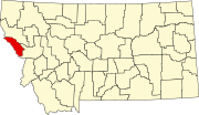
Saltese (also Packers Meadow or Silver City) is an unincorporated community in Mineral County, Montana, United States. Saltese lies an altitude of 3,366 feet (1,026 m).[2] It lies along Interstate 90 with access via exit 10. The St. Regis River flows to the north.
Saltese, Montana
Packers Meadow Silver City | |
|---|---|
Unincorporated Community | |
 Black bear weighing 252 lbs. shot by Jim O'Brine at Saltese, Montana, May 12, 1910 | |
 | |
| Coordinates: 47°24′37″N 115°30′35″W | |
| Country | United States |
| State | Montana |
| County | Mineral |
| Named for | Chief Saltese |
| Area | |
| • Total | 0.33 sq mi (0.85 km2) |
| • Land | 0.33 sq mi (0.85 km2) |
| • Water | 0.00 sq mi (0.00 km2) |
| Elevation | 3,366 ft (1,026 m) |
| Population (2020) | |
| • Total | 10 |
| • Density | 30.40/sq mi (11.75/km2) |
| Time zone | UTC-7 (MST) |
| • Summer (DST) | UTC-6 (MDT) |
| Zip Code | 59867 |
| Area Code | 406 |
| FIPS code | 30-65875 |
"Saltese is an old gold and silver mining town that took its name from a Nez Perce leader, Chief Saltese."[3] "The town was first known as Silver City but was renamed in 1891."[4] The post office opened in 1892.[5]
In December 1912, David D. Bogart, the sixth mayor of Missoula, Montana, was killed in an avalanche in Saltese while prospecting for gold.[6]
In 1996, a longtime establishment, the Old Montana Bar and Grille, was destroyed in a fire.[7]
Demographics
| Historical population | |||
|---|---|---|---|
| Census | Pop. | %± | |
| 2020 | 10 | — | |
| U.S. Decennial Census[8] | |||
References
- "ArcGIS REST Services Directory". United States Census Bureau. Retrieved September 5, 2022.
- U.S. Geological Survey Geographic Names Information System: Saltese, Montana
- "Saltese Montana Travel Information". TravelMT.com. Retrieved 2013-11-18.
- "Saltese". Montana, Official State Travel Site. Retrieved 2013-11-18.
- "Saltese". Montana Place Names Companion. Montana Historical Society. Retrieved 9 April 2021.
- "Missoula Mayors Interred at the Missoula Cemetery". City of Missoula. Retrieved 2012-02-06.
- Rauve, Bekka (January 20, 1996). "Historic bar reduced to ashes, memories". Spokesman-Review. (Spokane, Washington). p. B1.
- "Census of Population and Housing". Census.gov. Retrieved June 4, 2016.
Текст в блоке "Читать" взят с сайта "Википедия" и доступен по лицензии Creative Commons Attribution-ShareAlike; в отдельных случаях могут действовать дополнительные условия.
Другой контент может иметь иную лицензию. Перед использованием материалов сайта WikiSort.org внимательно изучите правила лицензирования конкретных элементов наполнения сайта.
Другой контент может иметь иную лицензию. Перед использованием материалов сайта WikiSort.org внимательно изучите правила лицензирования конкретных элементов наполнения сайта.
2019-2025
WikiSort.org - проект по пересортировке и дополнению контента Википедии
WikiSort.org - проект по пересортировке и дополнению контента Википедии
