world.wikisort.org - USA
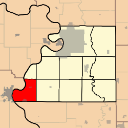
Rush Township is one of twelve townships in Buchanan County, Missouri, USA. As of the 2010 census, its population was 892.
Rush Township | |
|---|---|
Township | |
 | |
| Coordinates: 39°34′27″N 095°02′13″W | |
| Country | United States |
| State | Missouri |
| County | Buchanan |
| Area | |
| • Total | 27.64 sq mi (71.58 km2) |
| • Land | 26.36 sq mi (68.26 km2) |
| • Water | 1.28 sq mi (3.32 km2) 4.64% |
| Elevation | 984 ft (300 m) |
| Population (2010) | |
| • Total | 892 |
| • Density | 33/sq mi (12.8/km2) |
| FIPS code | 29-63542[2] |
| GNIS feature ID | 0766344 |
Rush Township was established in the 1840s.[3]
Geography
Rush Township covers an area of 27.64 square miles (71.6 km2) and contains two incorporated settlements: Lewis and Clark Village and Rushville. It contains four cemeteries: Armstrong, Gore, Hudspeth and Sugar Creek.
Lewis and Clark Lake and Mud Lake are within this township. The streams of Goose Creek, Horseshoe Slough, Little Sugar Creek and Lost Creek run through this township.
Transportation
Rush Township contains one airport or landing strip, East Atchison Airport (historical).
References
- "US Board on Geographic Names". United States Geological Survey. 2007-10-25. Retrieved 2008-01-31.
- "U.S. Census website". United States Census Bureau. Retrieved 2008-01-31.
- "Buchanan County Place Names, 1928–1945 (archived)". The State Historical Society of Missouri. Archived from the original on 24 June 2016. Retrieved 4 September 2016.
{{cite web}}: CS1 maint: bot: original URL status unknown (link)
External links
Municipalities and communities of Buchanan County, Missouri, United States | ||
|---|---|---|
County seat: St. Joseph | ||
| Cities |  | |
| Villages | ||
| Townships | ||
| CDP |
| |
| Other communities |
| |
| Footnotes | ‡This populated place also has portions in an adjacent county or counties | |
| ||
This Buchanan County, Missouri state location article is a stub. You can help Wikipedia by expanding it. |
Текст в блоке "Читать" взят с сайта "Википедия" и доступен по лицензии Creative Commons Attribution-ShareAlike; в отдельных случаях могут действовать дополнительные условия.
Другой контент может иметь иную лицензию. Перед использованием материалов сайта WikiSort.org внимательно изучите правила лицензирования конкретных элементов наполнения сайта.
Другой контент может иметь иную лицензию. Перед использованием материалов сайта WikiSort.org внимательно изучите правила лицензирования конкретных элементов наполнения сайта.
2019-2026
WikiSort.org - проект по пересортировке и дополнению контента Википедии
WikiSort.org - проект по пересортировке и дополнению контента Википедии