world.wikisort.org - USA
Riverdale is an unincorporated community in Sumner County, Kansas, United States.[1] It is located about 6 miles southwest of Belle Plaine at the intersection of N Sand Plum Rd and 77th Ave N, or west of U.S. Route 81 next to the railroad.[1]
Riverdale, Kansas | |
|---|---|
Unincorporated community | |
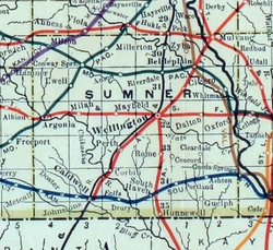 1915 Railroad Map of Sumner County | |
 KDOT map of Sumner County (legend) | |
 Riverdale  Riverdale | |
| Coordinates: 37°22′20″N 97°23′25″W[1] | |
| Country | United States |
| State | Kansas |
| County | Sumner |
| Elevation | 1,309 ft (399 m) |
| Time zone | UTC-6 (CST) |
| • Summer (DST) | UTC-5 (CDT) |
| Area code | 620 |
| FIPS code | 20-60075 [1] |
| GNIS ID | 470163 [1] |
History
A post office was opened in Riverdale in 1887, and remained in operation until it was discontinued in 1973.[2]
A railroad currently passes through the community, north to south, from Wichita to Wellington. Previously a railroad passed through the community, east to west, from Belle Plaine to Conway Springs.
Education
The community is served by Wellington USD 353 public school district.
References
- "Riverdale, Kansas", Geographic Names Information System, United States Geological Survey
- "Kansas Post Offices, 1828-1961, page 2". Kansas Historical Society. Retrieved 27 June 2014.
Further reading
External links
- Sumner County map, KDOT
Municipalities and communities of Sumner County, Kansas, United States | ||
|---|---|---|
County seat: Wellington | ||
| Cities |  | |
| Unincorporated communities | ||
| Ghost towns |
| |
| Footnotes | †This community is designated a Census-Designated Place (CDP) by the United States Census Bureau. ‡This community also has portions in an adjacent county or counties. | |
| ||
Текст в блоке "Читать" взят с сайта "Википедия" и доступен по лицензии Creative Commons Attribution-ShareAlike; в отдельных случаях могут действовать дополнительные условия.
Другой контент может иметь иную лицензию. Перед использованием материалов сайта WikiSort.org внимательно изучите правила лицензирования конкретных элементов наполнения сайта.
Другой контент может иметь иную лицензию. Перед использованием материалов сайта WikiSort.org внимательно изучите правила лицензирования конкретных элементов наполнения сайта.
2019-2026
WikiSort.org - проект по пересортировке и дополнению контента Википедии
WikiSort.org - проект по пересортировке и дополнению контента Википедии