world.wikisort.org - USA
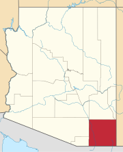
Raso is a populated place situated in Cochise County, Arizona, United States, seven miles northeast of Willcox in Dragoon Pass.[2] It has an estimated elevation of 4,377 feet (1,334 m) above sea level.[1] It was founded in 1881 as a flag station on the Southern Pacific Railroad, originally known as "Railroad Pass", the name was changed in 1903 to Raso, for easier usage in telegraph transmissions. Raso is Spanish for "a flat plain".[3]
Raso, Arizona | |
|---|---|
Populated place | |
 Raso Location within the state of Arizona  Raso Raso (the United States) | |
| Coordinates: 32°20′22″N 109°45′23″W | |
| Country | United States |
| State | Arizona |
| County | Cochise |
| Elevation | 4,377 ft (1,334 m) |
| Time zone | UTC-7 (Mountain (MST)) |
| • Summer (DST) | UTC-7 (MST) |
| Area code | 520 |
| FIPS code | 04-59060 |
| GNIS feature ID | 24575 |
References
- "Feature Detail Report for: Raso". Geographic Names Information System. United States Geological Survey, United States Department of the Interior.
- "Raso (in Cochise County, AZ) Populated Place Profile". AZ Hometown Locator. Retrieved February 25, 2017.
- Barnes, Will Croft (2016). Arizona Place Names. Tucson: University of Arizona Press. p. 356. ISBN 978-0816534951.
Текст в блоке "Читать" взят с сайта "Википедия" и доступен по лицензии Creative Commons Attribution-ShareAlike; в отдельных случаях могут действовать дополнительные условия.
Другой контент может иметь иную лицензию. Перед использованием материалов сайта WikiSort.org внимательно изучите правила лицензирования конкретных элементов наполнения сайта.
Другой контент может иметь иную лицензию. Перед использованием материалов сайта WikiSort.org внимательно изучите правила лицензирования конкретных элементов наполнения сайта.
2019-2025
WikiSort.org - проект по пересортировке и дополнению контента Википедии
WikiSort.org - проект по пересортировке и дополнению контента Википедии
