world.wikisort.org - USA
Putnam is an unincorporated community in Harvey County, Kansas, United States.[1] It is located southwest of Newton at the intersection of West Road and SW 60th Street, along the BNSF Railway.
Putnam, Kansas | |
|---|---|
Unincorporated Community | |
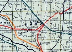 1915 Railroad Map of Harvey County | |
 Putnam Location within the state of Kansas  Putnam Putnam (the United States) | |
| Coordinates: 37.9689005°N 97.3878166°W[1] | |
| Country | United States |
| State | Kansas |
| County | Harvey |
| Township | Sedgwick |
| Elevation | 1,398 ft (426 m) |
| Time zone | UTC-6 (CST) |
| • Summer (DST) | UTC-5 (CDT) |
| Area code | 620 |
| FIPS code | 20-58025 [1] |
| GNIS ID | 484649 [1] |
History
Putnam had a post office from 1891 until 1907.[2]
Geography
Putnam is located at coordinates 37.9689005, -97.3878166 in the state of Kansas.[1] The community is located south of Newton near SW 60th and S. West Road. It was established along a former railroad line between Newton and Wichita.
Education
The community is served by Sedgwick USD 439 public school district.
References
- "Putnam, Kansas", Geographic Names Information System, United States Geological Survey
- "Kansas Post Offices, 1828-1961 (archived)". Kansas Historical Society. Archived from the original on October 9, 2013. Retrieved 11 June 2014.
{{cite web}}: CS1 maint: unfit URL (link)
Further reading
External links
Municipalities and communities of Harvey County, Kansas, United States | ||
|---|---|---|
County seat: Newton | ||
| Cities |  | |
| Unincorporated communities |
| |
| Ghost town |
| |
| Townships |
| |
| Footnotes | ‡This community also has portions in an adjacent county or counties. | |
| ||
Текст в блоке "Читать" взят с сайта "Википедия" и доступен по лицензии Creative Commons Attribution-ShareAlike; в отдельных случаях могут действовать дополнительные условия.
Другой контент может иметь иную лицензию. Перед использованием материалов сайта WikiSort.org внимательно изучите правила лицензирования конкретных элементов наполнения сайта.
Другой контент может иметь иную лицензию. Перед использованием материалов сайта WikiSort.org внимательно изучите правила лицензирования конкретных элементов наполнения сайта.
2019-2026
WikiSort.org - проект по пересортировке и дополнению контента Википедии
WikiSort.org - проект по пересортировке и дополнению контента Википедии