world.wikisort.org - USA
Pantops is a census-designated place in Albemarle County, Virginia.[1]
Pantops | |
|---|---|
CDP | |
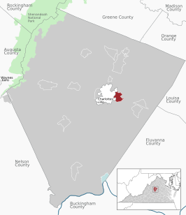 Location of the Pantops CDP within the Albemarle county | |
 Pantops Location within the Commonwealth of Virginia | |
| Coordinates: 38°1′51″N 78°26′41″W | |
| Country | United States |
| State | Virginia |
| County | Albemarle |
| Population (2020) | |
| • Total | 4,682 |
| Time zone | UTC−5 (Eastern (EST)) |
| • Summer (DST) | UTC−4 (EDT) |
| ZIP codes | 22911 |
| FIPS code | 51-60500 |
| GNIS feature ID | 2584899 |
Geography
It is a suburban area located just across the Rivanna River east of Charlottesville, and includes Pantops Mountain.
Demographics
| Historical population | |||
|---|---|---|---|
| Census | Pop. | %± | |
| 2010 | 3,027 | — | |
| 2020 | 4,682 | 54.7% | |
| U.S. Decennial Census 2010[2]2020[3] | |||
The population as of the 2010 Census was 3,027.
References
- "Pantops Census Designated Place". Geographic Names Information System. United States Geological Survey, United States Department of the Interior. Retrieved August 13, 2013.
- "P2 HISPANIC OR LATINO, AND NOT HISPANIC OR LATINO BY RACE - 2010: DEC Redistricting Data (PL 94-171) - Pantops CDP, Virginia". United States Census Bureau.
- "P2 HISPANIC OR LATINO, AND NOT HISPANIC OR LATINO BY RACE - 2020: DEC Redistricting Data (PL 94-171) - Pantops CDP, Virginia". United States Census Bureau.
Wikimedia Commons has media related to Pantops, Virginia.

This Albemarle County, Virginia state location article is a stub. You can help Wikipedia by expanding it. |
Текст в блоке "Читать" взят с сайта "Википедия" и доступен по лицензии Creative Commons Attribution-ShareAlike; в отдельных случаях могут действовать дополнительные условия.
Другой контент может иметь иную лицензию. Перед использованием материалов сайта WikiSort.org внимательно изучите правила лицензирования конкретных элементов наполнения сайта.
Другой контент может иметь иную лицензию. Перед использованием материалов сайта WikiSort.org внимательно изучите правила лицензирования конкретных элементов наполнения сайта.
2019-2026
WikiSort.org - проект по пересортировке и дополнению контента Википедии
WikiSort.org - проект по пересортировке и дополнению контента Википедии