world.wikisort.org - USA
Ozawkie Township is a township in Jefferson County, Kansas, USA. As of the 2000 census, its population was 1,408.
Ozawkie Township | |
|---|---|
Township | |
 Location in Jefferson County | |
| Coordinates: 39°15′35″N 95°25′51″W | |
| Country | United States |
| State | Kansas |
| County | Jefferson |
| Area | |
| • Total | 42.78 sq mi (110.79 km2) |
| • Land | 37.33 sq mi (96.68 km2) |
| • Water | 5.45 sq mi (14.11 km2) 12.74% |
| Elevation | 1,020 ft (311 m) |
| Population (2000) | |
| • Total | 1,408 |
| • Density | 37.7/sq mi (14.6/km2) |
| GNIS feature ID | 0478336 |
Geography
Ozawkie Township covers an area of 42.78 square miles (110.79 square kilometers); of this, 5.45 square miles (14.11 square kilometers) or 12.74 percent is water. The streams of Bowies Branch, Duck Creek, Fishpond Creek and French Creek run through this township.
Cities and towns
Unincorporated towns
- Indian Ridge
- Lake Shore
(This list is based on USGS data and may include former settlements.)
Adjacent townships
- Jefferson Township (northeast)
- Oskaloosa Township (east)
- Fairview Township (south)
- Rock Creek Township (west)
- Delaware Township (northwest)
Cemeteries
The township contains one cemetery, Fairview.
Major highways
- K-4
- K-92
References
External links
Municipalities and communities of Jefferson County, Kansas, United States | ||
|---|---|---|
County seat: Oskaloosa | ||
| Cities | 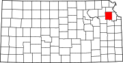 | |
| Unincorporated communities |
| |
| Townships | ||
| Footnotes | †This community is designated a Census-Designated Place (CDP) by the United States Census Bureau. | |
| ||
Authority control | |
|---|---|
| General |
|
| National libraries | |
Текст в блоке "Читать" взят с сайта "Википедия" и доступен по лицензии Creative Commons Attribution-ShareAlike; в отдельных случаях могут действовать дополнительные условия.
Другой контент может иметь иную лицензию. Перед использованием материалов сайта WikiSort.org внимательно изучите правила лицензирования конкретных элементов наполнения сайта.
Другой контент может иметь иную лицензию. Перед использованием материалов сайта WikiSort.org внимательно изучите правила лицензирования конкретных элементов наполнения сайта.
2019-2025
WikiSort.org - проект по пересортировке и дополнению контента Википедии
WikiSort.org - проект по пересортировке и дополнению контента Википедии