world.wikisort.org - USA
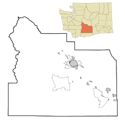
Nass is an unincorporated community in Yakima County, Washington, United States, located approximately one mile east of Granger.
Nass, Washington
Nass Spur[1] | |
|---|---|
Unincorporated community | |
 Nass, Washington Location of Nass, Washington  Nass, Washington Nass, Washington (Washington (state)) | |
| Coordinates: 46°20′19″N 120°08′46″W[2] | |
| Country | United States |
| State | Washington |
| County | Yakima |
| Elevation | 741 ft (226 m) |
| Time zone | UTC-8 (Pacific (PST)) |
| • Summer (DST) | UTC-7 (PDT) |
| ZIP code | 98932 |
| Area code(s) | 509 |
| GNIS feature ID | 1511176[3] |
The community developed around a spur of the Northern Pacific Railway Company line. According to railroad historians, NASS stands for National Agricultural Statistics Service, although the community may have been named after people in the area with a last name of Nass.[1]
References
- "Station Roster Master List: Nass". Northern Pacific Railway Historical Association. Retrieved October 25, 2012.
- "Nass". Geographic Names Information System. United States Geological Survey. Retrieved 2012-10-25.
- "US Board on Geographic Names". United States Geological Survey. 2007-10-25. Retrieved 2008-01-31.
Текст в блоке "Читать" взят с сайта "Википедия" и доступен по лицензии Creative Commons Attribution-ShareAlike; в отдельных случаях могут действовать дополнительные условия.
Другой контент может иметь иную лицензию. Перед использованием материалов сайта WikiSort.org внимательно изучите правила лицензирования конкретных элементов наполнения сайта.
Другой контент может иметь иную лицензию. Перед использованием материалов сайта WikiSort.org внимательно изучите правила лицензирования конкретных элементов наполнения сайта.
2019-2025
WikiSort.org - проект по пересортировке и дополнению контента Википедии
WikiSort.org - проект по пересортировке и дополнению контента Википедии

