world.wikisort.org - USA
Mount Gilead, Tennessee (sometimes called Mt. Gilead) is an unincorporated community located in Henderson County, Tennessee, United States at latitude 35.766 and longitude -88.54, at an elevation of 561 feet.[1] It is on O'Brien Road west of Tennessee Highway 104, approximately 8 kilometres south-southeast of Cedar Grove, Tennessee.[2] As late as 1926, Mount Gilead had its own school.[3]
Mount Gilead, Tennessee | |
|---|---|
Unincorporated community | |
 Mount Gilead  Mount Gilead | |
| Coordinates: 35°45′57″N 88°32′23″W | |
| Country | United States |
| State | Tennessee |
| County | Henderson |
| Elevation | 561 ft (171 m) |
| Time zone | UTC-6 (Central (CST)) |
| • Summer (DST) | UTC-5 (CDT) |
| Area code(s) | 731 |
| GNIS feature ID | 1294612[1] |
References
Municipalities and communities of Henderson County, Tennessee, United States | ||
|---|---|---|
County seat: Lexington | ||
| Cities | 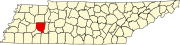 | |
| Towns |
| |
| CDPs |
| |
| Other communities |
| |
| Footnotes | ‡This populated place also has portions in an adjacent county or counties | |
| ||
This Henderson County, Tennessee geography–related article is a stub. You can help Wikipedia by expanding it. |
Текст в блоке "Читать" взят с сайта "Википедия" и доступен по лицензии Creative Commons Attribution-ShareAlike; в отдельных случаях могут действовать дополнительные условия.
Другой контент может иметь иную лицензию. Перед использованием материалов сайта WikiSort.org внимательно изучите правила лицензирования конкретных элементов наполнения сайта.
Другой контент может иметь иную лицензию. Перед использованием материалов сайта WikiSort.org внимательно изучите правила лицензирования конкретных элементов наполнения сайта.
2019-2026
WikiSort.org - проект по пересортировке и дополнению контента Википедии
WikiSort.org - проект по пересортировке и дополнению контента Википедии