world.wikisort.org - USA
Moor is a ghost town in Ceder Pass in Elko County, Nevada, United States.[1] It is located along Interstate 80 between Wells and West Wendover.
Moor, Nevada | |
|---|---|
Ghost town | |
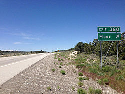
 Moor exit on Interstate 80 | |
 Moor, Nevada Location in the state of Nevada  Moor, Nevada Moor, Nevada (the United States) | |
| Coordinates: 41°07′02″N 114°48′54″W | |
| Country | United States |
| State | Nevada |
| County | Elko |
| Elevation | 6,158 ft (1,877 m) |
| Time zone | UTC-8 (PST) |
| • Summer (DST) | UTC-7 (PDT) |
History
The first settlement at Moor was made in 1869.[2] Variant names were "Moor Siding", "Moores", and "Moors".[1] The community was named after a railroad employee.[3] In 1941, Moor had 17 inhabitants. [2] Other than some remnants of building foundations and aged debris, little remains of the town today.
References
- U.S. Geological Survey Geographic Names Information System: Moor
- Federal Writers' Project (1941). Origin of Place Names: Nevada (PDF). W.P.A. p. 27.
- Carlson, Helen S. (1974). Nevada Place Names: A Geographical Dictionary. University of Nevada Press. p. 171. ISBN 978-0-87417-094-8.
External links
![]() Media related to Moor, Nevada at Wikimedia Commons
Media related to Moor, Nevada at Wikimedia Commons
Текст в блоке "Читать" взят с сайта "Википедия" и доступен по лицензии Creative Commons Attribution-ShareAlike; в отдельных случаях могут действовать дополнительные условия.
Другой контент может иметь иную лицензию. Перед использованием материалов сайта WikiSort.org внимательно изучите правила лицензирования конкретных элементов наполнения сайта.
Другой контент может иметь иную лицензию. Перед использованием материалов сайта WikiSort.org внимательно изучите правила лицензирования конкретных элементов наполнения сайта.
2019-2025
WikiSort.org - проект по пересортировке и дополнению контента Википедии
WikiSort.org - проект по пересортировке и дополнению контента Википедии
