world.wikisort.org - USA
Misquamicut is a census-designated place and fire district in southern Washington County, Rhode Island. It is part of the town of Westerly and is a census-designated place.[5] The population was listed as 390 in 2010.[6]
Misquamicut, Rhode Island | |
|---|---|
Census-designated place | |
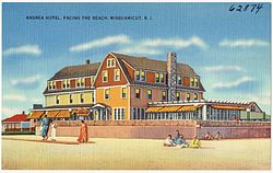
 Andrea Hotel, c.1930s | |
 Misquamicut, Rhode Island Location in the state of Rhode Island  Misquamicut, Rhode Island Misquamicut, Rhode Island (the United States) | |
| Coordinates: 41°19′26″N 71°49′19″W | |
| Country | United States |
| State | Rhode Island |
| County | Washington |
| Area | |
| • Total | 1.25 sq mi (3.23 km2) |
| • Land | 1.17 sq mi (3.04 km2) |
| • Water | 0.07 sq mi (0.19 km2) |
| Elevation | 3 ft (1 m) |
| Population (2020)[2] | |
| • Total | 434 |
| • Density | 369.99/sq mi (142.89/km2) |
| Time zone | UTC-5 (Eastern (EST)) |
| • Summer (DST) | UTC-4 (EDT) |
| ZIP code | 02891 |
| Area code | 401 |
| FIPS code | 44-46000[3] |
| GNIS feature ID | 1217591[4] |
Name
Misquamicut is a word in the Narragansett language or in another Algonquian language closely related to Narragansett. It can be derived from the roots mish 'red' + kwam 'fish' + k (plural) + -t 'at', meaning 'At the Place of the Red Fish,' that is, 'At the Salmon Place'.[7]
History
The district was once known as Pleasant View. The land was purchased from Chief Sosoa of the Montauks in 1661. The name was changed from Pleasant View to Misquamicut in 1928. The area suffered a series of devastating hurricanes that wiped out beach homes, hotels, and other structures in 1938, 1944, and 1954. A portion of the oceanfront became Misquamicut State Beach in 1959.[8]

Atlantic Beach Park (41.324438°N 71.794386°W) is a privately-operated amusement center with 12 acres (49,000 m2) of land and buildings within the Misquamicut section of beachfront.[9][10][11] It lies south of Misquamicut State Beach[12] and north of Winnapaug Pond, a source of Rhode Island quahogs (clams) and bay scallops. The first parcel of this property was purchased in 1920 from the Norwich and Westerly Railway by Julia and Harry Trefes. Subsequent purchases by them and their two sons eventually totaled 12 acres (49,000 m2). The property is still owned and operated by the Trefes family. This section of Misquamicut was originally called "Atlantic Beach Casino".[13] It retains a carousel with antique band organ,[14][15] kiddie rides, bumper cars, game room, and ice cream stand.[16] More recently, mini-golf, go-karts, batting cage, water slides, gift shop, and more have been added.[17]
Geography
According to the U.S. Census Bureau, Misquamicut has a total area of 1.25 mi2 (3.23 km2), of which 1.17 mi2 (3.04 km2) is land and 0.075 mi2 (0.19 km2), or 6.0%, is water.[18]
Demographics
| Historical population | |||
|---|---|---|---|
| Census | Pop. | %± | |
| 2020 | 434 | — | |
| U.S. Decennial Census[19] | |||
References
- "ArcGIS REST Services Directory". United States Census Bureau. Retrieved October 12, 2022.
- "Census Population API". United States Census Bureau. Retrieved Oct 12, 2022.
- "U.S. Census website". United States Census Bureau. Retrieved 2020-07-19.
- "US Board on Geographic Names". United States Geological Survey. Retrieved 2020-07-19.
- U.S. Geological Survey Geographic Names Information System: Misquamicut, Rhode Island
- "Population and Housing Unit Counts: Rhode Island" (PDF). U.S. Census Bureau. p. 11. Retrieved September 1, 2014.
- Francis Joseph O'Brien, Jr. (Moondancer) and Julianne Jennings (Strong Woman), An Introduction to the Narragansett Language: A Study of Roger Williams' A Key into the Language of America. Newport, Rhode Island: Aquidneck Indian Council, 2001, PP. 131, 136; https://www.scribd.com/doc/299109237/Introduction-to-the-Narragansett-Language , accessed September 29th, 2017
- "Misquamicut State Beach History". State of Rhode Division of Parks & Recreation. Retrieved September 1, 2014.
- "Your Kids Will Have A Blast At This Miniature Amusement Park In Rhode Island Made Just For Them". www.onlyinyourstate.com. 2019-03-26. Retrieved 2020-07-19.
{{cite web}}: CS1 maint: url-status (link) - "Rhode Island's Classic Carousels: A Seaside Tour". www.wsj.com. 2017-09-01. Retrieved 2020-07-19.
{{cite web}}: CS1 maint: url-status (link) - "Amusement Parks In Rhode Island: A Huffington Post Travel Guide". www.huffpost.com. 2017-12-06. Retrieved 2020-07-19.
{{cite web}}: CS1 maint: url-status (link) - Tobyne, Dan (June 15, 2016). Beachcomber's Guide to the Northeast. Down East Books. ISBN 9781608934041 – via Google Books.
- Gentile, Donald L.; Gordon, Bernard L. (April 12, 2010). Misquamicut. Arcadia Publishing. ISBN 9781439637579 – via Google Books.
- "Atlantic Beach Park". WESTERLY RI. February 26, 2016.
- "National Carousel Association - The Atlantic Beach Park Carousel - Atlantic Beach Park Carousel". carousels.org.
- "The 7 Best Beaches in Rhode Island". www.afar.com. 2019-03-20. Retrieved 2019-07-19.
{{cite web}}: CS1 maint: url-status (link) - "Things to Do in Misquamicut, Rhode Island". www.traveltips.usatoday.com. Retrieved 2020-07-19.
{{cite web}}: CS1 maint: url-status (link) - "US Gazetteer files: 2019". United States Census Bureau. Retrieved 2020-07-19.
- "Census of Population and Housing". Census.gov. Retrieved June 4, 2016.
External links
Другой контент может иметь иную лицензию. Перед использованием материалов сайта WikiSort.org внимательно изучите правила лицензирования конкретных элементов наполнения сайта.
WikiSort.org - проект по пересортировке и дополнению контента Википедии
