world.wikisort.org - USA
Mililani Mauka is a census-designated place (CDP) in Honolulu County, Hawaii on the island of Oʻahu, Hawaii, United States. As of the 2020 census, the CDP had a population of 21,075.
Mililani Mauka | |
|---|---|
Census-designated place | |
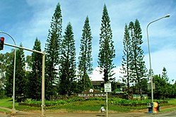
 Mililani Mauka, the newer area of Mililani located on the mountain, or mauka, side of the H-2 freeway | |
 Mililani Mauka | |
| Coordinates: 21°28′32″N 157°59′40″W | |
| Country | United States |
| State | Hawaii |
| Area | |
| • Total | 3.99 sq mi (10.35 km2) |
| • Land | 3.99 sq mi (10.35 km2) |
| • Water | 0.00 sq mi (0.00 km2) |
| Elevation | 880 ft (270 m) |
| Population (2020) | |
| • Total | 21,075 |
| • Density | 5,276.66/sq mi (2,037.19/km2) |
| Time zone | UTC-10 (Hawaii-Aleutian) |
| Area code(s) | 808 |
| FIPS code | 15-51000 |
History
Mililani Mauka is a planned community adjacent to Mililani Town, both situated about 10 miles (16 km) northwest of the center of Honolulu. Ground was broken for Mililani Mauka on April 6, 1990, east of Interstate H-2 from Mililani Town. The first homeowners moved into Mauka in 1992. The community is the future site of the Oahu Arts Center.
Geography
Mililani Mauka is located at 21°28′32″N 157°59′40″W (21.4756, -157.9947). According to the United States Census Bureau, the CDP has a total area of 4.0 square miles (10.3 km2), all land.[2] Mililani Mauka lies within the ʻEwa Moku on Oʻahu, more specifically the Waipiʻo Ahupuaʻa.[3]
Demographics
| Historical population | |||
|---|---|---|---|
| Census | Pop. | %± | |
| 2020 | 21,075 | — | |
| U.S. Decennial Census[4] | |||
Education
Hawaii Department of Education operates public schools within the CDP.[5]
Mililani Mauka is home to Mililani Mauka Elementary School,[6] Mililani ʻIke Elementary School,[7] and Mililani Middle School.[8]
References
- "2020 U.S. Gazetteer Files". United States Census Bureau. Retrieved December 18, 2021.
- "Geographic Identifiers: 2010 Demographic Profile Data (G001): Maililani Mauka CDP, Hawaii". United States Census Bureau. Retrieved May 23, 2012.
- Julie Stewart Williams, From The Mountains To The Sea Early Hawaiian Life (Kamehameha Schools Press, 1997), 9.
- "Census of Population and Housing". Census.gov. Retrieved June 4, 2016.
- "2010 CENSUS - CENSUS BLOCK MAP: Mililani Mauka CDP, HI" (PDF). U.S. Census Bureau. Retrieved 2020-10-10. - Compare this to locations of schools and universities.
- "Home". Mililani Mauka Elementary School. Retrieved 2020-10-10.
95-1111 Makaikai Street Mililani, HI 96789
- "Home". Mililani ʻIke Elementary School. Retrieved 2020-10-10.
95-1330 Lehiwa Drive Mililani, HI 96789
- , Mililani Middle School website, retrieved on April 9, 2018. "95-1140 LEHIWA DRIVE | MILILANI, HI 96789"
Другой контент может иметь иную лицензию. Перед использованием материалов сайта WikiSort.org внимательно изучите правила лицензирования конкретных элементов наполнения сайта.
WikiSort.org - проект по пересортировке и дополнению контента Википедии
