world.wikisort.org - USA
Martinton Township is one of twenty-six townships in Iroquois County, Illinois, USA. As of the 2010 census, its population was 943 and it contained 460 housing units.[2] Buchanan Township formed from a portion of Papineau Township, then known as Wygant Township, in September 1857; its name was changed to Martinton Township on an unknown date.
Martinton Township | |
|---|---|
Township | |
 Fields along U.S. Route 52, southwest of Martinton | |
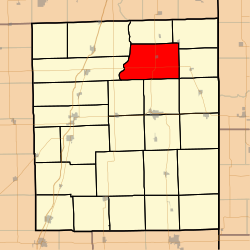 Location in Iroquois County | |
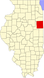 Iroquois County's location in Illinois | |
| Coordinates: 40°54′04″N 87°44′18″W | |
| Country | United States |
| State | Illinois |
| County | Iroquois |
| Established | September 1857 |
| Area | |
| • Total | 54.41 sq mi (140.9 km2) |
| • Land | 54.22 sq mi (140.4 km2) |
| • Water | 0.19 sq mi (0.5 km2) 0.35% |
| Elevation | 623 ft (190 m) |
| Population (2010) | |
| • Estimate (2016)[1] | 904 |
| • Density | 17.4/sq mi (6.7/km2) |
| Time zone | UTC-6 (CST) |
| • Summer (DST) | UTC-5 (CDT) |
| ZIP codes | 60912, 60931, 60951, 60970 |
| FIPS code | 17-075-47293 |
Geography
According to the 2010 census, the township has a total area of 54.41 square miles (140.9 km2), of which 54.22 square miles (140.4 km2) (or 99.65%) is land and 0.19 square miles (0.49 km2) (or 0.35%) is water.[2]
Cities, towns, villages
- Martinton
Extinct towns
- Freedville at 40.860868°N 87.74309°W
Cemeteries
The township contains these four cemeteries: Greentown, Mount Olivet, Old Burg and Teege.
Major highways
 U.S. Route 52
 Illinois Route 1
Demographics
| Historical population | |||
|---|---|---|---|
| Census | Pop. | %± | |
| 2016 (est.) | 904 | [1] | |
| U.S. Decennial Census[3] | |||
School districts
- Donovan Community Unit School District 3
- Iroquois County Community Unit School District 9
Political districts
- Illinois' 15th congressional district
- State House District 79
- State Senate District 40
References
- "Martinton Township, Iroquois County, Illinois". Geographic Names Information System. United States Geological Survey. Retrieved 2010-01-17.
- United States Census Bureau 2007 TIGER/Line Shapefiles
- United States National Atlas
- "Population and Housing Unit Estimates". Retrieved June 9, 2017.
- "Population, Housing Units, Area, and Density: 2010 - County -- County Subdivision and Place -- 2010 Census Summary File 1". United States Census. Archived from the original on 2020-02-12. Retrieved 2013-05-28.
- "Census of Population and Housing". Census.gov. Retrieved June 4, 2016.
External links
Places adjacent to Martinton Township, Iroquois County, Illinois | ||||||||||||||||
|---|---|---|---|---|---|---|---|---|---|---|---|---|---|---|---|---|
| ||||||||||||||||
Municipalities and communities of Iroquois County, Illinois, United States | ||
|---|---|---|
County seat: Watseka | ||
| Cities |
|  |
| Villages |
| |
| Townships |
| |
| Unincorporated communities |
| |
| Footnotes | ‡This populated place also has portions in an adjacent county or counties | |
| ||
Текст в блоке "Читать" взят с сайта "Википедия" и доступен по лицензии Creative Commons Attribution-ShareAlike; в отдельных случаях могут действовать дополнительные условия.
Другой контент может иметь иную лицензию. Перед использованием материалов сайта WikiSort.org внимательно изучите правила лицензирования конкретных элементов наполнения сайта.
Другой контент может иметь иную лицензию. Перед использованием материалов сайта WikiSort.org внимательно изучите правила лицензирования конкретных элементов наполнения сайта.
2019-2025
WikiSort.org - проект по пересортировке и дополнению контента Википедии
WikiSort.org - проект по пересортировке и дополнению контента Википедии