world.wikisort.org - USA
Manchester is a town in Meriwether and Talbot Counties in the U.S. state of Georgia, although primarily in Meriwether. The population was 4,230 at the 2010 census. CSX Transportation runs a railroad yard in Manchester.
Manchester, Georgia | |
|---|---|
City | |
 Manchester, Georgia in 2012. | |
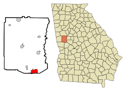 Location in Meriwether County and the state of Georgia | |
| Coordinates: 32°51′22″N 84°37′3″W | |
| Country | United States |
| State | Georgia |
| Counties | Meriwether, Talbot |
| Area | |
| • Total | 8.05 sq mi (20.85 km2) |
| • Land | 8.01 sq mi (20.75 km2) |
| • Water | 0.04 sq mi (0.09 km2) |
| Elevation | 883 ft (269 m) |
| Population (2020) | |
| • Total | 3,584 |
| • Density | 447.27/sq mi (172.69/km2) |
| Time zone | UTC-5 (Eastern (EST)) |
| • Summer (DST) | UTC-4 (EDT) |
| ZIP code | 31816 |
| Area code | 706 |
| FIPS code | 13-49532[2] |
| GNIS feature ID | 0317652[3] |
| Website | http://manchester-ga.gov/ |
History
Manchester was founded in 1907, when the Atlanta, Birmingham and Atlantic Railroad was extended to that point, Later Atlantic Coast Line and Seaboard Coast Line.[4] The Georgia General Assembly incorporated Manchester as a city in 1909.[5] The city was named after Manchester, in England.[4]
In 2019, CSX Transportation demolished the historic Manchester Yard Office in order to make way for a new, larger, yard facilities building.
Geography
Manchester is in west central Georgia along Georgia State Route 85, which leads southwest 39 miles (63 km) to Columbus and northeast 10 miles (16 km) to Woodbury. Georgia 85 meets Georgia State Route 190 south of the city, which leads west 18 miles (29 km) to Pine Mountain. Georgia 85 also meets Georgia State Route 41 in the city, which leads southeast 7 miles (11 km) to Woodland and northwest 4 miles (6 km) to Warm Springs.
Demographics
| Historical population | |||
|---|---|---|---|
| Census | Pop. | %± | |
| 1910 | 922 | — | |
| 1920 | 2,776 | 201.1% | |
| 1930 | 3,745 | 34.9% | |
| 1940 | 3,462 | −7.6% | |
| 1950 | 4,036 | 16.6% | |
| 1960 | 4,115 | 2.0% | |
| 1970 | 4,779 | 16.1% | |
| 1980 | 4,796 | 0.4% | |
| 1990 | 4,104 | −14.4% | |
| 2000 | 3,988 | −2.8% | |
| 2010 | 4,230 | 6.1% | |
| 2020 | 3,584 | −15.3% | |
| U.S. Decennial Census[6] | |||

2020 census
| Race | Num. | Perc. |
|---|---|---|
| White (non-Hispanic) | 1,666 | 46.48% |
| Black or African American (non-Hispanic) | 1,713 | 47.8% |
| Native American | 3 | 0.08% |
| Asian | 19 | 0.53% |
| Pacific Islander | 2 | 0.06% |
| Other/Mixed | 108 | 3.01% |
| Hispanic or Latino | 73 | 2.04% |
As of the 2020 United States census, there were 3,584 people, 1,494 households, and 1,056 families residing in the city.
2000 census
As of the census[2] of 2000, there were 3,769 people, 1,629 households, and 1,057 families residing in the city. The population density was 698.1 inhabitants per square mile (269.5/km2). There were 1,853 housing units at an average density of 324.4 per square mile (125.3/km2). The racial makeup of the city was 56.22% White, 42.23% African American, 0.33% Native American, 0.65% Asian, 0.10% from other races, and 0.48% from two or more races. Hispanic or Latino of any race were 0.70% of the population.
There were 1,629 households, out of which 28.7% had children under the age of 18 living with them, 39.5% were married couples living together, 21.4% had a female householder with no husband present, and 35.1% were non-families. 31.4% of all households were made up of individuals, and 14.5% had someone living alone who was 65 years of age or older. The average household size was 2.45 and the average family size was 3.09.
In the city, the population was spread out, with 27.9% under the age of 18, 8.6% from 18 to 24, 25.4% from 25 to 44, 21.7% from 45 to 64, and 16.4% who were 65 years of age or older. The median age was 37 years. For every 100 females, there were 82.3 males. For every 100 females age 18 and over, there were 75.0 males.
The median income for a household in the city was $23,983, and the median income for a family was $31,988. Males had a median income of $25,942 versus $21,484 for females. The per capita income for the city was $16,130. About 17.8% of families and 25.0% of the population were below the poverty line, including 37.0% of those under age 18 and 13.7% of those age 65 or over.
Notable people
- Novelist Stuart Woods.[8] Manchester, dubbed Delano, was the setting for his first best-seller, Chiefs, and most of his subsequent books have a character who comes from the city.
- 5x Grammy nominated and Grammy award winning record producer and songwriter D. Arcelious Harris p/k/a Swagg R'Celious
- Former Clemson and Super Bowl-winning New York Jets football player Bill Mathis.
- NCAA Basketball Star Korvotney Barber (Auburn)
- State Representative Leonard R. "Nookie" Meadows
- Georgia Radio Hall of Fame inductee Wade Collier (Bear O'Brien)
References
- "2020 U.S. Gazetteer Files". United States Census Bureau. Retrieved December 18, 2021.
- "U.S. Census website". United States Census Bureau. Retrieved December 1, 2008.
- "US Board on Geographic Names". United States Geological Survey. October 25, 2007. Retrieved January 1, 2008.
- Krakow, Kenneth K. (1975). Georgia Place-Names: Their History and Origins (PDF). Macon, GA: Winship Press. p. 143. ISBN 0-915430-00-2.
- Acts and Resolutons of the General Assembly of the State of Georgia. State printer. 1909. p. 1071.
- "Census of Population and Housing". Census.gov. Retrieved June 4, 2015.
- "Explore Census Data". data.census.gov. Retrieved 2021-12-14.
- "Stuart Woods Official Website". www.stuartwoods.com. Archived from the original on 3 October 2002. Retrieved 22 May 2022.
External links
Municipalities and communities of Talbot County, Georgia, United States | ||
|---|---|---|
County seat: Talbotton | ||
| Cities |  | |
| Towns | ||
| CDP | ||
| Other unincorporated communities |
| |
| Footnotes | ‡This populated place also has portions in an adjacent county or counties | |
| ||
Municipalities and communities of Meriwether County, Georgia, United States | ||
|---|---|---|
County seat: Greenville | ||
| Cities |  | |
| Towns |
| |
| Unincorporated communities | ||
| Footnotes | ‡This populated place also has portions in an adjacent county or counties | |
| ||
Authority control | |
|---|---|
| General | |
| National libraries | |
На других языках
[de] Manchester (Georgia)
Manchester ist eine Stadt in den Countys Meriwether und Talbot im US-Bundesstaat Georgia mit 4230 Einwohnern (Stand: 2010).- [en] Manchester, Georgia
Другой контент может иметь иную лицензию. Перед использованием материалов сайта WikiSort.org внимательно изучите правила лицензирования конкретных элементов наполнения сайта.
WikiSort.org - проект по пересортировке и дополнению контента Википедии