world.wikisort.org - USA
Makena is a census-designated place (CDP) in Maui County, Hawaiʻi, United States. As of the 2010 census, it had a population of 99.[2] Prior to 2010, the area was part of the Wailea-Makena census-designated place.
Makena, Hawaii | |
|---|---|
Census-designated place | |
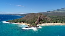
 Makena State Park, "Big Beach" side. | |
| Coordinates: 20°39′14″N 156°26′25″W | |
| Country | United States |
| State | Hawaii |
| County | Maui |
| Area | |
| • Total | 11.54 sq mi (29.89 km2) |
| • Land | 9.47 sq mi (24.53 km2) |
| • Water | 2.07 sq mi (5.36 km2) |
| Population (2020) | |
| • Total | 196 |
| • Density | 20.70/sq mi (7.99/km2) |
| Time zone | UTC-10 (Hawaii-Aleutian) |
| Area code(s) | 808 |
| FIPS code | 15-48350 |
Geography

Makena is located at 20°39′14″N 156°26′25″W (20.6539, -156.4403).[3]
According to the United States Census Bureau, the CDP has a total area of 11.5 square miles (29.9 km2), of which 9.5 square miles (24.5 km2) is land and 2.1 square miles (5.4 km2), or 17.93%, is water.[4]
Climate
| Climate data for Makena, Hawaii (Makena Golf Course) 1991–2020 normals, extremes 1982–present | |||||||||||||
|---|---|---|---|---|---|---|---|---|---|---|---|---|---|
| Month | Jan | Feb | Mar | Apr | May | Jun | Jul | Aug | Sep | Oct | Nov | Dec | Year |
| Record high °F (°C) | 90 (32) |
87 (31) |
89 (32) |
89 (32) |
90 (32) |
91 (33) |
93 (34) |
94 (34) |
94 (34) |
94 (34) |
95 (35) |
91 (33) |
95 (35) |
| Average high °F (°C) | 80.1 (26.7) |
79.9 (26.6) |
81.2 (27.3) |
83.1 (28.4) |
84.3 (29.1) |
85.9 (29.9) |
87.1 (30.6) |
87.3 (30.7) |
86.8 (30.4) |
86.1 (30.1) |
83.4 (28.6) |
81.2 (27.3) |
83.9 (28.8) |
| Daily mean °F (°C) | 71.8 (22.1) |
71.4 (21.9) |
72.3 (22.4) |
73.8 (23.2) |
75.0 (23.9) |
76.8 (24.9) |
78.1 (25.6) |
78.3 (25.7) |
78.0 (25.6) |
77.2 (25.1) |
75.1 (23.9) |
73.0 (22.8) |
75.1 (23.9) |
| Average low °F (°C) | 63.5 (17.5) |
63.0 (17.2) |
63.5 (17.5) |
64.5 (18.1) |
65.8 (18.8) |
67.8 (19.9) |
69.1 (20.6) |
69.2 (20.7) |
69.1 (20.6) |
68.4 (20.2) |
66.9 (19.4) |
64.8 (18.2) |
66.3 (19.1) |
| Record low °F (°C) | 54 (12) |
54 (12) |
54 (12) |
58 (14) |
54 (12) |
62 (17) |
62 (17) |
62 (17) |
61 (16) |
61 (16) |
56 (13) |
57 (14) |
54 (12) |
| Average rainfall inches (mm) | 2.48 (63) |
1.28 (33) |
1.99 (51) |
0.75 (19) |
1.08 (27) |
0.38 (9.7) |
0.77 (20) |
1.21 (31) |
1.11 (28) |
1.55 (39) |
1.24 (31) |
1.85 (47) |
15.70 (399) |
| Average rainy days (≥ 0.01 in) | 5.5 | 4.6 | 4.9 | 3.2 | 3.9 | 2.0 | 3.3 | 2.7 | 5.0 | 2.9 | 4.2 | 4.9 | 47.1 |
| Source: NOAA[5][6] | |||||||||||||
Demographics
| Historical population | |||
|---|---|---|---|
| Census | Pop. | %± | |
| 2020 | 196 | — | |
| U.S. Decennial Census[7] | |||
See also
- List of beaches in Hawaii#Maui
- Makena Beach & Golf Resort - A hotel/ resort in the Makena area.
References
- "2020 U.S. Gazetteer Files". United States Census Bureau. Retrieved December 18, 2021.
- "Profile of General Population and Housing Characteristics: 2010 Demographic Profile Data (DP-1): Makena CDP, Hawaii". United States Census Bureau. Retrieved December 29, 2011.
- "US Gazetteer files: 2010, 2000, and 1990". United States Census Bureau. 2011-02-12. Retrieved 2011-04-23.
- "Geographic Identifiers: 2010 Demographic Profile Data (G001): Makena CDP, Hawaii". United States Census Bureau. Retrieved December 29, 2011.
- "NowData - NOAA Online Weather Data". National Oceanic and Atmospheric Administration. Retrieved September 13, 2021.
- "Station: Makena Golf Crs 249.1, HI". U.S. Climate Normals 2020: U.S. Monthly Climate Normals (1991-2020). National Oceanic and Atmospheric Administration. Retrieved September 13, 2021.
- "Census of Population and Housing". Census.gov. Retrieved June 4, 2016.
External links
 Media related to Makena, Hawaii at Wikimedia Commons
- Daily newspaper
На других языках
- [en] Makena, Hawaii
[ru] Макена
Макена (гав. Makena) — статистически обособленная местность в округе Мауи (штат Гавайи, США).[2] До 2010 года являлась частью статистически обособленной местности Ваилеа-Макена.Текст в блоке "Читать" взят с сайта "Википедия" и доступен по лицензии Creative Commons Attribution-ShareAlike; в отдельных случаях могут действовать дополнительные условия.
Другой контент может иметь иную лицензию. Перед использованием материалов сайта WikiSort.org внимательно изучите правила лицензирования конкретных элементов наполнения сайта.
Другой контент может иметь иную лицензию. Перед использованием материалов сайта WikiSort.org внимательно изучите правила лицензирования конкретных элементов наполнения сайта.
2019-2025
WikiSort.org - проект по пересортировке и дополнению контента Википедии
WikiSort.org - проект по пересортировке и дополнению контента Википедии
