world.wikisort.org - USA
Madison was a town in Dane County, Wisconsin, United States. The population was 6,236 at the 2020 census. The town, although once larger, was broken up into discontinuous fragments by the much larger city of Madison, and was dissolved by merging parts of the town with the cities of Madison and Fitchburg on October 30th, 2022. The majority of the town's territory was situated along Highway 12/18, comprising several neighborhoods situated between the south side of the city of Madison, and the north side of the city of Fitchburg. The town also had territory on the north side of Madison near the border with Maple Bluff, as well as a few lots on the west side of Madison near Whitney Way. The Alliant Energy Center was situated within the Town of Madison. Despite its status as an unincorporated community, the Town of Madison provided a variety of services to its residents which are typically only found in incorporated cities and villages, including police, fire and emergency medical services; sewer and water utilities; and three public parks.
Madison, Wisconsin | |
|---|---|
Town | |
 Town of Madison Municipal Building | |
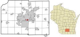 Location in Dane County and the state of Wisconsin. | |
 Madison  Madison | |
| Coordinates: 43°2′32″N 89°24′5″W | |
| Country | |
| State | |
| County | Dane |
| Area | |
| • Total | 1.5 sq mi (4 km2) |
| • Land | 1.48 sq mi (3.8 km2) |
| • Water | 0.01 sq mi (0.03 km2) |
| Elevation | 846 ft (258 m) |
| Population (2020) | |
| • Total | 6,236 |
| • Density | 4,324.1/sq mi (1,669.5/km2) |
| Time zone | UTC-6 (Central (CST)) |
| • Summer (DST) | UTC-5 (CDT) |
| Area code | 608 |
| FIPS code | 55-48025[2] |
| GNIS feature ID | 1583626[1] |
History
The original Town of Madison encompassed approximately 36 square miles (93 km2), and was organized on February 2, 1846.[3][4] In 1856 the Wisconsin Legislature chartered the city of Madison, leaving the remainder as the town.[5] Most of this land was gradually incorporated into various municipalities, especially the city of Madison, leaving the town as a collection of discontinuous areas subject to annexation. In the wake of continued controversy and an effort in the state legislature to simply abolish the town[citation needed], an agreement was reached in 2003 to provide for the incorporation of the remaining portions of the town (by then down to less than 3.9 square miles (10 km2), including bodies of water) into the city of Madison and the city of Fitchburg on October 31, 2022.[6]
Geography
According to the United States Census Bureau, the town had a total area of 1.5 square miles (3.9 km2), of which 1.4 square miles (3.6 km2) was land and 0.01 square miles (0.026 km2) (0.67%) was water.
Demographics
| Historical population | |||
|---|---|---|---|
| Census | Pop. | %± | |
| 1870 | 857 | — | |
| 1880 | 735 | −14.2% | |
| 1890 | 919 | 25.0% | |
| 1900 | 1,567 | 70.5% | |
| 1910 | 1,705 | 8.8% | |
| 1920 | 2,327 | 36.5% | |
| 1930 | 3,355 | 44.2% | |
| 1940 | 4,638 | 38.2% | |
| 1950 | 4,195 | −9.6% | |
| 1960 | 4,925 | 17.4% | |
| 1970 | 4,568 | −7.2% | |
| 1980 | 6,162 | 34.9% | |
| 1990 | 6,442 | 4.5% | |
| 2000 | 7,005 | 8.7% | |
| 2010 | 6,279 | −10.4% | |
| 2020 | 6,277 | 0.0% | |
| U.S. Decennial Census[7] | |||
As of the census[8] of 2010, there were 6,279 people, 2,852 households, and 1,212 families residing in the town. The population density was 4,234.1 people per square mile (1,669.5/km2). There were 3,069 housing units at an average density of 2,069.5 per square mile (799/km2). The racial makeup of the town was 54.6% White, 20.1% Black or African American, 0.9% Native American, 5.9% Asian, 0.0% Pacific Islander, 13.7% from other races, and 4.8% from two or more races. 28.0% of the population were Hispanic or Latino of any race.
There were 2,852 households, out of which 25.4% had children under the age of 18 living with them, 22.6% were married couples living together, 13.6% had a female householder with no husband present, and 57.5% were non-families. 41.8% of all households were made up of individuals, and 3.7% had someone living alone who was 65 years of age or older. The average household size was 2.20 and the average family size was 3.19.
In the town, the population was spread out, with 23.2% under the age of 18, 16.8% from 18 to 25, 36.8% from 25 to 44, 18.8% from 45 to 64, and 4.4% who were 65 years of age or older. The median age was 28.6 years. For every 100 females, there were 110.9 males. For every 100 females age 18 and over, there were 109.8 males.
The median income for a household in the town was $29,766, and the median income for a family was $37,344. Males had a median income of $31,450 versus $25,795 for females. The per capita income for the town was $19,566. About 22.0% of families and 25.9% of the population were below the poverty line, including 51.2% of those under age 18 and 11.1% of those age 65 or over.[9]
References
- "US Board on Geographic Names". United States Geological Survey. 2007-10-25. Retrieved 2008-01-31.
- "U.S. Census website". United States Census Bureau. Retrieved 2008-01-31.
- Madison, Election precinct of, Dane Co
- Madison, Town of, Dane Co
- Tenney, H.A. Madison, Dane County and Surrounding Towns; being a history and guide to places of scenic beauty and historical note found in the towns of Dane County and surroundings, including the organization of the towns, and early intercourse of the settlers with the Indians, their camps, trails, mounds, etc. with a complete list of county supervisors and officers, and legislative members, Madison Village and City Council. Madison: 1877; pp. 543-558.
- "2003 City of Madison, City of Fitchburg and Town of Madison Cooperative Plan" (PDF). Archived from the original (PDF) on 2014-12-05. Retrieved 2014-11-29.
- United States Census Bureau. "Census of Population and Housing". Archived from the original on October 3, 2014. Retrieved October 26, 2022.
- "U.S. Census website" United States Census Bureau. Retrieved 2012-06-20.
- "U.S. Census website" United States Census Bureau, 2006-2010 American Community Survey. Retrieved 2012-06-20.
External links
- Town of Madison government website
- Madison – Town of Madison – Fitchburg boundary change map
- Where's the Town of Madison?
City of Madison and Metropolitan Area | ||||||
|---|---|---|---|---|---|---|
| Surrounding communities |
|  | ||||
| Counties | ||||||
| Geographic regions |
| |||||
*town ‡village °city §CDP †unincorporated community | ||||||

На других языках
[de] Madison (Town, Dane County)
Die Town of Madison ist eine von 34 Towns im Dane County im US-amerikanischen Bundesstaat Wisconsin. Im Jahr 2010 hatte die Town of Madison 6279 Einwohner.[1]- [en] Madison (town), Wisconsin
Другой контент может иметь иную лицензию. Перед использованием материалов сайта WikiSort.org внимательно изучите правила лицензирования конкретных элементов наполнения сайта.
WikiSort.org - проект по пересортировке и дополнению контента Википедии