world.wikisort.org - USA
Madera Canyon is a populated place situated in the Santa Rita Mountains of Santa Cruz County, Arizona, United States.[2] It has an estimated elevation of 4,911 feet (1,497 m) above sea level.[1] It is located within a canyon of the same name, Madera Canyon, in Coronado National Forest.[3]
Madera Canyon, Arizona | |
|---|---|
Populated place | |
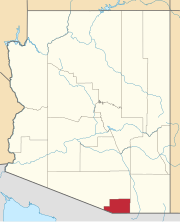
 Madera Canyon Location within the state of Arizona  Madera Canyon Madera Canyon (the United States) | |
| Coordinates: 31°43′30″N 110°52′48″W | |
| Country | United States |
| State | Arizona |
| County | Santa Cruz |
| Elevation | 4,911 ft (1,497 m) |
| Time zone | UTC-7 (Mountain (MST)) |
| • Summer (DST) | UTC-7 (MST) |
| Area code(s) | 520 |
| FIPS code | 04-43710 |
| GNIS feature ID | 36713 |
References
- "Feature Detail Report for: Madera Canyon". Geographic Names Information System. United States Geological Survey.
- "Madera Canyon (in Santa Cruz County, AZ) Populated Place Profile". AZ Hometown Locator. Retrieved December 21, 2016.
- United States Geological Survey (1996). Mount Hopkins, AZ (PDF) (Topographic map). 1:24,000. 7.5 Minute Series. United States Geological Survey. Retrieved 9 September 2021.
Текст в блоке "Читать" взят с сайта "Википедия" и доступен по лицензии Creative Commons Attribution-ShareAlike; в отдельных случаях могут действовать дополнительные условия.
Другой контент может иметь иную лицензию. Перед использованием материалов сайта WikiSort.org внимательно изучите правила лицензирования конкретных элементов наполнения сайта.
Другой контент может иметь иную лицензию. Перед использованием материалов сайта WikiSort.org внимательно изучите правила лицензирования конкретных элементов наполнения сайта.
2019-2025
WikiSort.org - проект по пересортировке и дополнению контента Википедии
WikiSort.org - проект по пересортировке и дополнению контента Википедии
